

- Geomorphology
- Climate Factors: Natural, Human Influences on Earth's Climate
- Oceans & Marine Life: Resources, Geography, Currents, & More
- Distribution of Minerals in India: Key Mineral Belts & Sustainable Mining
- Disaster and Hazard: Definition, Impact & Risk Reduction in India
- Continental Drift Theory: Explanation, Evidence & Geological Impact
- Seafloor Spreading: Process, Evidence, Rate, Significance in Plate Tectonics
- Mapping of the Ocean Floor: Bathymetry, Techniques, and Global Landforms
- The Hydrosphere & Cryosphere: Earth's Water & Climate Systems
- Earth's Heat Budget: Energy Balance, Greenhouse Effect, and Climate Change
- Pressure Belts of the Earth: Types, Features & Importance in Climate
- Understanding Air Masses and Their Impact on Macro Climatic Changes
- Monsoon Climate: Characteristics, Importance, Role of Atmospheric Layers
- Impact of Climate on Desertification
- Temperature Inversion: Causes, Impacts & Meteorological Significance
- Heat Islands
- Heat Dome
- Coral Reefs
- Tides: Types, Gravitational Forces, Importance, and Renewable Energy
- Marine Coastal Ecosystems: Types, Importance, Threats & Conservation
- Marine Pollution: Causes, Impacts, Dead Zones & Global Solutions
- Power and Energy Sector in India: Growth, Challenges & Opportunities
- India's Power Sector in 2030: Transforming the Energy Landscape
- Solar Energy in India: Revolutionizing the Power Sector
- National Green Hydrogen Mission: Objectives, Significance, Challenges & Future of Clean Energy in India
- India’s Natural Gas Policy, CGD Projects, Infrastructure Development, Petroleum Ministry
- Lithium Reserves
- Rare Earth Metals
- India Strategic Oil Reserve
- Atomic Minerals in India: Uranium and Thorium Reserves & Distribution
- USA-led Minerals Security Partnership (MSP)
- Role and Importance of Industrial Corridors in India’s Economic Development
- Global and Indian Industrial Regions: Factors, Major Hubs & IT Sector Growth
- Mangroves in India: Importance, Threats & Conservation Initiatives
- Desertification: Causes, Impacts, Status in India & Global Solutions
- Soil Erosion: Causes, Effects & Prevention Methods Explained
- Environmental Implications of the Reclamation of the water bodies
- Forest Resources in India: Importance, Current Status & Conservation
- Social Forestry in India: Types, Benefits, and Government Initiatives
- Earthquakes in India: Causes, Effects, Zones, and Mitigation Strategies
- Cyclones: Types, Causes, Formation, Impacts & Safety Measures Explained
- El Niño, La Niña, and ENSO
- Tsunami: Causes, Effects, Warning Systems, NDMA Guidelines in India
- Landslides
- Landslide Atlas of India
- Floods
- Cloudbursts in India: Causes, Impact & Climate Change Link
- Urban Floods in Indian Cities: A Growing Crisis
- Forest Fire
- Urban Fire, Lightning & Railway Disasters in India: Causes, Challenges & Solutions
- Chemical disasters
- Disaster Management Plan for Power Sector
- Vulnerability in Disasters: Causes, Factors & Mitigation
- Disaster resilience
- Sendai Framework for Disaster Risk Reduction
- India's efforts in disaster management
- Crowd Management and Disasters Due to Large Crowd Presence
1. Geomorphology
Geomorphology
Big Bang Theory or Expanding Universe Hypothesis
- The universe began with a tiny, dense ball called the "Tiny Ball" or Big Bang.
- The Big Bang occurred about 13.7 billion years ago and caused a violent explosion.
- The universe rapidly expanded at first, but the expansion has since slowed down.
- While space between galaxies is increasing, observations do not support the idea that galaxies themselves are expanding.
Formation of Stars and its Life Cycle
- Stars formed billions of years ago from growing nebulae, which are dense clouds of gas and dust in space.
- Galaxies are vast collections of stars spread across immense distances measured in light-years.
- Constellations are patterns formed by groups of stars, such as Ursa Major or the Big Bear.
- Stars were used by ancient people for navigation and determining directions at night.
- The North Star, also known as the Pole Star, remains fixed in the sky and indicates the north direction.
Solar/Stellar Flare
- Solar flares are sudden brightness surges on stars due to magnetic energy release.
- They occur near sunspots, often paired with coronal mass ejections.
- These flares eject clouds of electrons, ions, atoms, and radiation.
- Strong flares, like those from Proxima Centauri, can strip water and sterilize grounds.
- If a solar flare is directed at Earth, it can cause auroras.
- These flares' X-rays and UV rays can disrupt long-range radio communication.
- They pose significant radiation risks for manned space missions.
Sunspot Cycle
- The amount of magnetic flux that rises up to the Sun's surface varies with time in a cycle called the solar cycle or sunspot cycle, which lasts approximately 11 years on average, is sometimes referred to as the sunspot cycle.
- Sunspots are darker, magnetically strong, and cooler areas on the surface of the Sun. Sunspots are not present all over the Sun but are found between 25°-30° latitude.
|
Understanding the long-term variations of the Sun and its impact on Earth's climate is one of the objectives of the Aditya L-1 Mission. |
Dwarf Planet
- A celestial body that orbits around the Sun. It has sufficient mass for its self-gravity to overcome rigid body forces, resulting in a nearly round shape (hydrostatic equilibrium).
- It has not cleared the neighborhood around its orbit. It is not a satellite.
- Prominent Dwarf Planets: Pluto, Ceres, Makemake, Haumea, Eris
Interior of the Earth
Sources of information about the Earth's interior
|
Direct Sources |
Indirect Sources |
|
|
Seismic Waves
The study of seismic waves provides a complete picture of earth’s layered interior.Causes of Earthquakes
Sudden Energy Release along Fault: The abrupt release of energy along a fault generates seismic waves.Faults in the Earth's Crust: Faults are sharp fractures in the Earth's crustal rock layer.
Opposing Movement of Rocks: Rocks adjacent to a fault tend to move in opposite directions. Friction from overlying rock strata prevents the movement of rocks.
Accumulation of Pressure: Over time, pressure builds up in the rocks due to the hindered movement.
Overcoming Friction and Sudden Movement: Under intense pressure, the rock layer overcomes friction and experiences a sudden movement, leading to the generation of shockwaves.
Focus and Epicenter: The point where energy is released is called the focus or hypocenter. The waves reach the surface. The epicenter is the point on the surface nearest to the focus, directly above it.
Earthquake Waves
Natural Occurrence in the Lithosphere: Natural earthquakes happen within the lithosphere, which encompasses the upper 200 kilometers of the Earth's surface.Seismographs for Wave Recording: Seismographs are instruments used to record waves reaching the surface during an earthquake.
Classification of Waves: Earthquake waves can be categorized into two types: body waves and surface waves.
Origin and Propagation of Body Waves: Body waves originate from the energy release at the earthquake's focus and propagate in all directions through the Earth's interior.
Interaction and Generation of Surface Waves: Body waves interact with surface rocks, generating surface waves that move along the Earth's surface.
Velocity Variation and Material Elasticity: The velocity of seismic waves changes as they travel through materials with different elasticity or stiffness, and sometimes density.
Directional Changes: Waves can reflect or refract when encountering materials with varying densities, resulting in changes in their direction.
Primary Waves (P-waves) and Secondary Waves (S-waves): P-waves are longitudinal waves that propagate faster and arrive first at the surface, while S-waves are transverse waves that follow with a time lag.
Propagation of Earthquake Waves
Earthquake waves of different types travel in distinct ways, causing vibrations in rocks as they propagate.P-waves vibrate parallel to the wave's direction, exerting pressure on the material and creating density differences that result in stretching and squeezing.
The other two waves vibrate perpendicular to the propagation direction, with S-waves vibrating perpendicular in the vertical plane, forming troughs and crests in the material they pass through.
Emergence of Shadow Zone
Each earthquake has its own unique shadow zone, as shown in Figure alongside depicting the shadow zones of P and S-waves.
Seismographs within 105° from the epicenter record the arrival of both P and S-waves, while those beyond 145° only detect P-waves.
Thus, the zone between 105° and 145° from the epicenter is identified as the shadow zone for both wave types, with S-waves not reaching beyond 105°.
The shadow zone for S-waves is larger, covering over 40% of the Earth's surface, while the shadow zone for P-waves appears as a band between 105° and 145° away from the epicenter.
Determining the Earth's Interior through the Characteristics of 'P' and 'S' Waves
Reflection causes waves to rebound, while refraction changes their direction. By observing the record of waves on seismographs, the variations in wave direction can be inferred.Changes in density significantly affect wave velocity, allowing estimation of the Earth's overall density by observing velocity changes.
The emergence of shadow zones (changes in wave direction) helps identify different layers within the Earth.
Earth's Layers
Earth's layers are identified by studying various direct and indirect sources. The structure of the earth's interior consists of several concentric layers.Three main layers can be identified: crust, mantle, and core.
Seismic Discontinuities
Earth's Layers Based on Chemical Properties
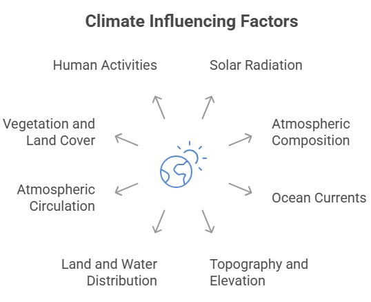
2. Climate Factors: Natural, Human Influences on Earth's Climate
Climate refers to the long-term average weather conditions of a particular region or the Earth as a whole. It is influenced by various factors that can be categorized into natural factors and human factors. Understanding these factors is essential for comprehending climate patterns and predicting future changes.
- Solar Radiation: Solar radiation from the Sun is the primary source of energy for the Earth's climate system. The amount of solar radiation received by different parts of the Earth varies due to factors such as the Earth's tilt, distance from the Sun, and variations in solar activity. These variations play a significant role in shaping global and regional climate patterns.
- Atmospheric Composition: The composition of gases in the Earth's atmosphere affects the climate. The greenhouse gases, such as carbon dioxide (CO2), methane (CH4), nitrous oxide (N2O), and water vapor, trap heat in the atmosphere and contribute to the greenhouse effect. Changes in the concentration of these gases, particularly due to human activities like burning fossil fuels and deforestation, can lead to an increase in global temperatures (global warming) and alter climate patterns.
- Ocean Currents: Ocean currents influence climate by redistributing heat around the globe. Warm ocean currents carry heat from the equator toward the poles, affecting the temperature and precipitation patterns in coastal regions. Cold ocean currents bring cooler water from polar regions to lower latitudes, influencing the climate of adjacent land areas.
- Topography and Elevation: The physical features of the Earth's surface, such as mountains, valleys, and plateaus, can significantly impact climate. Mountain ranges act as barriers to airflow, causing air to rise and cool, resulting in increased precipitation on windward slopes and a rain shadow effect on the leeward side. Higher elevations generally experience cooler temperatures due to decreased atmospheric pressure and reduced air density.
- Land and Water Distribution: The distribution of land and water on the Earth's surface affects climate. Land heats up and cools down faster than water, leading to temperature contrasts between coastal and inland areas. Large water bodies, such as oceans and lakes, can moderate temperatures by absorbing and releasing heat, influencing the adjacent land areas.
- Atmospheric Circulation: The movement of air in the atmosphere plays a crucial role in climate patterns. Solar radiation drives atmospheric circulation, leading to the formation of global wind belts and weather systems. The interplay between high-pressure systems (anticyclones) and low-pressure systems (cyclones) determines wind patterns, precipitation, and the distribution of weather systems across the Earth.
- Vegetation and Land Cover: Vegetation and land cover have a significant impact on climate. Forests, grasslands, and other types of vegetation influence local and regional climates by affecting evapotranspiration, which influences humidity and precipitation patterns. Deforestation and land use changes can disrupt these patterns, leading to alterations in local and regional climate conditions.
- Human Activities: Human activities have increasingly become a significant factor affecting climate. Activities such as burning fossil fuels, deforestation, industrial processes, and agriculture contribute to the release of greenhouse gases, leading to global warming and climate change. Land-use changes, urbanization, and pollution also affect local climate conditions.
Conclusion
It's important to note that these factors interact with each other in complex ways, and changes in one factor can have cascading effects on others. Scientists study these factors and their interactions through various methods, including climate models, to understand and predict climate changes, enabling us to make informed decisions and develop strategies to mitigate and adapt to the impacts of climate change.
3. Oceans & Marine Life: Resources, Geography, Currents, & More
Oceans & Marine Life: The oceans, encompassing around 70% of Earth's surface, stand as the largest and most prominent feature on our planet, defining its unique character. With a single interconnected body of water known as the world ocean, it is divided into five principal oceans viz. the Pacific, Atlantic, Indian, Southern, and Arctic Oceans.
Marine Resources: Supporting Oceans & Marine Life
Marine resources consist of the oceans and seas, covering about 70% of the Earth's surface. These vast bodies of saltwater harbor an immense wealth of resources.
- Marine Organisms: Oceans are home to a diverse array of organisms, many of which are harvested for human consumption. This includes fish, shellfish, and seaweed.
- Mineral Resources: Oceans contain vast amounts of mineral resources. These include oil and natural gas reserves, sand and gravel, and various polymetallic nodules containing manganese, copper, cobalt, and nickel.
- Energy Resources: Marine resources also include renewable energy sources like wind, wave, tidal, and thermal energy.
Divisions of the Ocean Floor: Shaping Oceans & Marine Life Habitats
The ocean floor can be classified into several major divisions that play important roles in the Earth's geography - Continental-Oceanic margin, Continental Shelf, Continental Slope, Continental Rise, Deep ocean plains, and Oceanic Ridges.
Continental-Oceanic Margin
The continental-oceanic margin is a significant division of the ocean floor, characterized by its unique features and geological processes.

Continental Shelf
The continental shelf, an extension of the continent, exhibits various characteristics that vary across different regions. Its width, angle, and depth play crucial roles in shaping coastal areas.
- Angle: The continental shelf has a slight inclination, typically around 10.
- Depth: The depth of the continental shelf ranges from shallow areas of about 30 meters to deeper regions of up to 600 meters.
- Width: The width of the continental shelf varies greatly, with examples such as the wide shelves in the Bay of Bengal and the East Coast of North America, contrasting with the virtually absent shelf on the West Coast of South America.
- Sedimentary Deposits: The continental shelf is covered with sediments, including those brought down by rivers and glaciers.
- Shelf Break: The continental shelf ends with a steep slope known as the shelf break.
Continental Slope
The continental slope connects the continental shelf to the ocean basins and exhibits distinct features and characteristics.
- Steep Slope: The continental slope steepens abruptly at the edge of the continental shelf.
- Gradient: The slope region's gradient ranges from 2° to 5°.
- Depth: The depth of the slope region varies between 200 meters and 3 kilometers.
- Continental Rise: The seaward edge of the continental slope gradually loses gradient, giving rise to the continental rise.
- Canyons and Trenches: Canyons and trenches are prominent features observed in the continental slope region.
Continental Rise
- The continental rise is a sediment underwater feature located between the continental slope and the abyssal plain.
- It forms through the gradual deposition of sediments transported by rivers and other sources.
Deep Ocean Plains (Abyssal Plain)
The deep ocean plains, also known as abyssal plains, cover a significant portion of the ocean floor and possess distinctive characteristics.
- Gentle Slope: At the end of the continental slope, the slope becomes gentler, ranging from 50 to 10.
- Extent: Abyssal plains lie 2-3 miles below sea level and cover approximately 40% of the ocean floor.
- Sediment Cover: These plains are covered with fine-grained sediments like clay and silt.
- Distribution: Abyssal plains are found between the foot of a continental rise and a mid-ocean ridge, constituting over 50% of the Earth's surface.
Oceanic Ridges
Oceanic ridges are continuous underwater mountain ranges formed by tectonic activity and volcanic processes.
- Formation: Oceanic ridges are created when magma rises between diverging plates of the lithosphere, resulting in the formation of a new layer of crust.
- Structure: They consist of two chains of mountains separated by a large depression, which marks a divergent boundary.
Minor Relief Features of Oceans & Marine Life Environments
In addition to the major divisions, the ocean floors host various minor relief features that contribute to the overall complexity and diversity of underwater landscapes.
|
Relief Features |
Description |
|
Submarine Canyons |
Deep concave gorges on the continental shelf, slope, or rise, often extending from the mouths of large rivers. |
|
Trenches |
|
|
Sea mounts |
|
|
Abyssal hills |
|
|
Guyots |
|
Marginal Seas: Key to Oceans & Marine Life Diversity
- Marginal seas are divisions of oceans, partially enclosed by land formations such as islands, archipelagos, or peninsulas. They are either open to the open ocean or bounded by submarine ridges on the sea floor.
- Examples of Marginal Seas: Arabian Sea, Persian Gulf, Red Sea, Gulf of Oman, Gulf of Aden, Gulf of Kutch, Gulf of Khambat, Bay of Bengal, Andaman Sea, Malacca Strait, Mozambique Channel, Great Australian Bight, Gulf of Mannar, Laccadive Sea.
Ocean Temperature
- The study of ocean temperature is important for understanding ocean currents, marine organism distribution, and coastal climate.
- Insolation (incoming solar radiation) is the primary energy source for ocean temperature.
- Oceans play a crucial role in energy and temperature regulation due to their high heat capacity.
- The average temperature of the oceans is around 3-5 degrees Celsius, while the average surface temperature of ocean water is about 25 degrees Celsius.
Factors Affecting Temperature Distribution
|
Latitude |
|
|
Hemispheric Variation |
|
|
Prevailing Winds |
|
|
Ocean Currents |
|
|
Enclosed and Open Sea |
|
|
Physical Characteristics of the Sea Surface |
|
|
Diurnal Range of Temperature |
|
|
Annual Range of Temperature |
|
Variation in Ocean Temperature
- The equator receives about four times more average incoming solar energy than the poles. Solar radiation can penetrate below the ocean's surface due to water's transparency.
- Shorter wavelengths (high energy) penetrate deeper than longer wavelengths, transferring heat to deeper levels through mixing.
- Diurnal and seasonal temperature variations in water are relatively small compared to land due to water's high specific heat.
- Most solar energy is absorbed near the ocean surface, providing energy for photosynthesis by marine plants and algae.
Vertical Variation in Oceanic Temperature
- The vertical distribution of temperature in the deep ocean is influenced by density-driven water movements.
- The maximum temperature of oceans is found at the surface due to direct solar energy.
- Heat conduction alone transfers only a small proportion of heat downward; convection plays a crucial role in transmitting heat to lower sections of the oceans.
Thermal Layer Distribution in the Ocean
- 1st layer: The top layer consists of warm oceanic water with a thickness of about 500 meters and a temperature range of 20-25°C.
- This layer exists throughout the year in tropical regions but develops only during summer in mid-latitudes.
- 2nd layer: Temperature rapidly declines between depths of about 200 meters to 1000 meters, forming the permanent thermocline.
- About 90% of the total volume of water lies below the thermocline, with temperatures approaching 0°C.
- The thermocline is less pronounced in Polar Regions due to surface temperatures close to 0°C.
- 3rd layer: Beyond 1000 meters, there is virtually no seasonal variation, and temperatures remain around 2°C.
- This layer extends to the deep ocean floor and is influenced by the temperature of cold, dense water sinking at the polar regions and flowing toward the equator.
Horizontal Variation in Oceanic Temperature

- The average temperature of surface water in the ocean is around 27°C. Average temperature gradually decreases from the equator towards the poles.
- The southern hemisphere generally records lower temperatures than the northern hemisphere due to unequal land and water distribution.
- The highest temperature is usually slightly away from the equator in the northern direction.
Salinity: Another Key to Oceans & Marine Life Dynamics
- Salinity refers to the amount of salt (in grams) dissolved in 1,000 grams (1 kg) of seawater. It is commonly expressed as parts per thousand (ppt) or o/oo.
- A salinity of 7 ppt is considered the upper limit for "brackish water."
- Even slight variations in ocean surface salinity can have significant impacts on the water cycle and ocean circulation.
Factors Affecting Salinity
|
Factors that increase salinity |
Factors that decrease salinity |
|
|
Sources of Salts in Ocean Water
- Sediments carried by rivers contribute to the salt content.
- Submarine volcanism at Oceanic Ridges releases minerals into the water.
- Chemical reactions between rocks from geothermal vents or volcanoes and cold water.
- Erosion of oceanic rocks.
Distribution of Salinity
- Vertical Distribution: Salinity changes with depth, leading to stratification. The halocline is a distinct zone where salinity increases sharply.
- Horizontal Distribution: Salinity is highest near the tropics and decreases towards the equator and poles. Heavier rainfall near the equator incorporates freshwater, while less evaporation near the poles prevents water molecule removal.
Relationship Between Salinity, Temperature, and Density
- Temperature and density have an inverse relationship. As temperature increases, the space between water molecules increases, reducing salinity. Water reaches its maximum density at 4°C.
- Density and salinity have a positive relationship. As density increases, so does salinity.
- Differences in density between warm and cold seawater drive ocean currents and upwelling. Warm seawater floats, while cold and dense seawater sinks.
Variation of Density, Salinity, and Temperature with Oceanic Depth
- Rapid changes in temperature, density, or salinity create distinct regions known as clines.
- Thermoclines represent areas of rapid temperature change, pycnoclines indicate rapid density change, and haloclines reflect rapid salinity change.
Ocean Currents: Driving Forces for Oceans & Marine Life
Introduction
- Ocean movements are classified into waves, tides, and currents.
- Waves form due to friction between wind and the ocean's surface. They diminish near the shore or shallow waters.
- Horizontal currents result from wind-water friction, Earth's rotation, Coriolis force, and differences in water level gradient.
- Vertical currents are driven by density variations caused by temperature and salinity changes.
- Ocean currents are crucial movements that significantly impact regional climatology. Similar to river flows, they represent a regular volume of water flowing in a specific path and direction.
- Ocean currents are influenced by two types of forces: primary forces that initiate the movement and secondary forces that influence the flow.
Primary Forces Responsible for Ocean Currents
- Influence of Insolation: Solar heating causes water to expand, creating a slight gradient that leads to the flow of water from east to west.
- Influence of Wind (Atmospheric Circulation): Wind pushes the ocean's surface water and affects its movement through friction. Magnitude and direction of ocean currents are influenced by wind, with monsoon winds playing a role in seasonal reversal of currents in the Indian Ocean.
- Influence of Gravity: Gravity causes water to pile up and creates variations in gradient.
- Influence of Coriolis Force: Coriolis force deflects water movement to the right in the northern hemisphere and to the left in the southern hemisphere. Gyres, large accumulations of water, form circular currents in all ocean basins. An example is the Sargasso Sea.
Secondary Forces Responsible for Ocean Currents
- Secondary forces include temperature and salinity differences. Differences in water density impact vertical ocean currents.
- Water with higher salinity and colder temperature is denser and tends to sink, while lighter and warmer water rises. Cold-water currents form as cold water from the poles sinks and slowly moves towards the equator.
- Warm-water currents flow from the equator along the surface, replacing the sinking cold water and moving towards the poles.
Types of Ocean Currents
Based on Depth
- Ocean currents can be classified into two types based on their depth: surface currents and deep water currents.
- Surface currents: These currents make up about 10% of the ocean's water and occupy the upper 400 meters of the ocean.
- Deep water currents: Accounting for the remaining 90% of ocean water, deep water currents circulate within the ocean basins due to density and gravity variations.
- At high latitudes, deep waters sink into the ocean basins where cold temperatures increase their density.
Based on Temperature
- Cold currents: These currents bring cold water from high latitudes to low latitudes. They are typically found on the west coast of continents in low and middle latitudes in both the Northern and Southern Hemispheres. In the Northern Hemisphere, they are present on the east coast in higher latitudes.
- Warm currents: Warm currents transport warm water from low to high latitudes. They are commonly observed on the east coast of continents in low and middle latitudes in both hemispheres. In the Northern Hemisphere, they flow along the west coasts of continents in high latitudes.
General Characteristics of Ocean Currents
- The movement of ocean currents follows a general pattern of clockwise circulation in the northern hemisphere and counterclockwise circulation in the southern hemisphere. This is due to the deflective force of the Coriolis force, following Ferrel's law.
- An exception to this pattern is seen in the northern Indian Ocean, where the current direction changes with the seasonal shift in monsoon winds. Warm currents tend to move towards cold seas and vice-versa.
- In lower latitudes, warm currents flow along the eastern shores and cold currents along the western shores. This situation is reversed in higher latitudes.
- Convergence occurs when warm and cold currents meet, while divergence happens when a single current splits into multiple currents flowing in different directions.
- The shape and position of coastlines play a significant role in guiding the direction of currents.
- Currents exist not only on the ocean's surface but also below it, influenced by differences in salinity and temperature. For example, the heavy surface water of the Mediterranean Sea sinks and forms a sub-surface current that flows westward past Gibraltar.
Effects of Ocean Currents
|
Effects of the Ocean Currents |
Description |
|
Desert Formation |
|
|
Rains |
|
|
Moderating Effect |
|
|
Fishing |
|
|
Drizzle |
|
|
Climate |
|
|
Tropical Cyclones |
|
|
Navigation |
|
Bays, Gulfs, Straits, and Isthmus: Features Impacting Oceans & Marine Life
|
Types |
Description |
|
Bays |
|
|
Gulfs |
|
|
Straits |
|
|
Isthmus |
|
Continental Shelf Deposits: Resources for Oceans & Marine Life
|
Properties of Continental Shelf Deposits |
|
|
Resources Found in Continental Shelves |
|
|
Resources from Abyssal Plains |
|
Poly Metallic Nodules (PMNs)
- Characteristics of PMNs: PMNs are potato-sized lumps of minerals found in the deep sea, ranging in size from millimeters to tens of centimeters in diameter.
- Composition: PMNs contain valuable metals such as nickel, copper, cobalt, lead, cadmium, vanadium, molybdenum, and titanium, with nickel, cobalt, and copper being economically significant.
- Abundance: PMNs are abundant and widely distributed across the sea floor of all oceans.
- India's Pioneering Efforts: India became the first country to receive the status of a pioneer investor for exploring and utilizing PMNs. It was allocated an exclusive area in the Central Indian Ocean Basin by the United Nations in 1987.
- Samudrayaan Project: India's National Institute of Ocean Technology (NIOT) is set to launch the "Samudrayaan project" by 2021-22 as part of the "Deep Ocean Mission."
- The project aims to explore the deep sea region using an indigenously developed submersible vehicle with a capacity to carry three persons to a depth of about 6000 meters for underwater studies.
Significance of Polymetallic Nodules
- Rare Earth Elements: PMNs contain rare earth elements and metals that are crucial for high-tech industries.
- Abundance of Copper: The CCZ nodules are estimated to hold approximately 20% of the copper reserves found in global land-based sources.
- Valuable Minerals: Rare earth minerals present in PMNs, such as gold, silver, and zinc, hold significant value.
- Reducing Dependence on China: With China currently controlling over 95% of rare earth metals, India's exploration efforts aim to reduce dependence on China's dominance in this sector.
Challenges of Polymetallic Nodule Mining
- Economic Viability: Extracting metals from PMNs is currently not economically viable.
- Environmental Concerns: Deep sea mining must be approached with caution to prevent disturbances in the delicate aquatic ecosystem.
UN Convention on the Law of the Sea (UNCLOS): Governing Oceans & Marine Life
- The UN Convention on the Law of the Sea governs issues related to deep sea mining, environmental protection, maritime boundaries, and dispute settlement.
|
Ocean Classification |
UNCLOS Sections |
|
Territorial Waters |
|
|
Contiguous Zone |
|
|
Exclusive Economic Zones (EEZs) |
|
International Seabed Authority
- An intergovernmental body established in 1994 under the Law of the Sea Convention. It regulates and controls all mineral-related activities in the international seabed area beyond national jurisdiction.
- Its primary goal is to protect the marine ecosystem while organizing and overseeing mineral exploration and exploitation.
- The International Seabed Authority operates under the United Nations Convention on the Law of the Sea (UNCLOS).
- It has its headquarters in Jamaica and holds an observer status to the UN. The total area under its regulation accounts for more than 54% of the world's oceanic surface.
- India is a member of the International Seabed Authority and has committed to sustainable development through Agenda 2030.
Deserts and Trade Winds
- The aridity of hot deserts is primarily influenced by the effects of offshore Trade Winds, earning them the name Trade Wind Deserts.
- Major hot deserts, such as the Sahara Desert (3.5 million square miles), the Great Australian Desert, Arabian Desert, Iranian Desert, Thar Desert, Kalahari Desert, and Namib Desert, are located on the western coasts of continents between latitudes 15° and 30°N and S.
- These deserts lie along the Horse Latitudes or Sub-Tropical High Pressure Belts, where descending air suppresses precipitation.
- Rain-bearing Trade Winds blow offshore, while the onshore Westerlies blow outside the desert limits.
- Winds reaching the deserts blow from cooler to warmer regions, resulting in lowered relative humidity and minimal condensation.
- The absence of clouds and extremely low relative humidity, ranging from 60% in coastal districts to less than 30% in desert interiors, lead to permanent drought conditions. Precipitation is scarce and highly unpredictable.

Indian Ocean Currents and Monsoons: Seasonal Shifts for Oceans & Marine Life
- The currents in the northern portion of the Indian Ocean exhibit seasonal changes in response to the rhythm of the monsoons. The influence of winds on the Indian Ocean currents is particularly significant.
Winter Circulation
- Under the influence of prevailing easterly trade winds, the north equatorial current and the south equatorial current originate south of the Indonesian islands, moving from east to west.
- This elevation of the western Indian Ocean (southeast of the horn of Africa) raises the water level by a few centimeters, resulting in the formation of a counter equatorial current that flows in a west-east direction between the north equatorial current and the south equatorial current.
- During the northeast monsoons, the water along the coast of the Bay of Bengal circulates in an anticlockwise direction. Similarly, there is an anticlockwise circulation of water along the coast of the Arabian Sea.
Summer Circulation - North Equatorial Current Counter-Equatorial Current are absent
- In summer, due to the strong southwest monsoon and the absence of the northeast trade winds, a strong current flow from west to east, completely overriding the north equatorial current.
- Consequently, there is no counter-equatorial current As a result, the circulation of water in the northern part of the ocean during this season is clockwise.
Southern Indian Ocean Currents - Agulhas Current, Mozambique Current, West Australian Current
- The circulation pattern in the southern part of the Indian Ocean resembles that of the southern Atlantic and Pacific Oceans and is less affected by seasonal changes.
- The south equatorial current, partly influenced by its Pacific Ocean counterpart, flows from east to west.
- It splits into two branches: one flowing to the east of Madagascar known as the Agulhas current, and the other between Mozambique and the western coast of Madagascar known as the Mozambique current.
- These two branches merge at the southern tip of Madagascar, forming the Agulhas current, which remains a warm current until it joins the West Wind Drift.
- The West Wind Drift, flowing from west to east across the higher latitudes of the ocean, reaches the southern tip of the west coast of Australia.
- One branch of this cold current turns northwards along the west coast of Australia, known as the West Australian current, and flows northward to contribute to the south equatorial current.
4. Distribution of Minerals in India: Key Mineral Belts & Sustainable Mining
Minerals are naturally occurring substances with unique chemical compositions and crystalline structures found in the Earth's crust.
Distribution of Minerals in India
1. Uneven Distribution- Minerals are distributed unevenly on the earth's surface.
- All minerals are exhaustible in nature and will deplete over time.
- While minerals take a long time to form, they cannot be replenished immediately when needed.
- Over 97% of coal reserves are found in the valleys of Damodar, Sone, Mahanadi, and Godavari rivers.
- India's domestic coal reserves have a high ash content of 40-45%.
- Most coal-based power plants lack flue-gas desulphurization technology, contributing to air pollution. Coal burning releases particulate matter, sulphur dioxide, nitrogen oxide, and mercury.
- Petroleum reserves are located in the sedimentary basins of Assam, Gujarat, and Mumbai High (off-shore region in the Arabian Sea).
- New petroleum reserves are also found in the Krishna-Godavari and Kaveri basins.

Mineral Belts in India
|
Region |
Description |
|
North-Eastern Plateau Region |
|
|
South-Western Plateau Region |
|
|
North-Western Region
|
|
Distribution of Key Mineral Resources in India
Scope of the Mining Sector in India
- Mining Operations: Mineral belts are hotspots for the extraction of resources like coal, iron ore, and limestone.
- Industrial Development: These mineral deposits drive industrial growth, especially in sectors like steel and power generation.
- Employment: Mining in these areas creates jobs, boosting local economies.
- Revenue: Mineral extraction provides government revenue through royalties and taxes, supporting public infrastructure and welfare.
- Infrastructure: Efficient transportation and regional growth necessitate infrastructure development in mineral belts.
- Research: Mineral belts offer research opportunities for the discovery and assessment of deposits, expanding the mining sector.
- Sustainability: These belts can uphold sustainable mining practices, promoting environmental protection and social responsibility.
Challenges of the Mining Sector in India
- Environmental Concerns: Balancing mineral extraction with sustainable environmental practices is a challenge due to potential impacts such as deforestation, soil erosion, water pollution, and habitat destruction.
- Regulatory Framework: Complex regulations and legal requirements pose challenges for mining companies due to the intricate regulatory framework governing the mining sector in India.
- Land Acquisition and Community Displacement: Acquiring land and managing community displacement present challenges for mining companies, necessitating careful planning, consent, and rehabilitation measures.
- Infrastructure Development: It creates logistical and operational challenges for developing transportation networks and power supply crucial for efficient mineral extraction and processing.
- Technological Advancements: The availability and adoption of modern technologies pose challenges for smaller mining companies and remote areas in maximizing mineral extraction, minimizing environmental impacts, and adopting advanced mining technologies and equipment.
Distribution of Minerals in India: Sand Mining Framework
|
Distribution of Minerals in India: Critical Minerals Report
|
Way Forward
- Sustainable Mining Practices: Promote responsible techniques, advanced technologies, and community engagement.
- Strengthen Regulatory Framework: Streamline regulations, reduce bureaucracy, and ensure effective monitoring.
- Community Engagement and Consent: Involve local communities in decision-making and obtain their consent.
- Infrastructure Development: Prioritize infrastructure investment for transportation, power, and water management.
- Research and Development: Encourage collaboration and innovation for sustainable mining practices.
- Capacity Building and Skill Development: Invest in training to enhance skills and promote responsible mining.
- Stakeholder Collaboration: Foster dialogue among government, companies, communities, and environmental organizations.
5. Disaster and Hazard: Definition, Impact & Risk Reduction in India
A disaster is a catastrophic event—natural or man-made—that causes widespread loss of life, property, and economic stability. While all disasters stem from hazards, only when these hazards cause actual harm do they become disasters.
What is a Disaster?
- A disaster is a mishap or hazard which causes huge loss of life and property and disrupts the balance of the economy. It is a tragic event with drastic consequences for living beings as well as social and individual development.
- A disaster can be caused by either natural or man-made factors. Both these factors need to be taken care of to prevent a disaster or lessen its impact.
- Disasters also arise due to inefficient management of risks. If a safety net is devised to address the potential risks, it would lead to reduction in damages triggered by disasters. Developing countries are more vulnerable to disasters.
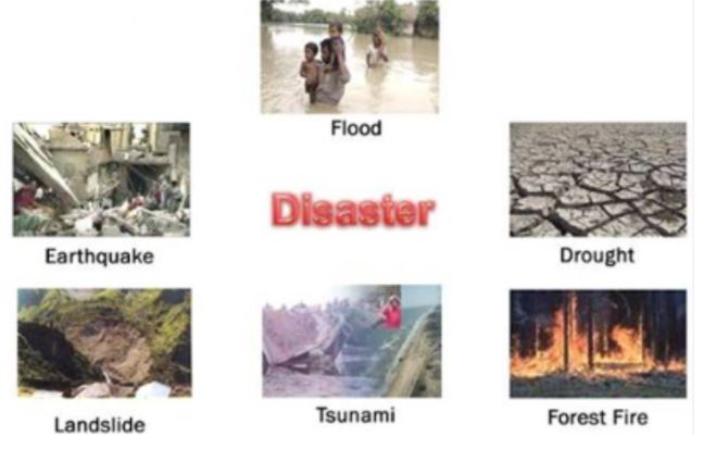
What is a Hazard?
- A hazard is any phenomena that has the potential to cause destruction to life and property. A hazard become a disaster when the potential to cause destruction is fulfilled. When there is harm to life and property of humans, the hazard is termed a disaster.
- Hazards do not necessarily cause any destruction. If an earthquake was to hit a barren mountain with no human community, it would simply be a natural phenomenon; or a natural hazard. Hazards can be geological (the most common), biological (epidemics) or chemical (nuclear power plant leaks, chemical industry leaks, etc).
- Thus, all disasters are hazards, but all hazards are not disasters.
Classification of Disasters

Impact of Disaster
Disaster Risk Reduction in India Status Report 2020: Impact of Disasters
|
6. Continental Drift Theory: Explanation, Evidence & Geological Impact
Continental Drift Theory, also known as the theory of plate tectonics, is a scientific concept that explains the movement of Earth's continents over time. It was first proposed by Alfred Wegener in the early 20th century and has since become a fundamental theory in the field of geology.
Introduction to Continental Drift Theory
Continental Drift Theory suggests that the Earth's continents were once joined together in a single supercontinent called Pangaea. According to this theory, the continents have since drifted apart, moving slowly over millions of years to their current positions.
Evidence Supporting the Continental Drift Theory

- Fit of the continents: The coastlines of South America and Africa fit remarkably well when placed together. Similar fits were found between other continents.
- Fossil evidence: Similar fossils of plants and animals were found on different continents that are currently separated by vast oceans. This indicates that the continents were once connected.
- Rock formations and mountain ranges: Geological formations and mountain ranges, such as the Appalachian Mountains in the eastern United States and the Caledonian Mountains in the British Isles, line up across continents, suggesting a shared history.
- Paleoclimatic evidence: ancient climate indicators, such as glacial deposits and coal deposits, were found in regions that currently have different climates. This indicates that these regions were once in different latitudes.
- Ancient magnetic field: Magnetic minerals in rocks record the Earth's magnetic field at the time of their formation. Magnetic anomalies on both sides of the mid-ocean ridges provide evidence for seafloor spreading.
Rejection and Acceptance of the Continental Drift Theory
- Wegener's theory faced significant skepticism and rejection during his time, primarily because he couldn't explain the mechanism behind the movement of continents.
- It was not until the 1960s that advancements in technology and new evidence, such as mapping the ocean floor, provided a mechanism for continental drift through the theory of plate tectonics.
- The theory of plate tectonics explains that the Earth's lithosphere is divided into several large and small plates that float on the semi-fluid asthenosphere. The movement of these plates explains the drifting of continents.

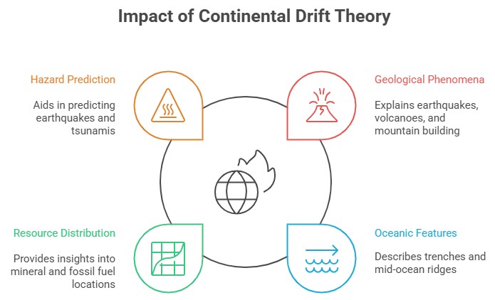
Impact and Significance of the Continental Drift Theory
- The acceptance of the Continental Drift Theory and the development of plate tectonics revolutionized the field of geology and our understanding of Earth's dynamics.
- It explains various geological phenomena such as earthquakes, volcanic activity, mountain building, and the formation of oceanic features like trenches and mid-ocean ridges.
- Plate tectonics provides a framework for understanding the distribution of natural resources, such as minerals and fossil fuels.
- The theory also helps in predicting and understanding natural hazards like earthquakes and tsunamis, aiding in disaster preparedness.
Criticisms and Ongoing Research on the Continental Drift Theory
- While the Continental Drift Theory and plate tectonics are widely accepted, ongoing research continues to refine our understanding of Earth's processes.
- Some scientists are studying the role of mantle plumes and hotspots in plate movement and the influence of other factors like climate change on tectonic processes.
Conclusion
The study of plate tectonics is an active field, and new discoveries are continually contributing to our understanding of Earth's history and its future.
7. Seafloor Spreading: Process, Evidence, Rate, Significance in Plate Tectonics
Seafloor spreading is a geological process that occurs along the oceanic ridges, where new oceanic crust is formed and spread apart from each other. This concept was proposed by Harry Hess in the early 1960s and is a fundamental aspect of plate tectonics theory. Seafloor spreading provides insights into the mechanisms behind continental drift, the formation of oceanic crust, and the movement of Earth's tectonic plates.
Basics of Seafloor Spreading
- Seafloor spreading is a continuous process that takes place along the mid-oceanic ridges, which are long mountain ranges found in the middle of the ocean basins.
- The mid-oceanic ridges are divergent plate boundaries, where tectonic plates move away from each other.
- As the plates move apart, magma from the Earth's mantle rises to fill the gap, creating a new oceanic crust.

Mechanism of Seafloor Spreading
- At the mid-oceanic ridges, tensional forces cause the lithospheric plates to move apart.
- As the plates separate, magma from the asthenosphere (the partially molten layer below the lithosphere) rises to the surface through a process called mantle convection.
- The magma cools upon contact with the cold seawater, solidifying and adding new crust to the edges of the separating plates.
- This process forms symmetrical mirror-image patterns on either side of the ridge, known as magnetic anomalies, due to the Earth's magnetic field.

Evidence for Seafloor Spreading
- The primary evidence for seafloor spreading comes from studies of the oceanic crust and the pattern of magnetic anomalies.
- The Earth's magnetic field has undergone reversals over time, causing magnetic minerals in the oceanic crust to align in different directions.
- When the oceanic crust forms, it preserves the magnetic field's orientation, creating bands of normal and reversed polarity on either side of the mid-oceanic ridges.
- These magnetic anomalies have been mapped and provide a record of the seafloor's spreading history.
- Additionally, studies of rock ages and drilling samples from the ocean floor also support the concept of seafloor spreading.
Rate of Seafloor Spreading
- The rate of seafloor spreading varies in different locations but typically ranges from a few centimeters to a few tens of centimeters per year.
- The fastest spreading rates occur in the East Pacific Rise and the slowest in the Mid-Atlantic Ridge.
- By measuring the age of the oceanic crust and its distance from the ridge, scientists can estimate the average spreading rate over millions of years.
Implications of Seafloor Spreading
- Seafloor spreading is a key component of plate tectonics, explaining the movement and interaction of Earth's tectonic plates.
- The newly formed oceanic crust pushes older crust away from the ridge, leading to the concept of subduction zones where older crust is forced back into the mantle.
- Seafloor spreading contributes to the widening of ocean basins, ultimately influencing the shapes and sizes of the continents.
- The process also influences the distribution of marine life and the formation of hydrothermal vents, which support unique ecosystems.
Significance and Applications of Seafloor Spreading
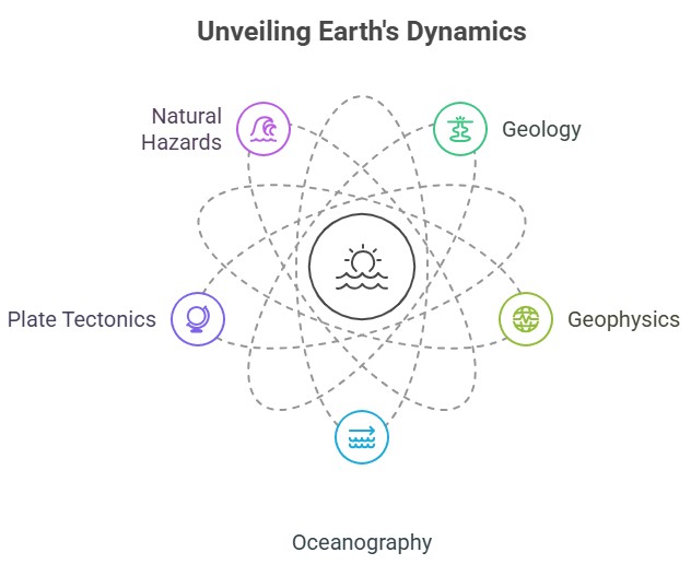
- Understanding sea floor spreading has implications for various fields, including geology, geophysics, and oceanography.
- It provides insights into Earth's history, including the formation of oceans and the breakup of ancient supercontinents.
- The concept of seafloor spreading helps explain the occurrence of earthquakes, volcanic activity, and the formation of mineral deposits associated with mid-oceanic ridges.
- The study of seafloor spreading is crucial for understanding the geodynamic processes that shape our planet and for assessing natural hazards in oceanic regions.
- By comprehensively studying seafloor spreading, scientists have gained a deeper understanding of the dynamic nature of Earth's crust and its impact on geological processes.
- The concept has revolutionized the field of plate tectonics and continues to contribute to our knowledge of Earth's history and ongoing changes.
8. Mapping of the Ocean Floor: Bathymetry, Techniques, and Global Landforms
Mapping of the ocean floor, also known as bathymetry, is a crucial process for understanding the topography, geological features, and ecosystems of the Earth's oceans.

Importance of Mapping of the Ocean Floor
The ocean floor covers more than 70% of the Earth's surface and plays a vital role in regulating climate, supporting marine life, and understanding Earth's geological history.
Accurate mapping helps in identifying underwater features like ridges, trenches, seamounts, and plate boundaries, providing valuable insights into tectonic activity and the formation of natural resources.
Mapping assists in locating potential fishing zones, identifying mineral deposits, and assessing the environmental impact of human activities such as oil and gas exploration, deep-sea mining, and submarine cable installations.
Historical Developments in Mapping of the Ocean Floor
Early attempts at ocean floor mapping were done using lead lines, which provided limited information about the depth but lacked precision.
The advent of echo sounders in the early 20th century allowed for more accurate measurements. Echo sounders emit sound waves and measure the time taken for the sound to reflect back, providing depth information.
Modern Techniques in Mapping of the Ocean Floor
Multibeam Sonar:
Multibeam sonar systems use multiple beams of sound waves to provide detailed bathymetric data.
These systems can cover a wide swath of the seafloor and produce high-resolution maps.
Multibeam sonar data helps in identifying seafloor features, such as underwater mountains, canyons, and sediment distribution.
Satellite Altimetry:
Satellite altimetry measures the height of the sea surface with high precision.
By detecting subtle variations in sea surface height caused by gravitational forces and variations in seafloor topography, it indirectly provides information about the ocean floor.
This technique helps in mapping large-scale features like mid-ocean ridges and major ocean basins.
Remotely Operated Vehicles (ROVs) and Autonomous Underwater Vehicles (AUVs):
ROVs and AUVs equipped with sonar systems and cameras are used for detailed mapping of specific areas or inaccessible regions.
They provide high-resolution imagery and collect data on underwater features, marine life, and geological samples.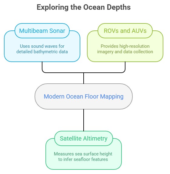
International Efforts in Mapping of the Ocean Floor
The General Bathymetric Chart of the Oceans (GEBCO) is a global initiative to create and provide freely available bathymetric data sets.
The Seabed 2030 project, a collaboration between GEBCO and the Nippon Foundation, aims to map the entire ocean floor by 2030.
Several countries, including the United States, Canada, Japan, and European nations, have their own programs for mapping the ocean floor.
Challenges and Future of Mapping of the Ocean Floor
Mapping the ocean floor is a vast and challenging task due to the sheer size and depth of the oceans.
Technological advancements, such as improved multibeam sonar systems and autonomous underwater vehicles, are enhancing data collection capabilities.
The development of advanced data processing techniques, machine learning algorithms, and artificial intelligence is facilitating faster and more accurate analysis of bathymetric data.
Continued efforts in ocean floor mapping are crucial for understanding marine ecosystems, identifying potential resources, and managing human activities sustainably.
Major Global Landforms
Landforms across the world are diverse and varied, showcasing the Earth's rich geological history and the dynamic processes that have shaped the planet's surface.

North America:
Rocky Mountains: Stretching from Canada to the United States, the Rocky Mountains are a vast mountain range known for their rugged peaks, deep valleys, and scenic landscapes.
Grand Canyon: Located in Arizona, USA, the Grand Canyon is a massive canyon carved by the Colorado River over millions of years, revealing spectacular rock formations and layers.
Great Plains: The Great Plains are vast flatlands covering parts of the United States and Canada, characterized by extensive grasslands and agricultural regions.
South America
Andes Mountains: The Andes, running along the western edge of South America, are the world's longest mountain range, featuring towering peaks, deep valleys, and active volcanoes.
Amazon Rainforest: The Amazon Rainforest, spanning multiple South American countries, is a vast tropical rainforest known for its biodiversity and the mighty Amazon River.
Europe
Alps: The Alps, stretching across several European countries, including Switzerland, France, and Italy, are a famous mountain range known for its picturesque landscapes, snow-capped peaks, and world-renowned ski resorts.
Norwegian Fjords: Along the western coast of Norway, fjords—deep, narrow inlets—carved by glaciers create stunning landscapes of steep cliffs, waterfalls, and calm waters.
Africa
Sahara Desert: The Sahara is the world's largest hot desert, spanning across northern Africa, characterized by vast stretches of sand dunes, rocky plateaus, and arid landscapes.
Mount Kilimanjaro: Located in Tanzania, Mount Kilimanjaro is the highest peak in Africa, featuring distinct volcanic cones and a snow-capped summit.
Asia
Himalayas: The Himalayas, running through several Asian countries, including Nepal, India, and China, are the world's highest mountain range, featuring majestic peaks like Mount Everest and deep valleys.
Gobi Desert: The Gobi Desert, spanning across China and Mongolia, is a vast arid region with a mixture of sand dunes, rocky outcrops, and unique desert landscapes.
Australia and Oceania
Great Barrier Reef: Off the coast of Australia, the Great Barrier Reef is the world's largest coral reef system, showcasing a stunning underwater world with diverse marine life.
Uluru (Ayers Rock): Located in Australia's Northern Territory, Uluru is a massive sandstone monolith and an iconic landmark.
These are just a few examples of the remarkable landforms found across the world. Each continent and region has its own distinctive geological features, reflecting the complex and dynamic processes that have shaped our planet over millions of years.
9. The Hydrosphere & Cryosphere: Earth's Water & Climate Systems
The hydrosphere encompasses all of Earth’s water in oceans, lakes, rivers, ice, and vapor, covering about 70% of the planet’s surface. The cryosphere, its frozen part, plays a crucial role in regulating climate and storing freshwater.
Introduction to the Hydrosphere and the Cryosphere
- The hydrosphere constitutes all of the Earth's water in its various forms, including oceans, seas, lakes, rivers, groundwater, ice, and water vapor in the atmosphere. Covering approximately 70% of the Earth's surface, the hydrosphere plays a crucial role in sustaining life on the planet.
- The hydrosphere's importance cannot be overstated. It regulates temperature, sustains life, influences weather patterns, and supports diverse ecosystems. Moreover, it forms an integral part of Earth's natural recycling system: the hydrological cycle.
Water on the Surface of the Earth in the Hydrosphere
The vast majority of water in the hydrosphere is found in the oceans, which hold about 97.5% of all Earth's water. The remaining 2.5% is freshwater, found in glaciers, ice caps, groundwater, lakes, rivers, and the atmosphere.

- Oceans: They are vast, interconnected bodies of saltwater covering most of the Earth's surface. They are crucial for moderating global climate and host a vast array of biodiversity.
- Freshwater Bodies: These are bodies of water that have low salinity, such as lakes, ponds, rivers, and streams. They play a crucial role in providing water for drinking, irrigation, and power generation.
- Groundwater: This refers to the water present beneath the Earth's surface in soil pore spaces and in the fractures of rock formations. It is a crucial source of water for agriculture and personal use.
- Ice Caps and Glaciers: They store about 69% of the world's freshwater and play a critical role in Earth's climate system.
The Hydrological Cycle of the Hydrosphere
The hydrological or water cycle is a circular system that describes how water evaporates from the surface of the earth, rises into the atmosphere, cools and condenses into clouds, and falls back to the surface as precipitation. The water that falls to Earth may evaporate again or flow into rivers and eventually into the oceans.

Key Processes of the Hydrological Cycle
- Evaporation: This process transforms liquid water into a gaseous state, which then rises into the atmosphere.
- Transpiration: This is the evaporation of water from plants through their leaves.
- Condensation: As the water vapor rises, it cools and transforms back into liquid form, creating clouds.
- Precipitation: When the cloud particles become too heavy to remain suspended in the cloud, they fall to Earth as rain, snow, sleet, or hail.
- Runoff and Infiltration: Water that reaches the Earth's surface often flows over the surface as runoff, eventually collecting in bodies of water. Some of this water also infiltrates or percolates into the ground and becomes groundwater.
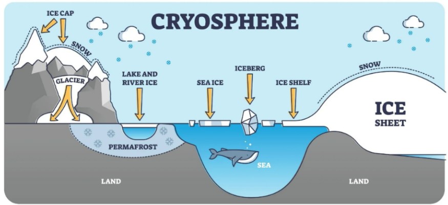
Cryosphere: The Icy Component of the Hydrosphere
- The cryosphere is a term derived from the Greek word 'kryos', meaning cold or ice.
- It refers to the component of the Earth's system that consists of frozen water – in glaciers, ice caps, icebergs, sea ice, snow, and permafrost. The cryosphere is an integral part of the hydrosphere and plays a vital role in the Earth's climate system.
- Snow and ice, due to their light color, reflect a significant amount of sunlight back into space, which helps regulate the Earth's temperature. In addition, the cryosphere stores about three-quarters of the world's freshwater.
- The cryosphere's health is a key indicator of global climate trends. The ongoing reduction in the size of the world's ice masses is one of the most visible indicators of global climate change.
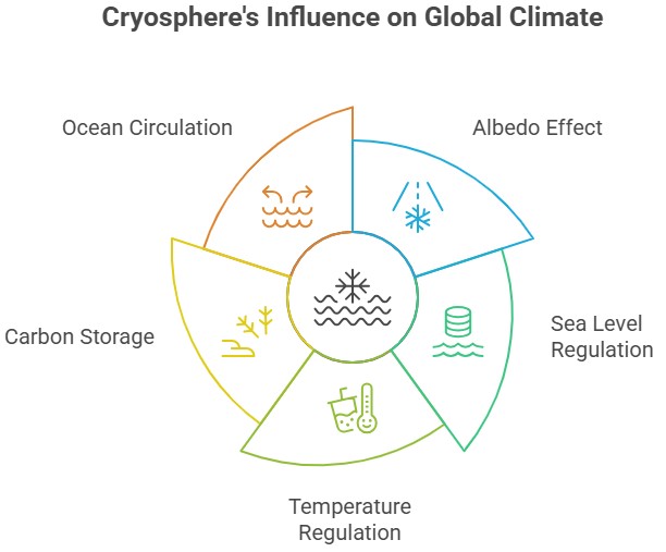
Impact of Cryosphere on Global Climate
- Albedo Effect: One of the most significant contributions of the cryosphere to the global climate system is the albedo effect. Ice and snow, due to their light color, reflect a significant amount of solar radiation back into space (around 80-90%), which helps to regulate the Earth's temperature. As the cryosphere diminishes due to climate change, this reflective capacity decreases, leading to increased absorption of solar radiation and further warming—a phenomenon known as a positive feedback loop.
- Sea Level Regulation: The cryosphere plays a critical role in regulating sea levels. Glaciers and ice sheets store massive amounts of water; when these ice masses melt due to rising global temperatures, the water flows into the world's oceans, contributing to sea level rise. For instance, if all the ice in the Greenland ice sheet melted, it could cause sea levels to rise by about 7 meters, dramatically impacting coastal communities worldwide.
- Temperature Regulation: The cryosphere can help to regulate temperatures. Ice and snow require significant amounts of energy to change temperature (high heat capacity), meaning they can help to moderate Earth's climate by absorbing heat in the summer and releasing it in the winter.
- Carbon Storage: Permafrost, frozen ground in the cryosphere, stores a large amount of carbon—more than twice as much carbon as is currently in the atmosphere. As global temperatures rise and permafrost thaws, this carbon can be released as methane and carbon dioxide, potent greenhouse gases that contribute to further climate warming—a process known as the permafrost carbon feedback.
- Ocean Circulation: The cryosphere also impacts global ocean circulation. When sea ice forms, it expels salt into the surrounding water, making it denser and causing it to sink. This process helps drive thermohaline circulation, a global 'conveyor belt' of ocean currents that redistributes heat around the planet and influences climate.
Conclusion
The cryosphere significantly impacts the global climate, and changes to it due to anthropogenic climate change can have far-reaching implications for weather patterns, sea levels, and the livability of many parts of the world. The relationships between the cryosphere, oceans, atmosphere, and biosphere underscore the complexity and interconnectivity of Earth's climate system.
10. Earth's Heat Budget: Energy Balance, Greenhouse Effect, and Climate Change
Heat budget, also known as the Earth's energy budget, refers to the balance between incoming and outgoing energy in the Earth's atmosphere. It is essential for understanding the climate system and how energy is distributed and exchanged within the Earth's system.

Energy Sources in the Heat Budget
- The Sun is the primary source of energy for the Earth. It emits electromagnetic radiation, primarily in the form of visible light, which travels through space and reaches the Earth's atmosphere.
- Other sources of energy include geothermal energy (heat from the Earth's interior) and tidal energy (resulting from gravitational interactions with the Moon and the Sun). However, these sources contribute only a small fraction to the Earth's heat budget compared to solar radiation.
Solar Radiation in the Heat Budget
- Solar radiation is the energy emitted by the Sun and reaches the Earth's atmosphere as sunlight.
- About 30% of the incoming solar radiation is reflected back into space by clouds, aerosols, and the Earth's surface. This reflected energy is called albedo.
The remaining 70% of the solar radiation is absorbed by the Earth's surface, oceans, and atmosphere, leading to an increase in temperature.
Absorption and Redistribution in the Heat Budget
- Different components of the Earth's system absorb solar radiation to varying degrees. For instance, the atmosphere primarily absorbs shorter-wavelength solar radiation, particularly in the ultraviolet (UV) range.
- The Earth's surface, including land, water bodies, and ice, absorbs longer-wavelength solar radiation, mostly in the visible and infrared (IR) range. Once absorbed, the energy is redistributed through various processes such as conduction, convection, evaporation, and radiation.
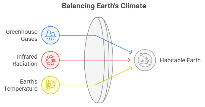
Greenhouse Effect and the Heat Budget
- The Earth's atmosphere contains greenhouse gases (e.g., carbon dioxide, methane, water vapor) that absorb and re-emit some of the outgoing infrared radiation, trapping heat in the atmosphere. This is known as the greenhouse effect.
- The greenhouse effect is vital for maintaining the Earth's average temperature at approximately 15°C (59°F), making it habitable for life as we know it. Without this effect, the average temperature would be much colder, around -18°C (0°F).
Outgoing Radiation in the Heat Budget
- The Earth's surface, oceans, and atmosphere emit infrared radiation (longwave radiation) as a result of their temperatures. This outgoing radiation carries heat energy away from the Earth.
- Some of this outgoing radiation escapes directly to space, while a significant portion is absorbed and re-emitted by greenhouse gases in the atmosphere. Eventually, the remaining energy exits the atmosphere and is radiated into space.
Energy Imbalances in the Heat Budget
- The Earth's heat budget can experience imbalances, resulting in changes in global temperature over time.
- Positive energy imbalance occurs when more energy is absorbed than emitted, leading to a net gain in heat. This can contribute to global warming and climate change.
- A negative energy imbalance occurs when more energy is emitted than absorbed, leading to a net loss in heat. This can cause cooling effects, such as during volcanic eruptions when aerosols block incoming solar radiation.
Monitoring and Research
- Scientists use various instruments, satellites, and models to measure and monitor the components of the Earth's energy budget, including solar radiation, albedo, greenhouse gases, and outgoing radiation.
Conclusion
Understanding the heat budget helps scientists study climate patterns, predict weather phenomena, and assess the impacts of human activities on the Earth's climate system.
It's important to note that the Earth's heat budget is a complex system influenced by numerous factors, and ongoing research and monitoring are necessary to improve our understanding of its intricacies and implications for global climate change.
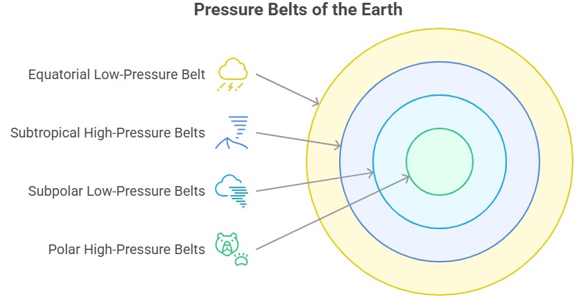
11. Pressure Belts of the Earth: Types, Features & Importance in Climate
Pressure belts refer to the global patterns of atmospheric pressure that exist on Earth's surface. These belts are formed due to the distribution of solar energy received by different regions and the rotation of the Earth. Understanding pressure belts is crucial in comprehending global weather patterns and the movement of air masses.

Equatorial Low-Pressure Belt
- Also known as the Doldrums, it is located near the equator, between the Tropic of Cancer and the Tropic of Capricorn.
- It is characterized by low atmospheric pressure due to intense solar heating, causing warm air to rise and create a zone of low pressure.
- Rising air cools, condenses, and produces abundant rainfall, making this region prone to thunderstorms and heavy precipitation.
Subtropical High-Pressure Belts
- Found around 30 degrees latitude in both hemispheres, known as the subtropics.
The descending air from higher altitudes creates high pressure, resulting in stable and dry conditions. - These belts are responsible for the formation of arid regions such as the Sahara Desert in Africa and the Mojave Desert in North America.
Subpolar Low-Pressure Belts
- Situated around 60 degrees latitude in both hemispheres.
- These low-pressure areas are a consequence of the convergence of polar air masses with warmer air masses from the mid-latitudes.
- Characterized by stormy weather, strong winds, and abundant precipitation, especially in coastal areas.
- Play a vital role in the formation and movement of mid-latitude cyclones.
Polar High-Pressure Belts
- Located near the poles, around 90 degrees latitude in both hemispheres.
- Extremely cold temperatures cause air to descend, resulting in high pressure.
- These belts are associated with extremely dry and stable atmospheric conditions, with little precipitation.
Intertropical Convergence Zone (ITCZ)
- Also known as the doldrums, it is a shifting belt near the equator where the northeast and southeast trade winds meet.
- The convergence of trade winds creates a zone of low pressure and abundant rainfall.
The ITCZ shifts seasonally, following the migration of the sun.
Polar Front
- A dynamic boundary separating cold polar air from warmer mid-latitude air.
- It is an area of significant temperature contrast, leading to the development of low-pressure systems and stormy weather.
- The polar front is associated with the formation of extratropical cyclones.
Pressure Gradient
- Refers to the rate of change of atmospheric pressure over a given distance.
- Air moves from regions of higher pressure to lower pressure due to the pressure gradient force.
- The strength of the pressure gradient affects wind speed, with stronger gradients resulting in faster winds.
Conclusion
Understanding pressure belts helps meteorologists and climatologists predict weather patterns, track storm systems, and analyze global climate phenomena like El Niño and La Niña. These belts, along with other factors such as ocean currents and topography, influence the climate and weather conditions experienced across different regions of the world.
12. Understanding Air Masses and Their Impact on Macro Climatic Changes
Air masses are vast bodies of air with uniform temperature and moisture characteristics that influence weather and climate over large areas. Their formation, movement, and interaction play a vital role in shaping macro climatic patterns across the globe. Understanding air masses is essential for analyzing weather systems and long-term climate changes.
Air Mass and its Impact on Macro Climatic Changes

Air Mass
- An air mass is a large body of air with relatively uniform temperature and moisture characteristics.
- It covers an extensive geographic area and has a distinct source region.
Air masses are classified based on their temperature and moisture characteristics. - The temperature classification includes polar (P) air masses, which are cold, and tropical (T) air masses, which are warm. The moisture classification includes maritime (m) air masses, which are humid, and continental (c) air masses, which are dry.
Formation of Air Masses
- Air masses form primarily due to the stagnation and stability of air over a source region for an extended period.
- The source regions are typically large and relatively uniform areas over which an air mass acquires its temperature and moisture properties.
- Polar air masses form near the poles and are cold and dry, while tropical air masses form near the equator and are warm and moist.
- Maritime air masses form over oceans, acquiring moisture and maintaining relatively high humidity levels, while continental air masses form over land, resulting in lower humidity levels.
Characteristics of Air Masses
- Continental Polar (cP): These air masses form over polar regions and bring cold, dry air. They are responsible for cold winters in many mid-latitude regions.
- Maritime Polar (mP): These air masses form over the ocean in higher latitudes. They bring cool, moist air and often result in cloudy and damp conditions.
- Continental Tropical (cT): These air masses form over hot desert regions and bring hot, dry air. They are responsible for heat waves in many regions.
- Maritime Tropical (mT): These air masses form over warm oceanic regions near the equator. They bring warm, humid air and are associated with heavy rainfall and thunderstorms.
Role in Macro Climatic Changes
- Air masses play a significant role in macro climatic changes by influencing weather patterns over large geographic areas.
- When an air mass moves from its source region, it affects the characteristics of the region it encounters. The interaction between different air masses leads to the formation of weather fronts, which are boundaries separating air masses of different properties.
- Frontal systems associated with air masses are responsible for the development of various weather phenomena, such as precipitation, temperature changes, and cloud formation.
- The movement of air masses is influenced by prevailing winds, such as the polar jet stream and trade winds. These winds help transport air masses across continents and oceans, contributing to the global distribution of weather patterns.
- The collision of contrasting air masses along fronts can lead to the formation of severe weather conditions, including thunderstorms, tornadoes, and cyclones.
- Air masses also influence the overall climate of a region. For example, the prevalence of maritime tropical air masses can lead to a warm and humid climate, while the dominance of continental polar air masses can result in colder and drier conditions.
- Long-term shifts in the distribution and characteristics of air masses can contribute to climate change and the alteration of macro climatic patterns.
Conclusion
Understanding air masses and their role in macroclimatic changes is crucial for meteorologists and climatologists in predicting weather patterns, studying climate dynamics, and assessing the potential impact of climate change on different regions.
13. Monsoon Climate: Characteristics, Importance, Role of Atmospheric Layers
Monsoon climate is a distinct climatic pattern characterized by seasonal changes in wind direction and precipitation. It is commonly experienced in several regions around the world, including South and Southeast Asia, parts of Africa, and northern Australia.

Characteristics of Monsoon Climate
- Monsoons feature seasonal wind reversal: warm, onshore winds in summer and cool, offshore winds in winter.
- Monsoon climates have distinct wet (summer) and dry (winter) seasons.
- Regional monsoon variations exist, such as single or double monsoon seasons.
- These climates show seasonal temperature shifts due to changing moisture levels.
- Monsoons greatly affect agriculture, both positively (rainfall for crops) and negatively (droughts, excessive rainfall).
- Monsoon climates support diverse ecosystems affecting the lifecycle of flora and fauna.
- The timing and distribution of monsoon rains can significantly impact socioeconomic factors.
- Monsoons show interannual and decadal variability due to factors like ENSO and IOD, and climate change may further alter these patterns.
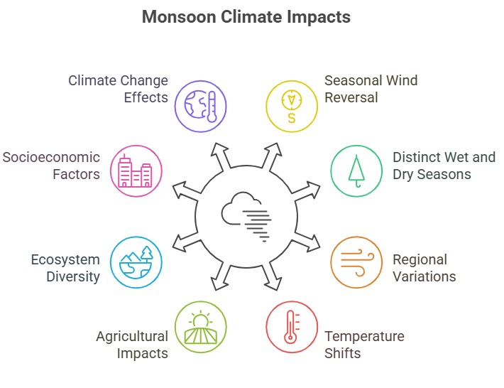
Conclusion
It is important to note that while these characteristics generally define monsoon climates, there can be variations within specific regions and localities. Factors such as topography, proximity to oceans, and geographic location contribute to the unique features of each monsoon region.
Role of Various Layers of the Atmosphere in Weather Processes

- Troposphere: This layer, 7-20 km above Earth, hosts weather phenomena, with temperatures decreasing as altitude increases. Key weather processes include convection, cloud formation, and precipitation.
- Stratosphere: Positioned 20-50 km above Earth, temperatures increase with altitude. It contains the ozone layer which absorbs UV radiation, impacting temperature distribution and weather patterns. Also, it houses jet streams influencing the movement of weather systems.
- Mesosphere: Extending from 50-85 km above Earth, the mesosphere's temperatures decrease with altitude and it hosts noctilucent clouds, indicators of atmospheric conditions.
- Thermosphere: This layer, from 85 km to space, exhibits increasing temperatures due to solar radiation absorption. It facilitates ionization, creating charged particles that interact with Earth's magnetic field to create auroras. It also contributes to Earth's overall energy balance.
Conclusion
It's important to note that the different layers of the atmosphere are not strictly isolated from each other. They interact and influence one another, creating a complex system that shapes weather processes on Earth.
14. Impact of Climate on Desertification
Introduction:
Climate plays a crucial role in the process of desertification, which refers to the expansion of desert-like conditions into non-desert areas. Desertification is influenced by a combination of climatic, ecological, and human factors.
Factors of Climate Impacting Desertification:
- Aridity: Climate change affects precipitation patterns, increasing dryness and driving desertification, particularly in regions with low rainfall and high evaporation.
- Droughts: Increasing frequency and severity of droughts due to climate change exacerbate desertification by reducing soil moisture and promoting erosion.
- Temperature Increase: Rising global temperatures enhance soil moisture deficits through increased evaporation, leading to agricultural land degradation and desertification.
- Precipitation Patterns: Alterations in rainfall timing, intensity, and distribution can disrupt ecosystems, increasing vulnerability to desertification.
- Wind Patterns: Climate change can shift wind patterns, escalating desertification through increased sediment transport and soil nutrient loss.
- Sea-Level Rise: Higher sea levels can cause saltwater intrusion, making agricultural lands unsuitable for cultivation and contributing to desertification.
- Feedback Loops: Desertification can generate positive feedback loops, reducing local humidity and cloud formation, leading to drier conditions.
|
Key Reports on Desertification:
|
Way Forward:
Addressing desertification requires a combination of climate change mitigation strategies, sustainable land management practices, reforestation efforts, water conservation, and international cooperation. These efforts aim to restore degraded ecosystems, enhance soil health, promote resilient agricultural practices, and reduce greenhouse gas emissions to mitigate the impacts of climate change.
Conclusion:
It's important to note that while climate change is a significant driver of desertification, human activities, such as overgrazing, deforestation, unsustainable land management practices, and inappropriate irrigation methods, often interact with climate factors and accelerate the process.
15. Temperature Inversion: Causes, Impacts & Meteorological Significance
Temperature inversion refers to a meteorological phenomenon in which the temperature of the atmosphere increases with altitude, contrary to the normal decrease in temperature with height. In this case, a layer of warm air is trapped above a layer of cooler air near the Earth's surface, leading to an inversion of the usual temperature profile. Temperature inversions can occur in various atmospheric conditions and have both natural and human-induced causes. They can have significant impacts on weather, air quality, and human activities.
Causes of Temperature Inversion
- Radiation Inversion: Also known as nocturnal inversion, it occurs during clear and calm nights when the Earth's surface loses heat rapidly by radiation. This causes the air near the ground to cool, leading to a temperature inversion.
- Subsidence Inversion: This type of inversion occurs when a large-scale sinking motion in the atmosphere results in the compression and warming of the air. As the air sinks, it becomes more stable, leading to the formation of a temperature inversion.
- Frontal Inversion: Temperature inversions can develop along the boundaries between air masses with contrasting temperatures. When a warm air mass overrides a cooler air mass, it forms a frontal inversion.
- Advection Inversion: Advection refers to the horizontal movement of air. If warm air is advected over a cooler surface, such as a cold ocean current or a snow-covered area, a temperature inversion can form.

Impacts of Temperature Inversion
- Air Pollution Trapping: Temperature inversions can trap pollutants close to the ground, resulting in poor air quality with potential adverse health and environmental effects.
- Fog Formation: Inversions often create conditions for fog and low-level clouds, impacting transportation and visibility.
- Temperature Gradient Disruption: Inversions disrupt the typical vertical temperature gradient in the atmosphere, affecting weather patterns and cloud formation.
- Frost Formation: In winter, inversions can cause frost and freezing conditions due to persistent colder temperatures near the surface.
- Impact on Agriculture: Inversions increase frost risk, potentially damaging crops and agricultural productivity.
- Temperature Disparities: Inversions can cause significant temperature variations between locations, leading to localized climate anomalies.
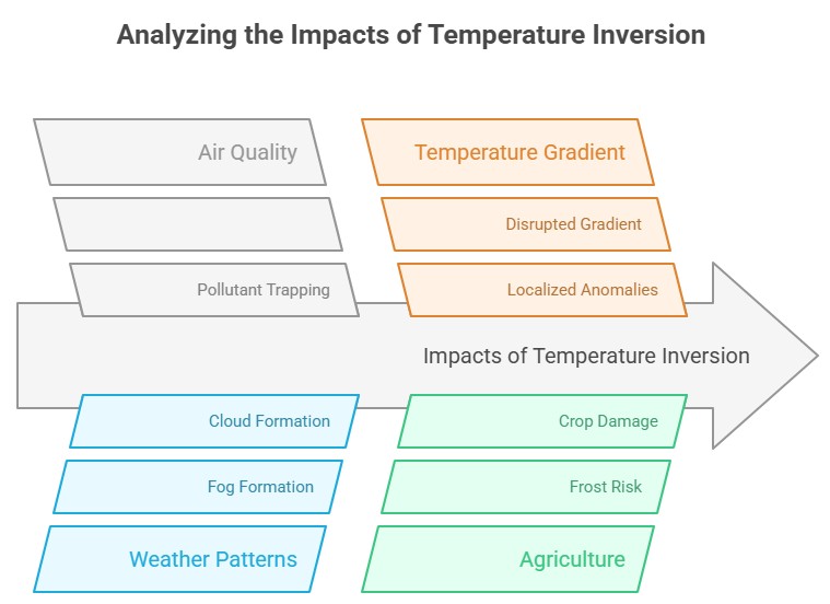
Conclusion
Understanding temperature inversions and their causes and impacts is crucial for various sectors, including meteorology, air quality management, agriculture, and transportation. Monitoring and predicting temperature inversions can help mitigate their adverse effects and improve planning and decision-making processes related to weather and environmental conditions.
16. Heat Islands
Introduction:
Heat islands refer to urban areas that experience significantly higher temperatures compared to their surrounding rural areas. This phenomenon is primarily caused by human activities and the built environment. Heat islands have numerous negative impacts on human health, energy consumption, and the environment. In this comprehensive set of notes, we will explore the causes, effects, mitigation strategies, and potential solutions to combat the heat island effect.
Causes of Heat Islands:
- Urbanization: The transformation of natural landscapes into cities and towns results in the replacement of vegetation with buildings, roads, and concrete, which absorb and re-emit heat.
- Modification of land surfaces: Paving, asphalt, and concrete surfaces, which have low albedo (reflectivity), absorb and retain solar radiation, leading to increased temperatures.
- Lack of vegetation: Reduced green spaces, trees, and vegetation in urban areas limit shade and the cooling effect of evapotranspiration.
- Human activities: Heat-generating activities such as industrial processes, vehicle emissions, air conditioning systems, and waste heat from buildings contribute to the overall heat load.
Effects of Heat Islands:
- Human health impacts: Heat islands contribute to heat-related illnesses and mortality, particularly among vulnerable populations such as the elderly, children, and those with pre-existing health conditions.
- Increased energy demand: Higher temperatures in urban areas lead to increased demand for cooling, resulting in higher energy consumption and associated costs.
- Environmental consequences: Heat islands exacerbate air pollution, water pollution, and the formation of smog. They disrupt local ecosystems, alter rainfall patterns, and affect wildlife habitats.
- Reduced urban comfort: Heat islands diminish outdoor comfort, making it challenging to engage in physical activities and reducing quality of life.
Mitigation Strategies for Heat Islands:
- Incorporate more green spaces in urban design to reduce surface temperatures.
- Use cool materials and green roofs in urban structures to reflect sunlight.
- Enhance building insulation and employ energy-efficient technologies.
- Educate communities about the heat island effect and mitigation actions.
- Regularly monitor temperature variations and conduct research for mitigation strategies.
- Foster collaborations among policymakers, researchers, and communities for effective heat island reduction strategies.
Conclusion:
The heat island effect poses significant challenges to urban areas, impacting human health, energy consumption, and the environment. However, with a comprehensive approach involving urban planning, vegetation, resilient infrastructure, and community engagement, it is possible to mitigate the heat island effect and create sustainable, livable cities for the future.
17. Heat Dome
Introduction
Several countries in Europe experienced record-breaking temperatures in January, with temperatures 10 to 200C above average. This phenomenon was attributed to the formation of a heat dome over the region. Heat domes have become more frequent and intense in recent years, causing deadly heat waves.
Heat Dome
- A heat dome occurs when an area of high-pressure traps warm air over a region for an extended period, similar to a lid on a pot.
- Trapped air gets heated by the sun over time, resulting in increasingly warm conditions.
- Heat domes typically last for a few days but can persist for weeks, leading to deadly heat waves.
- Air sinking under high pressure gets compressed, becoming even warmer, and drier, further raising temperatures.
Heat Domes and the Jet Stream
- Jet streams are narrow bands of strong wind in the upper atmosphere.
- The jet stream has a wave-like pattern that oscillates between north and south.
- When these waves become elongated and stationary, high-pressure systems get stuck, forming a heat dome.
- Climate change may be intensifying heat domes by increasing the waviness of the jet stream, resulting in more frequent extreme heat events.

Causes of Formation of Heat Dome
- Change in Ocean Temperature
- A strong change or gradient in ocean temperatures initiates the heat dome formation process.
- Convection occurs, with warm air rising over the ocean surface due to the temperature gradient.
- Prevailing winds carry the hot air eastward, while shifts in the jet stream trap and move it toward land, where it sinks, leading to heat waves.
- Change in Atmospheric Pressure
- Heat waves begin when high-pressure systems in the atmosphere push warm air toward the ground.
- Heat rising from the ocean fuels this effect, creating an amplification loop.
- The high-pressure system expands vertically, altering the course of other weather systems, reducing wind and cloud cover, and prolonging the heat wave.
- Climate Change
- Rising temperatures caused by global warming contribute to hotter weather conditions.
- While heat waves have always occurred naturally, climate change has amplified their intensity, duration, and frequency.
- Scientists studying the climate agree that human-induced climate change plays a significant role in the occurrence of heat waves.
18. Coral Reefs
Coral reefs are intricate ecosystems built by thousands of small animals known as coral polyps, which are closely related to anemones and jellyfish.
Formation of Coral Reefs
- Coral polyps have soft bodies covered by calcareous skeletons that they create by extracting calcium salts from seawater. These polyps live in colonies attached to the rocky sea floor.
- The tubular skeletons grow upwards and outwards, forming a cemented calcareous rocky mass collectively known as corals. When coral polyps die, they shed their skeletons, which serve as the foundation for new polyps to grow.
- Over millions of years, this cycle repeats, resulting in the accumulation of coral layers, known as reefs. Different stages of coral deposition give rise to various marine landforms, with coral reefs being one of the most important.
Types of Coral Reefs
Ideal Conditions and Ecological Causes
- Coral reefs thrive under stable climatic conditions with perpetually warm tropical waters (around 20°C). They require shallow depths for sufficient sunlight, clear saltwater, abundant plankton, and minimal pollution.
- The growth of corals is facilitated by a symbiotic relationship with zooxanthellae, single-cell algae that live within coral polyp tissues.
- Coral bleaching, which can lead to coral death, can occur due to various disturbances such as temperature changes, subaerial exposure, freshwater dilution, inorganic nutrients, xenobiotics, and epizootics.
- Bleaching can be beneficial under low-stress conditions, as corals may develop resistance.
Spatial and Temporal Range of Coral Reef Bleaching
- Coral bleaching events have been observed in major coral reef regions worldwide, including the Caribbean/western Atlantic, eastern Pacific, central and western Pacific, Indian Ocean, Arabian Gulf, and Red Sea.
- Prior to the 1980s, most coral mortality was due to non-thermal disturbances, but since then, bleaching events have occurred on a larger scale and at greater depths.
- Recent research suggests that corals exposed to low levels of stress may develop resistance to bleaching.
19. Tides: Types, Gravitational Forces, Importance, and Renewable Energy
Tides are long-period waves that roll around the planet as the ocean is pulled by the moon's and sun's gravitational forces. They are the rise and fall of sea levels caused by the combined effects of the gravitational forces exerted by the Moon, the Sun, and the rotation of the Earth.
- Tides are driven primarily by the gravitational interaction between Earth and the Moon, with the Sun also playing a smaller but significant role.

Relationship Between Gravitational Forces and Tides
- The creation of tides involves a delicate interplay between the gravitational forces of the Earth, Moon, and Sun. While gravity acts to pull objects toward one another, the centrifugal force acts to push them apart.
- The Moon's gravitational pull is strongest on the side of the Earth that happens to be facing the Moon, causing the water in the oceans to bulge out in the direction of the moon. T
- his creates a high tide. At the same time, another high tide occurs on the opposite side of the Earth due to the centrifugal force created by the Earth spinning on its axis. The areas in between these bulges experience low tide.
- The position of the Sun relative to the Moon and Earth also influences the tides.
- When the Moon and Sun align (at the new moon or full moon), their gravitational forces combine to create higher high tides and lower low tides, known as spring tides.
- When the Moon and Sun are at right angles to each other (first quarter and last quarter moon), their gravitational forces partially cancel each other out, resulting in neap tides, where the difference between high and low tides is smallest.

Tidal Currents
- Tidal currents are the horizontal movement of water caused by the rising and falling of the tides. As the tide rises, water moves towards the coast, causing a "flood current."
- Conversely, as the tide falls, water moves back towards the sea, causing an "ebb current." In some locations, there is a period of little or no current at high or low tide, known as "slack water."
Types of Tides
Based on Frequency
Tides can be categorized based on their frequency:
- Semi-diurnal Tides: These occur twice daily and are common in the Atlantic Ocean. They result in two nearly equal high tides and two low tides each day.
- Diurnal Tides: These occur once daily and are common in some locations in the Gulf of Mexico and the western Pacific Ocean. They result in one high tide and one low tide each day.
- Mixed Tides: These occur twice daily and are common in the Pacific Ocean. They result in two unequal high tides and two unequal low tides each day.
Based on the Sun, Moon, and Earth (SME) Position
Tides can also be categorized based on the relative positions of the Sun, Moon, and Earth:
- Spring Tides: Spring tides occur when the Sun, Moon, and Earth are aligned (during the full moon and new moon). The combined gravitational effect of the Moon and Sun leads to higher high tides and lower low tides.
- Neap Tides: Neap tides occur when the Sun and Moon are at right angles to each other (during the first and last quarter moon). The gravitational forces partially cancel each other out, resulting in less extreme tides.

Importance of Tides
Tides have a significant impact on our planet and daily life. They influence coastal ecosystems, assist in navigation, influence human activities like fishing and surfing, and even have potential for renewable energy generation.
- Ecological Importance: Tides are crucial to the health of many coastal and marine ecosystems. They influence the distribution of organisms, nutrients, and oxygen in these ecosystems, and they create unique habitats like intertidal zones, which support a wide variety of life forms.
- Navigation: For hundreds of years, tides have played a crucial role in navigation. Knowledge of tides is essential for safe and efficient navigation, particularly in coastal waters.
- Fishing and Recreation: Tides can influence the best times for fishing and surfing. Certain fish are more active during particular tide stages, and tidal currents can create ideal wave conditions for surfing.
- Renewable Energy: Tidal movements hold potential for renewable energy generation. Tidal energy is predictable and can generate significant power. Tidal turbines and tidal barrage power plants are two examples of how we can harness this energy.
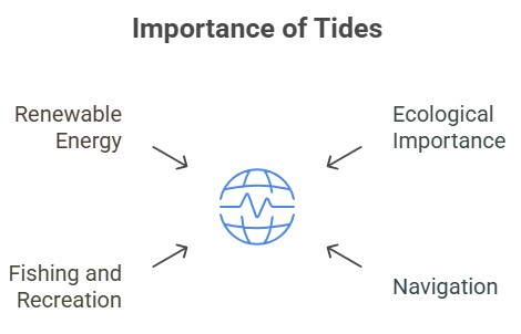
Conclusion
Tides are a complex yet fascinating phenomenon resulting from the gravitational interactions between the Earth, Moon, and Sun. Their impact extends beyond the simple rise and fall of sea levels, influencing diverse ecological systems, human activities, and even renewable energy production.
20. Marine Coastal Ecosystems: Types, Importance, Threats & Conservation
Marine coastal ecosystems are dynamic zones where land meets the ocean, hosting diverse habitats like mangroves, coral reefs, and estuaries. They play a vital role in supporting biodiversity, regulating climate, and sustaining human livelihoods.
Introduction to Marine Coastal Ecosystems
- Marine ecosystems are aquatic environments with high dissolved salt concentrations, such as those found in or near the ocean. Marine ecosystems are defined by their unique biotic (living) and abiotic (nonliving) components.
- Biotic components: Plants, animals, and bacteria
- Abiotic components: quantity of sunlight in the environment, the amount of oxygen and nutrients dissolved in the water, proximity to land, depth, and temperature.
- Coastal ecosystems occur where land meets sea and contain a varied range of habitat types such as mangroves, coral reefs, seagrass beds, estuaries and lagoons, backwaters, and so on.
Types of Marine Coastal Ecosystems
- Estuaries: These are coastal zones where oceans and rivers meet, allowing nutrients and salts to mix. These areas are highly productive and support various life forms.
- Estuaries have historically supported human communities and activities like fishing, shipping, and transportation due to their location near the ocean's boundary.
- Salt marshes: These are the zones where oceans and land meet, are rich in nutrients from sediment. They are flooded by high tides, causing soil to be wet and salty, resulting in low oxygen and decomposing matter. These ecosystems are dominated by low-growing shrubs and grasses.
- Mangrove forest: Mangrove forests, located in tropical regions, are submerged in ocean water, providing habitat for various species. Their root systems filter out salt and oxygen, while the canopy houses birds and other animals. Mangroves also serve as nesting sites for birds.
- Coral Reefs: Coral reefs, euphotic-zone ecosystems in tropical seas, are built from exoskeletons secreted by coral polyps. These diverse ecosystems host sponges, crustaceans, mollusks, fish, turtles, sharks, dolphins, and other creatures, accounting for a quarter of all ocean species.
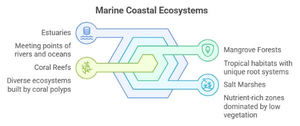
Significance of Marine Coastal Ecosystems
- Marine ecosystems offer numerous benefits to the natural world and humans, including climate regulation, water cycle maintenance, biodiversity conservation, food and energy resources, and recreation and tourism opportunities.
- Further it also supports billions of dollars in economic activities like fisheries, aquaculture, offshore oil and gas, and trade. These ecosystem services can be categorized into supporting, provisioning, regulating, and cultural services.
Threats to Marine Coastal Ecosystems
- Human Exploitation: Coastal marine ecosystems face population pressures, with 40% of the world living within 100 km. Overfishing and global fisheries landings cause biodiversity decline, impacting large species and narrow geographic ranges, contributing to climate change.
- Marine Pollution: Marine pollution from a variety of causes, such as industrial discharge, agricultural runoff, sewage, oil spills, and marine debris, poses a serious danger to coastal ecosystems. Contaminants in the water and sediments can build, compromising the health and reproductive success of marine creatures.
- Climate Change: Rising sea temperatures, ocean acidification, and sea-level rise all pose substantial challenges to marine coastal ecosystems as a result of climate change. Coral bleaching, lower calcification rates in shell-building creatures, changed ocean currents, and shifts in species distribution can all result from these changes.
- Invasive Species: Non-native species introduced by ballast water discharge, aquaculture, and shipping operations can have a negative impact on coastal ecosystems. Invasive species have the potential to outcompete native species, change habitat structure, and disrupt ecosystem function.
Way Forward
- The establishment of a network of well-managed marine protected areas can aid in the protection of vital coastal ecosystems and the recovery of fragile species.
- By enacting rules, advocating eco-friendly designs, and incorporating nature-based solutions such as green infrastructure and living shorelines, sustainable coastal development reduces habitat damage and environmental consequences.
- Climate change mitigation is critical for the long-term health of marine coastal ecosystems. This includes lowering greenhouse gas emissions by switching to renewable energy, boosting energy efficiency, and supporting international climate change accords.
- Encouraging collaboration among governments, coastal communities, researchers, non-governmental organizations, and other stakeholders in order to establish integrated coastal management plans, and promoting effective governance of marine coastal ecosystems.
Marine Deposits in Marine Coastal Ecosystems
- Sources of Marine Deposits: Marine deposits originate from various sources, including sediments brought by rivers, weathering due to wave actions, wind-blown dust, submarine erosion, marine life decomposition, extraterrestrial sources (meteorites), and volcanic activities.
21. Marine Pollution: Causes, Impacts, Dead Zones & Global Solutions
Marine pollution, the introduction of substances or energy into the oceans and seas, is an alarming and growing issue. It not only threatens marine life but also endangers human health, disrupts ecosystems, and stifles the economy.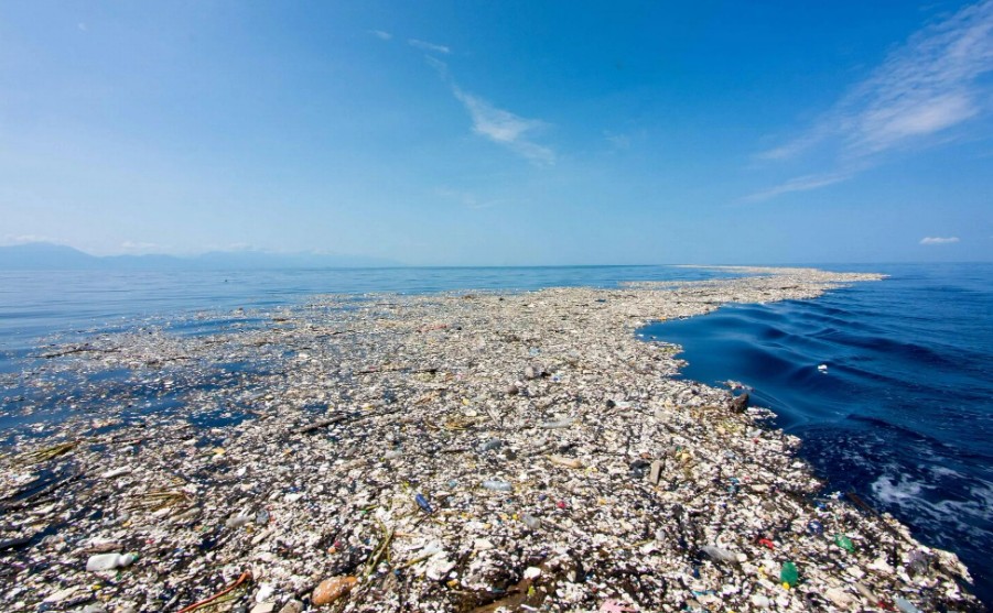
Causes of Marine Pollution
- Direct Discharge: Direct discharge is a major cause of marine pollution. Wastewater, sewage, and garbage from homes and industries often find their way directly into the sea without any treatment, contaminating the waters with various pollutants.
- Land Runoff: Land runoff happens when water from rain or melting snow carries pollutants from the land into the ocean. These pollutants can include pesticides, fertilizers, and other chemicals from agricultural areas, or oil, grease, and toxic chemicals from urban areas.
- Air Pollution: Air pollution is another significant cause. Particulate matter and chemicals from industrial emissions can fall directly into the ocean or be carried there by wind currents.
- Deep-sea Mining and Oil Spills: Deep-sea mining and oil spills also contribute significantly to marine pollution. Mining activities release heavy metals into the sea, while oil spills introduce large volumes of petroleum products. Notable incidents like the Deepwater Horizon oil spill in 2010 released an estimated 4.9 million barrels of oil into the Gulf of Mexico, causing significant damage to marine life.
- Plastic Waste: Plastic waste is another significant contributor. An estimated 8 million tons of plastic waste enter the oceans each year, as per data from the United Nations. This waste takes hundreds of years to decompose, during which time it can harm marine animals and birds and degrade marine ecosystems.
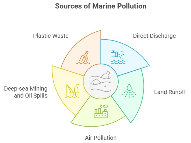
Impacts of Marine Pollution
- Loss of Biodiversity: Pollutants can cause direct mortality in marine species, or they can affect reproduction, leading to long-term declines in populations.
- Damage to Coral Reefs: Coral reefs, vital marine ecosystems, are particularly susceptible to pollution. According to a 2021 report by the United Nations, 50% of the world's coral reefs have died in the last 30 years, and 90% could die within the next century unless urgent action is taken.
- Bioaccumulation: Toxic substances like heavy metals and persistent organic pollutants can accumulate in marine organisms and then move up the food chain, leading to health risks for humans who consume contaminated seafood.
- Ocean Acidification: Increased CO2 emissions are not only causing global warming but are also leading to ocean acidification, which harms shell-building animals and other marine life.
Counter Strategies to Control Marine Pollution
- Strict Laws and Regulations: Stronger enforcement of laws against illegal dumping in the ocean and stricter standards for wastewater treatment can reduce the direct discharge of pollutants.
- Promoting Sustainable Practices: Encourage sustainable farming and industrial practices to minimize runoff.
- Recycling and Reducing Waste: Reducing, reusing, and recycling materials, especially plastics, can help decrease the volume of waste that ends up in the ocean.
- Education and Public Awareness: Educate the public about the impacts of marine pollution and how individual actions can contribute to or help solve the problem.
International Initiatives to Tackle Marine Pollution
- The United Nations Environment Programme (UNEP) has several initiatives aimed at combating marine pollution. The Global Programme of Action for the Protection of the Marine Environment from Land-Based Activities (GPA) is an intergovernmental mechanism directly addressing the connectivity between terrestrial, freshwater, coastal, and marine ecosystems.
- In addition, there's the Clean Seas campaign launched in 2017 by UNEP, which aims to engage governments, the public, and the private sector in the fight against marine plastic pollution.
Indian Initiatives to Tackle Marine Pollution
- India, with its vast coastline of over 7500 km, has also been actively participating in measures to control marine pollution. The Indian government launched the “Swachh Sagar Abhiyan” in 2017 to mark International Coastal Cleanup Day. The campaign aimed to raise awareness about marine pollution and mobilize communities to clean and protect coastal and marine environments.
- India is also a signatory to the International Convention for the Prevention of Pollution from Ships (MARPOL) and has adopted national regulations aligned with this convention to prevent marine pollution from ships.
Dead Zones and their Impact on Marine Ecosystems
- Oceanic dead zones, also known as hypoxic zones, are areas in oceans, large lakes, and reservoirs that suffer from low oxygen (hypoxia), which is insufficient to support most marine life.
- This environmental phenomenon is a serious concern as it threatens biodiversity, disrupts ecosystems, and poses economic ramifications. Understanding its causes, impacts, and possible mitigation strategies is key to addressing this issue.
Causes of Dead Zones
- Eutrophication: Eutrophication is the primary cause of dead zones. It involves the excessive enrichment of waters with nutrients, primarily nitrogen, and phosphorus, often due to runoff from the land, which causes a dense growth of plant life.
- Agricultural Runoff: Agricultural runoff is a significant contributor to eutrophication. Fertilizers used in farming, rich in nitrogen and phosphorus, often find their way into rivers and eventually the ocean. This nutrient pollution can stimulate an overgrowth of algae, which eventually die and decompose.
- Industrial and Domestic Sewage: Wastewater and sewage from industrial and domestic sources are also loaded with nutrients. If not appropriately treated, these nutrients can significantly contribute to the creation of dead zones.
- Climate Change: Climate change exacerbates the problem of dead zones. Warmer waters hold less oxygen, and altered weather patterns can lead to more runoff.

Impacts of Dead Zones
- Loss of Biodiversity: The low oxygen levels in dead zones can lead to mass die-offs of marine life, resulting in a severe loss of biodiversity. This has serious consequences for the entire food web.
- Economic Impact: Dead zones can devastate local economies that depend on fishing, tourism, and other marine-related activities. The Gulf of Mexico dead zone, for instance, is estimated to cost the U.S. seafood and tourism industries $82 million a year.
- Disruption of Ecosystem Functioning: Dead zones alter the nutrient cycles in marine environments, affecting ecosystem functioning. For example, hypoxic conditions can release nitrogen in a form that is unusable by most organisms.
Strategies to Address the Issue of Dead Zones
- Sustainable Agricultural Practices: Promoting sustainable agricultural practices that minimize the use of fertilizers or use them more efficiently can help reduce nutrient runoff.
- Improved Wastewater Treatment: Wastewater treatment facilities can be improved to better remove nutrients from industrial and domestic sewage before it is discharged.
- Restoration of Wetlands: Wetlands act as natural filters for nutrients. Restoring and preserving them can help reduce the amount of nutrients reaching the oceans.
- Reduction of Greenhouse Gas Emissions: Addressing climate change by reducing greenhouse gas emissions can also help mitigate the problem of dead zones.
Conclusion
Marine pollution poses a grave threat to our planet, but it's a problem we can solve. By taking steps to reduce waste, regulate and clean up pollution, and protect vulnerable marine ecosystems, we can ensure that future generations inherit an ocean full of life, not pollution. However, it will require the active participation of not just governments and organizations but also every individual on this planet.
22. Power and Energy Sector in India: Growth, Challenges & Opportunities
Power and Energy Sector in India is one of the fastest-growing economies globally, has a burgeoning demand for power and energy. With a population exceeding 1.3 billion people and a rapidly developing economy, India's power and energy sector plays a crucial role in the country's growth and development.
Power Sector in India
The power sector in India encompasses the generation, transmission, and distribution of electricity, relying on a diverse mix of energy sources. These sources include coal, natural gas, hydroelectric, nuclear, wind, and solar energy.
- India ranks as the world's fifth-largest electricity producer, with Maharashtra leading among Indian states in energy generation.
- Electricity remains a critical driver for India's economic growth, with an elasticity ratio of 0.8, highlighting its significance. Renewable energy has gained traction, constituting 25% of the total installed capacity.
- India's power generation capacity has witnessed remarkable growth, currently standing at around 5 GW, with a target of reaching 450 GW by 2030.
- Coal-fired power plants dominate India's power generation, accounting for over 65% of the installed capacity.
- India has set ambitious targets for 450 GW of renewable energy by 2030, including 280 GW of solar, 140 GW of wind, 10 GW of biomass, and 5 GW of small hydropower projects.
- The government is also encouraging energy-efficient technologies like LED lighting and smart meters to improve energy consumption and efficiency.
- Initiatives such as the National Solar Mission, Wind Energy Mission, Smart Cities Mission, and UJALA scheme aim to promote renewable energy and energy-efficient technologies.
|
India's Renewable Energy Target of 50% by 2030 May be Achieved Early:
|
Energy Sector in India
The energy sector in India encompasses the production and distribution of petroleum products, natural gas, and coal. India heavily relies on imports to meet its energy needs, with crude oil constituting over 80% of total energy imports. Efforts have been made to develop the natural gas infrastructure in recent years.
- The government has launched the City Gas Distribution (CGD) project to provide piped natural gas to households, industries, and vehicles.
- Compressed natural gas (CNG) is being promoted as a cleaner and cheaper alternative to petrol and diesel.
- Coal continues to play a significant role in India's energy sector, contributing to over 70% of electricity generation.
- Clean coal technologies such as supercritical and ultra-supercritical power plants are being adopted to improve efficiency and reduce emissions.
Challenges in Power and Energy Sector in India
- Fuel Security: Concerns about fuel availability and dependency on imported coal inhibit thermal capacity expansion.
- Transmission Losses: High distribution-line losses in the power sector increase the demand-supply gap.
- State Discoms' Financial Health: Debt accrual due to populist tariffs and operational inefficiencies harm the financial state of Discoms.
- Outdated Infrastructure: Ageing power plants and transmission networks impede growth and transmission efficiency.
- Under-procurement of Power: Limited fuel, financial strain, and high AT&C losses lead to reduced demand forecasts by State Discoms.
- Interstate Disputes: Disputes over river management affect hydroelectric plants and restrict power transfer between states.
- Financing Environment: Rising lending rates lead to project cost overruns and higher tariffs.
- Policy Paralysis: Micro-level policies need alignment with overarching policies like the Electricity Act of 2003 and National Electricity Policy.
Role of the Power and Energy Sector in India's Growth
- The government's emphasis on renewable energy and energy efficiency provides significant opportunities for private sector investment in clean energy technologies.
- Addressing challenges such as inadequate infrastructure and environmental concerns is essential for sustainable growth and development in the sector.
Sources
- Traditional and Renewable Energy: India has a vast and diverse power and energy sector. It relies on traditional sources like coal, oil, and natural gas, as well as renewable energy sources like solar, wind, and hydropower.
- Transition towards Renewable Energy: To meet increasing energy demands and reduce carbon footprint, India has set ambitious targets to achieve 450 GW of renewable energy capacity by 2030.
Importance in Economic Growth
- Oil and Gas Industry: The energy sector in India is crucial for economic growth. It encompasses oil and gas exploration, production, refining, and distribution.
- Consumption and Import: India ranks as the world's third-largest consumer of crude oil and the fourth-largest importer of liquefied natural gas (LNG).
- Dominance and Private Participation: State-owned companies like ONGC, GAIL, and Indian Oil Corporation dominate the sector, while the private sector also contributes significantly, particularly in refining and marketing.
- Catalyst for Development: The power and energy sector drives the growth of industries, agriculture, and domestic needs, highlighting its importance in India's economic development.
- Investment Opportunities: Sector in India offers significant opportunities for investment and growth, given the expected doubling of energy demand by 2040 and the potential for renewable energy development.
Government Initiatives for the Power and Energy Sector in India
Ujwal DISCOM Assurance Yojana (UDAY)
- Objective: To facilitate the financial turnaround and revival of power distribution firms (DISCOMs)
- UDAY aims to restructure DISCOMs' debt of Rs 4.3 lakh crore, reduce power theft, and align customer tariffs with the cost of providing electricity.
- It offers DISCOMs the opportunity to break even within the next two to three years through four main initiatives - improving operational efficiencies, lowering power costs, reducing interest costs, and enforcing financial discipline.
Debt Relief for DISCOMs
- As part of the program, state governments, which own the DISCOMs, can take over 75% of their debt as of September 30, 2015, and repay lenders by selling bonds.
- The remaining 25% of the debt will be covered by DISCOMs through the issuance of bonds.
Deendayal Upadhyaya Gram Jyoti Yojana (DUGJY)
- The Ministry of Power aims to provide power to 18,500 villages within three years under the Deendayal Upadhyaya Gram Jyoti Yojana (DUGJY).
- The scheme encompasses various components, including feeder separation, network strengthening, metering, microgrid and off-grid distribution network, and completion of rural electrification projects sanctioned under the previous Rajiv Gandhi Grameen Vidyutikaran Yojana (RGGVY).
Coal Mines (Special Provisions) Act, 2015
- The enactment of the Coal Mines (Special Provisions) Act, 2015 ensures the continuity of coal mining operations and production by allocating coal mines to winning bidders.
- This step helps address the issue of power generation fuel shortages.
Promoting Solar Rooftop Systems
- Government is launching two national-level programs to promote the development of solar rooftop systems - Grid Connected Rooftop & Small Solar Power Plants Program and Off-Grid & Decentralized Solar Applications.
Solar Power Park in Odisha
- Government of Odisha plans to build a 1,000-MW solar power park through a public-private partnership with an estimated expenditure of Rs 6,500 crore (US$ 1 billion).
Ultra-Mega Power Plants (UMPPs)
- The Indian government aims to construct five new UMPPs using plug-and-play technology, with an approximate cost of Rs 1 lakh crore. They are coal-fired thermal power plants with a capacity of 4,000 megawatts.
- The auctioning of coal blocks under the "plug and play" approach, after obtaining necessary clearances, aims to expedite and streamline mining activities and ensure better valuation.
- The Power Finance Corporation (PFC) serves as the nodal organization for UMPPs.
Saubhagya
- Government of India launched the Pradhan Mantri Sahaj Bijli Har Ghar Yojana – Saubhagya in October, 2017 with the objective to achieve universal household electrification for providing electricity connections to all willing un-electrified households in rural areas and all willing poor households in urban areas in the country.
Conclusion
The power and energy sector in India presents significant opportunities for growth, driven by increasing demand, government initiatives, and a focus on renewable energy. The government's commitment to sustainable energy solutions and continuous investments in the sector contribute to its ongoing development and transformation.
23. India's Power Sector in 2030: Transforming the Energy Landscape
Introduction
India's power sector is poised for a significant transformation by 2030, according to the latest publication by the Central Electricity Authority (CEA). Titled "Report on Optimal Generation Mix 2030 Version 2.0," the report presents key highlights and projections for the future of India's energy mix. With a shift towards renewable energy (RE) sources, the country aims to reduce its reliance on coal and make substantial progress towards its climate commitments.
Key Highlights
- Coal Share in Power Mix: The report projects a decline in coal's share in the power mix from 73% in 2022-23 to 55% in 2030, reflecting the growing importance of cleaner energy sources.
- Impact on Coal Usage: Although the share of coal in power generation is set to decrease, the absolute capacity and generation of coal power are expected to increase between 2023 and 2030.
- Coal capacity is projected to rise by 19%, with generation expected to increase by 13% during this period.
- Solar Energy Contribution: Solar energy is anticipated to play a pivotal role in the power mix, significantly boosting overall load.
- Projections indicate a quadrupling of solar capacity from 109 GW to 392 GW by 2030, accompanied by an increase in solar generation from 173 billion units (BU) to 761 BU.
- Contribution of Other RE Sources: Large hydro generation is expected to increase from 8% to 9% by 2030, while wind generation is projected to decrease to 9% in the updated version of the report.
- Overall, renewable sources, including small hydro, pumped hydro, solar, wind, and biomass, are estimated to account for 31% of the power mix in 2030, a significant increase from the current 12%.
- Role of Natural Gas: Despite aspirations to increase the share of natural gas, its contribution to power generation remains limited, reflecting the challenges in transitioning to cleaner fuels.
- Greenhouse Gas Emissions: The power sector currently contributes approximately 40% of India's total greenhouse gas emissions.
- However, by 2030, power sector emissions are projected to rise by 11%, reaching 1.114 gigatonnes of CO2, accounting for 10% of global power sector emissions.
- Climate Commitments: According to CEA's projections, India is likely to exceed its commitment to the Paris Agreement, aiming to have 50% of installed power capacity from non-fossil sources by 2030.
- The report estimates that India's share of capacity from non-fossil sources will reach 62% by 2030, or 64% if nuclear power is considered.
Greenhouse Gas Emissions
- The power sector currently contributes approximately 40% of India's total greenhouse gas emissions.
- Power sector emissions are projected to rise by 11%, reaching 1.114 Gt CO2 in 2030, accounting for 10% of global power sector emissions.
India's Targets of Renewable Energy Power Generation
- 175 GW Renewable Energy Capacity by 2022, including 100 GW of solar power, 60 GW of wind power, 10 GW of biomass power, and 5 GW of small hydro power.
- 500 GW Non-Fossil Fuel Based Energy by 2030, as announced by Prime Minister Narendra Modi at the COP26 summit.
- 50% Electricity from Non-Fossil Fuel Sources by 2030, pledged in India's Nationally Determined Contributions (NDCs) under the Paris Agreement.
India's Global Ranking
- India is the fourth-largest country in terms of installed capacity of solar and wind power.
- It is also the fourth most attractive renewable energy market globally.
India's Initiatives for Power Generation from RE Sources
- Solar Power: National Solar Mission, International Solar Alliance, PM Kisan Urja Suraksha evam Utthaan Mahabhiyan (PM-KUSUM)
- Wind Power: National Wind-Solar Hybrid Policy, National Offshore Wind Energy Policy
- Hydropower: National Hydroelectricity Policy
- Hydrogen: National Hydrogen Energy Mission, National Green Hydrogen Mission
Challenges in Adopting Renewable Energy
- Intermittency and Variability: Renewable energy sources are intermittent and variable due to weather conditions. Balancing energy supply with demand and maintaining grid stability become challenging.
- Grid Integration: Integrating large-scale renewable energy into existing power grids can be complex. Upgrading grid infrastructure and balancing mechanisms are necessary for reliable power supply.
- Land and Resource Availability: Scaling up renewable energy installations requires substantial land and resource availability. Identifying suitable locations, acquiring land, and addressing environmental concerns can be challenging.
- Transition from Coal-dependent Economy: Coal currently dominates the power sector in India, accounting for about 70% of electricity generation. Transitioning from coal can lead to job losses in the coal sector, and ensuring a smooth transition for affected communities is essential.
24. Solar Energy in India: Revolutionizing the Power Sector
Introduction
India's relentless pursuit of a sustainable future has led to substantial investments in renewable energy sources, with solar energy taking center stage. The Indian government has set an ambitious target of expanding the country's renewable energy installed capacity to 500 GW by 2030. To achieve this, India aims to source nearly half of its energy from non-fossil fuel sources by 2030, with solar power accounting for at least 60% of its renewable energy mix. The growth of the solar sector plays a vital role in India's commitment to reducing dependence on fossil fuels and transitioning to a greener future.
Solar Energy Potential in India
- India's solar energy capacity has experienced remarkable growth over the past decade. Starting from less than 10 MW in 2010, the country has now surpassed 50 GW of photovoltaic (PV) capacity by 2022.
- Looking ahead, India has set its sights on a massive target of 500 GW of renewable energy deployment by 2030, with 280 GW expected from solar PV. This implies a need to add 30 GW of solar capacity every year until 2030.
- However, India's current solar module manufacturing capacity is limited to around 15 GW per year, leading to a significant reliance on imports.
- Notably, China, Vietnam, and Malaysia account for approximately 85% of India's solar imports since 2014, amounting to a staggering $12.93 billion or Rs 90,000 crore.
Advantages of Solar Energy in India
- Inexhaustible source: Solar energy is an abundant resource, providing a sustainable alternative to non-renewable energy sources in India.
- Environmental friendliness: Given India's alarming pollution levels, solar energy's eco-friendly nature makes it highly suitable for the country.
- Versatile applications: Solar energy can be utilized for various purposes, including heating, drying, cooking, and electricity generation. This versatility is particularly beneficial for rural areas, where it can replace other energy sources.
- Widespread usability: Solar energy can power a wide range of devices, from cars, planes, and power boats to satellites and calculators, making it well-suited for urban populations.
- Cost-effective power generation: In a country with a scarcity of power and high generation costs, solar energy offers a viable and cost-efficient alternative.
- Easy installation: Solar panels can be easily installed, making them an affordable option compared to other energy sources.
- Empowering rural communities: The installation of solar lanterns and solar-powered home lights has positively impacted millions of lives in India, providing a sustainable and affordable lighting solution. The Ministry of New and Renewable Energy offers subsidies for such installations, further enhancing accessibility.
- Water pumping systems: Solar photovoltaic water-pumping systems are used for irrigation and drinking water, addressing critical needs in rural areas.
Challenges of Solar Energy production in India
- Capital-intensive manufacturing: Solar cell manufacturing requires significant capital investment.
- Technological complexity: Establishing state-of-the-art manufacturing facilities necessitates access to advanced technology, which may not be readily available or cost-effective for new entrants.
- Lack of integration and economies of scale: Despite 100% foreign direct investment (FDI) in the renewable energy sector, the lack of an integrated setup and economies of scale contribute to higher costs of domestic production.
- Raw material supply constraints: The manufacturing of solar panels suffers from a shortage of raw materials, particularly silicon wafers, which are not produced in India.
- Rapid technological advancements: Solar cell technology undergoes frequent upgrades, rendering manufacturing processes inefficient for new market players.
Government of India Initiatives
- Production Linked Incentive (PLI) Scheme: A 19,500-crore PLI scheme has been launched to incentivize high-efficiency solar PV module production, aiming to attract a significant investment of Rs 94,000 crore.
- Modified Special Incentive Package Scheme (M-SIPS): This scheme, offered by the Ministry of Electronics & Information Technology, provides a 20-25% subsidy on capital expenditure for establishing solar energy manufacturing facilities.
- Atal Jyoti Yojana (AJAY): Launched in 2016, this scheme focuses on installing solar street lighting systems in states with less than 50% grid power coverage.
- PM KUSUM: With the goal of adding 30,800 MW of solar and other renewable capacity by 2022, the PM KUSUM scheme offers total central financial support of Rs. 34,422 Crores.
- Solar Park Scheme: India plans to establish multiple solar parks across various states, each with a capacity of nearly 500 MW.
- SRISTI Scheme: The Sustainable Rooftop Implementation of Solar Transfiguration of India (SRISTI) scheme aims to promote rooftop solar power projects in the country.
- National Solar Mission: This major initiative by the Indian government and state governments aims to promote sustainable growth while addressing energy security challenges.
Way Forward
- Leveraging large hydro potential: India should harness its untapped large hydro potential to generate more renewable energy at a minimal cost and with minimal carbon emissions.
- Infrastructure expansion and increased investment: Increased investment in renewable energy infrastructure, including transmission and distribution networks, as well as research and development of new solar technologies, is crucial.
- Private sector participation: Encouraging private sector involvement through favorable policies and incentives will be instrumental in the development and deployment of solar energy solutions.
- Advancing energy storage solutions: Investing in advanced energy storage technologies will ensure effective utilization of solar energy even during non-sunny periods.
- Promoting rooftop solar: The Indian government should provide incentives, subsidies, and tax credits to drive the widespread adoption of rooftop solar systems by households and businesses.
- Building a skilled workforce: Investment in training and education programs is essential to cultivate a skilled workforce capable of deploying and maintaining solar energy systems.
Conclusion
India's push towards solar energy is driving significant growth in renewable energy capacity. With ambitious targets and government initiatives, solar power is poised to play a crucial role in India's transition to a greener and more sustainable future.
25. National Green Hydrogen Mission: Objectives, Significance, Challenges & Future of Clean Energy in India
The National Green Hydrogen Mission aims to incentivize the commercial production of green hydrogen in India and transform the country into a net exporter of this clean fuel. It encompasses various sub-schemes and targets the development of green hydrogen production capacity and renewable energy capacity. 
About the National Green Hydrogen Mission
- The mission focuses on demand creation, production, utilization, and export of Green Hydrogen.
- It includes the Strategic Interventions for Green Hydrogen Transition Programme (SIGHT), which supports domestic manufacturing of electrolyzers and green hydrogen production.
- Additionally, the mission identifies and develops Green Hydrogen Hubs in states and regions capable of supporting large-scale production and utilization of hydrogen.
- Nodal Ministry: Ministry of New and Renewable Energy
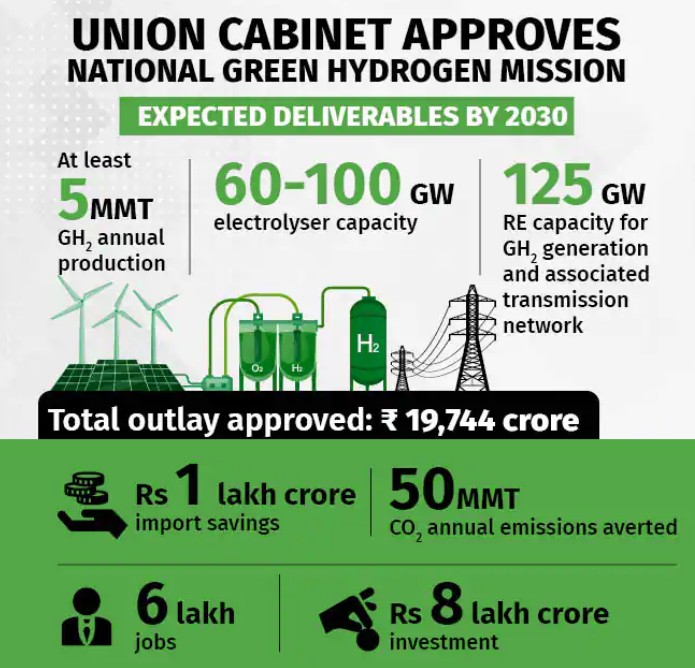
Objectives of the National Green Hydrogen Mission
- Develop green hydrogen production capacity of at least 5 MMT (Million Metric Tonne) per annum by 2030.
- Add renewable energy capacity of about 125 GW (gigawatt) in India by 2030.
- Generate over Rs 8 lakh crore of investments and create six lakh jobs.
- Reduce fossil fuel imports by over Rs 1 lakh crore and abate nearly 50 MT of annual greenhouse gas emissions.
Significance of the National Green Hydrogen Mission
- Decarbonization of industrial, mobility, and energy sectors.
- Reduced dependence on imported fossil fuels and feedstock.
- Development of indigenous manufacturing capabilities.
- Creation of employment opportunities.
- Advancement of efficient fuel cell technologies.
Potential of the National Green Hydrogen Mission in India
- India's favorable geographic location and abundance of sunlight and wind make it suitable for green hydrogen production.
- Green hydrogen technologies are promoted in sectors where direct electrification is not feasible, such as heavy-duty, long-range transport, certain industrial sectors, and long-term storage in the power sector.
- The nascent stage of the industry allows for the creation of regional hubs that export high-value green products and engineering services.
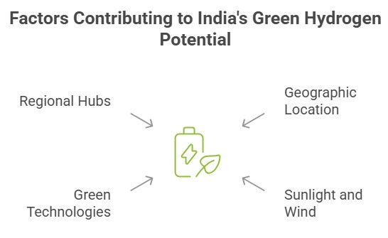
Challenges Before the National Green Hydrogen Mission
- Economic Nascent stage of global green hydrogen development.
- Lack of necessary infrastructure for executing intermediary steps.
- sustainability of extracting green hydrogen for commercial use, particularly for transportation fuel cells.
What is Green Hydrogen?
- Hydrogen is an important industrial fuel used in various applications, but most hydrogen is currently produced from coal (black or brown hydrogen).
- Green hydrogen is produced by passing electric current through water via electrolysis using renewable sources like wind or solar energy.
- Colors attached to hydrogen indicate the source of electricity used, with green hydrogen derived from renewable sources.

Current Production and Need for Green Hydrogen
- Green hydrogen currently accounts for less than 1% of global hydrogen production due to its high production cost compared to other types.
- Green hydrogen is one of the cleanest energy sources, with almost zero emissions, and can be used in fuel cells for cars and energy-intensive industries.
- Countries worldwide are focusing on developing green hydrogen capacity to enhance energy security and reduce carbon emissions.
Way Forward
- Incentives should be announced to encourage industrial hydrogen users to adopt green hydrogen.
- Development of supply chains including pipelines, tankers, storage facilities, and distribution networks.
- Implementation of a skill development program to train workers for the green hydrogen economy.
- Leveraging low-cost renewable generating plants and experience from solar and wind auctions to reduce the cost of green hydrogen.
- Exploiting the market potential and the young demography of India to drive the application of hydrogen-based technologies.
Conclusion
National Green Hydrogen Mission holds immense potential for India to become a net exporter of green hydrogen. By developing a robust production capacity and renewable energy infrastructure, India can achieve significant reductions in fossil fuel imports, greenhouse gas emissions, and create job opportunities. Despite challenges in the nascent global market and economic sustainability, the adoption of green hydrogen is crucial for decarburization and energy security. With strategic interventions, investments, and supportive policies, India can pave the way towards a sustainable and clean energy future.
26. India’s Natural Gas Policy, CGD Projects, Infrastructure Development, Petroleum Ministry
The Ministry of Petroleum & Natural Gas in India has taken a significant step to enhance gas infrastructure activities in the country. They have introduced the National Dossiers and Draft City Gas Distribution (CGD) Policy for states. Under the Petroleum and Natural Gas Regulatory Board (PNGRB), the Prime Minister has initiated the ninth bidding for city gas distribution (CGD) projects.
Natural Gas in India: Definition, Conversion and By-products
- Definition: Natural gas is primarily composed of methane and is a fossil fuel source. It is commonly found alongside other fossil fuels such as coal beds and is naturally produced by methanogenic organisms in environments like bogs, landfills, and marshes.
- Conversion and By-products: Natural gas undergoes processing to become a cleaner fuel for consumption. During the processing, several by-products like propane, ethane, butane, carbon dioxide, and nitrogen are extracted, which have further applications.
- India's Energy Mix and Goals: India is the world's third-largest energy consumer, with coal and oil dominating its energy mix. Natural gas accounted for only 6.2% of India's total primary energy supply in 2016.
- The government aims to increase the share of gas in the primary energy mix to 15% by 2022.
- Gas Consumption and Sectors in India.

Advantages of Natural Gas
- Energy Efficiency: Natural gas has a higher energy output compared to other fossil fuels.
- Reduced Health Risks: Natural gas is a cleaner and safer fuel compared to coal and liquid fuels, contributing to improved air quality.
- Economic Cost Optimization: Natural gas (CNG) is more cost-effective than petrol and diesel, saving space without the need for cylinder storage.
- Meeting Global Commitments: India committed to reducing carbon emissions by 33%-35% of 2005 levels by 2030 under the COP21 Paris Convention.
- Climate Sustainability: Natural gas can significantly reduce carbon emissions in various sectors like domestic kitchens, transportation, and industries.
- Relatively Convenient: Natural gas is supplied through pipelines, eliminating the need for cylinder storage and saving space.
- Wide-Ranging Applications: Natural gas can be used for power generation, city gas distribution, transportation, fertilizer production, and petrochemical industries.
Gas Supply in India
- Domestic Gas Sources: Gas is sourced from oil & gas fields in western and southeastern regions and the North East Region (Assam & Tripura).
- Import of Liquefied Natural Gas (LNG): LNG is imported through terminals in Gujarat, Maharashtra, and Kerala, with two more under construction in Tamil Nadu and Odisha.
Major Natural Gas Pipeline Projects
- Jagdishpur – Haldia/Bokaro – Dhamra Pipeline Project (JHBDPL) & Barauni- Guwahati Pipeline project (BGPL): Supports the revival of fertilizer plants and ensures gas supply to various regions.
- North East Region (NER) Gas Grid: A joint venture to develop trunk pipeline connectivity in North Eastern States.
- Kochi-Koottanad- Bangalore-Mangalore (Ph-II) Pipeline Project (KKBMPL): Connects the new Ennore LNG Terminal with demand centers in the region.
- Ennore-Thiruvallur-Bangalore-Nagapattinum– Madurai – Tuticorin Natural gas pipeline (ETBNMTPL): Links Ennore LNG Terminal with demand centers.
Government Initiatives for Natural Gas
- Draft CGD Policy: Released by the Ministry of Petroleum and Natural Gas to facilitate the implementation of CGD networks and value-added services in states.
- CNG/LNG as Preferred Fuel in Public Transportation: Encouraging state transport corporations to prioritize CNG/LNG buses to promote cleaner fuel usage.
- $60bn Investment Plan: Significant investment in gas pipeline and terminal infrastructure.
- National Gas Grid: Aims to remove regional imbalance, connect gas sources to demand centers, and develop CGD networks.
- Urja Ganga Project: Gas pipeline project by GAIL to transport gas to various regions.
- Initiatives for Energy Security: Bio-CNG policy, SATAT initiative, and policy guidelines for exploration and exploitation of unconventional hydrocarbons.
- Regulatory Framework Enhancement: PNGRB's role in granting authorization for CGD networks to expand coverage and ensure availability of CNG/PNG.
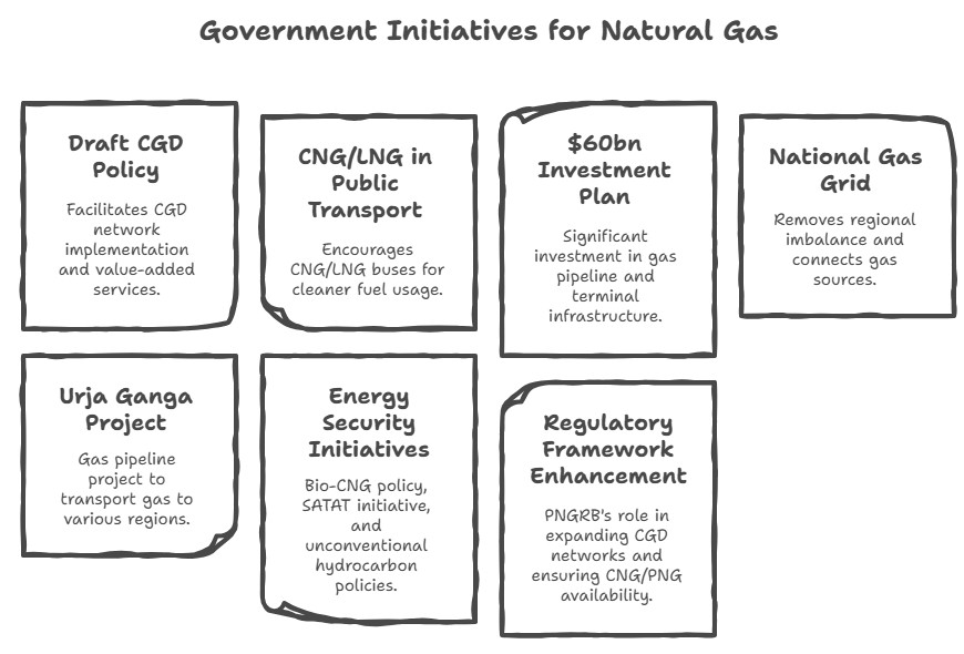
Challenges in the Natural Gas Sector
- Energy Trilemma and Declining Index Ranking: India's energy trilemma index ranking has declined consistently since 2000, mainly due to reduced energy storage, limited diversity in primary energy supply, and increased import dependency.
- Global Oil Market Vulnerability: The global oil market remains vulnerable to various risks, including natural disasters, technical accidents, and geopolitical tensions, impacting India's energy security.
- Low Investments in Gas Infrastructure: The private sector has shown limited interest in investing in gas pipelines in India due to uncertainty over availability and the domestic market's capacity to absorb expensive imported gas.
- Cooperative Federalism Challenges: Pipeline laying has faced obstacles due to land acquisition issues and unviable routes proposed by state governments, leading to major project delays.
- High Import Dependency: Insufficient domestic gas production, particularly from KG gas-fields, has made India heavily reliant on gas imports, especially from Qatar.
- Underutilization of Gas-Based Power Capacity: More than half of the natural gas-based power capacity remains idle due to a lack of domestic gas supply, hindering the transformation of India's economy to a gas-based one.
- Environmental Concerns: Offshore drilling operations pose environmental risks, including harm to marine life, contamination of water, and the potential for oil spills.
Way Forward
- Diversify Import Sources: India should explore emerging gas production centers in Africa, the Middle East, Southeast Asia, and the Gulf to diversify its gas imports and ensure a robust and secure natural gas strategy.
- Integrated Energy Policy Implementation: Consolidate various ministries into a single Ministry of Energy and Environment to enhance energy independence, increase access to affordable energy, promote sustainability, and drive economic growth.
- Promote Domestic Gas Production: Utilize advanced drilling techniques and establish large-scale import partnerships to develop indigenous gas resources and reduce reliance on imports.
- Viability Gap Funding: Encourage projects through viability gap funding to attract private sector participation, address shortcomings, and improve project efficiencies.
- Pricing Reforms: Bring natural gas under the Goods and Services Tax (GST) regime, treat it at par with coal, and consider customs duty waivers on liquefied natural gas (LNG) to boost its affordability and usage.
- Sector-Specific EIA Manual: Develop a specialized Environmental Impact Assessment (EIA) manual for exploring and producing unconventional hydrocarbon resources to effectively address environmental concerns.
- Enhance Infrastructure and Security Measures: Invest in the development of adequate gas infrastructure, improve security measures in the oil and gas sector, and strengthen international partnerships to ensure a stable and secure energy supply.
Conclusion
India's hydrocarbon policy and initiatives reflect its commitment to a cleaner and more sustainable energy future. By addressing challenges and implementing strategic measures, India can accelerate its transition towards a gas-based economy while ensuring energy security and environmental sustainability.
27. Lithium Reserves
The Geological Survey of India (GSI) has achieved a significant milestone by establishing the first-ever 'inferred' Lithium resources (G3) of 5.9 million tonnes in the Salal-Haimana area of the Union Territory of Jammu & Kashmir.
Understanding Inferred Resources
- Inferred mineral resources are characterized by a low level of confidence in their estimated quantity, grade, and mineral content.
- These resources are based on data collected from sources such as outcrops, trenches, pits, workings, and drill holes, which may have limited or uncertain quality and lower reliability from geological evidence.
- The classification of inferred resources is defined by the United Nations International Framework Classification for Reserves/Resources - Solid Fuels and Mineral Commodities of 1997 (UNFC-1997).
Introducing UNFC-1997
- UNFC-1997 is a standardized system developed by the UN Economic Commission for Europe for the classification and reporting of reserves and resources of solid fuels and mineral commodities.
- It ensures transparency, consistency, and comparability in reporting geological, engineering, and economic information related to reserves and resources.
- Governments, industry, and financial institutions worldwide widely use UNFC-1997 for comparing data on reserves and resources between different countries and regions.
Understanding Lithium
- Overview: Lithium (Li), often referred to as 'White gold,' is a soft and silvery-white metal highly demanded for rechargeable batteries.
- Extraction: Lithium can be extracted through solar evaporation of large brine pools or hard-rock extraction of the ore, depending on the deposit type.
- Uses: Lithium is a crucial component in electrochemical cells used in electric vehicles (EVs), laptops, mobiles, and other devices. It is also used in thermonuclear reactions and in the production of alloys for lightweight materials.
Global and Indian Lithium Reserves
- Major Global Lithium Reserves: Chile, Australia, and Argentina are the top countries with significant lithium reserves. The region known as the Lithium Triangle includes Chile, Argentina, and Bolivia.
- Lithium Reserves in India: A preliminary survey in Southern Karnataka's Mandya district estimated lithium reserves of 14,100 tonnes. Other potential sites for lithium reserves in India include mica belts in Rajasthan, Bihar, Andhra Pradesh, pegmatite belts in Odisha and Chhattisgarh, and Rann of Kutch in Gujarat.
Current Lithium Demand and Imports in India
- India currently relies on imports for lithium cells and batteries, with over 165 crore lithium batteries estimated to have been imported between FY17 and FY20, costing more than $3.3 billion.
- The country's efforts to secure lithium sourcing agreements aim to reduce dependence on imports from China, the primary source of both raw materials and cells.
- As India enters the EV market, it aims to overcome the late entry by securing domestic lithium sources.
Significance of the Lithium Discovery
- Assisting Target Achievements: India's commitment to achieving net-zero emissions by 2070 necessitates the availability of lithium for electric vehicle (EV) batteries.
- The country's Central Electricity Authority estimates a requirement of 27 GW of grid-scale battery energy storage systems by 2030, requiring substantial amounts of lithium.
- Addressing Global Shortages: The World Economic Forum has warned of global lithium shortages due to the increasing demand for EVs and rechargeable batteries, estimated to reach 2 billion by 2050.
- Concentration of lithium resources in a few locations, with 54% found in Argentina, Bolivia, and Chile, puts the world's supply under strain. IEA predicts potential lithium shortages by 2025.
Applications of Lithium
- Lithium-ion batteries: Lithium's most well-known application is in rechargeable and lightweight lithium-ion batteries that power electronic devices, ranging from cell phones to laptops.
- These batteries enable the storage of renewable energy from sources like solar and wind, power electric vehicles, and promote development through access to energy.
- Other Uses: Lithium finds applications in pharmaceuticals, glass and ceramics production, aerospace and military industries for temperature control, and high-temperature lubricating greases.
Challenges Associated with Lithium Extraction
- Further Exploration: The GSI needs to conduct additional exploration to ascertain if the estimated lithium resources in Jammu and Kashmir are mineable reserves.
- Accessibility and Purity: Detailed information regarding the accessibility and purity of inferred resources holds significant importance.
- Technological Limitations: India currently lacks lithium extraction technologies, which need to be developed to exploit the discovered resources.
- Geostrategic Concerns: Jammu and Kashmir's historical cross-border tensions, domestic insurgency, and terrorism pose challenges to resource extraction in the region.
- Environmental Impact: Extracting lithium from hard rock mines involves processes like open-pit mining and roasting the ore using fossil fuels, leading to significant water consumption, CO2 emissions, depletion of waterways and groundwater, biodiversity loss, and air pollution.
- Additionally, the unstable nature of the Himalayas raises concerns about land sinking incidents.
Conclusion
The discovery of lithium reserves in India holds significant strategic importance as it reduces import dependence and promotes self-reliance in the transition to green energy. By proactively addressing the challenges and scaling up domestic lithium production, India can avoid repeating its history of fossil fuel imports and emerge as a key player in the electric vehicle supply chain.
28. Rare Earth Metals
Introduction
- Rare earth elements or metals comprise a group of 17 chemical elements in the periodic table. These elements include the 15 lanthanides, along with scandium and yttrium, which are often found in the same ore deposits as the lanthanides and share similar chemical properties. Despite their classification, most of these elements are not actually rare. One of the rare earths, promethium, is radioactive.
Key Points:
- They are integral to a range of technologies including electronics, healthcare, and defense.
- The demand for these metals is growing due to a global focus on green energy.
- India has the third-largest reserves of rare earth minerals globally.
- China holds a significant monopoly over the global rare earths market.
- Indian industries have proposed a mission to diversify sources of strategic raw materials.
- Despite its reserves, India only contributes 1% to global rare earth output.
- China used to produce 90% of the world's rare earth but now produces 60%.
- Exploration in India is conducted by the Bureau of Mines and the Department of Atomic Energy.
Way Forward
- India should learn from advanced economies' strategies to secure their mineral needs and consider participating in multinational fora focused on critical mineral supply chains.
- Existing partnerships such as the Quad and BIMSTEC could be utilized to foster dialogues on rare earths.
- Top-level decision-making within the government is necessary to strategize the creation of vertically integrated supply chains for green technology manufacturing.
- Establishing a new Department for Rare Earths (DRE) can play a vital role as a regulator and enabler for businesses in the rare earths sector.
Conclusion
India must take proactive steps to reduce its dependence on rare earth metal imports, particularly from China. This includes establishing a dedicated Department for Rare Earth, promoting private-sector mining, and fostering partnerships with other countries. By leveraging its rare earth resources and developing robust supply chains, India can boost domestic production, support its climate change goals, and enhance national security in the long term.
29. India Strategic Oil Reserve
Global strategic petroleum reserve: Understanding the Impact
- The Impact of Global Oil Markets: The interconnectedness of the world's oil markets means that disturbances in one region can have a far-reaching impact on prices worldwide.
- Managing Supply Disruptions: Countries with reserves can release a portion of their supplies during significant disruptions caused by politics or natural calamities, helping to stabilize prices.
- Import-Export Balance: Nations are required to maintain reserves equal to their average annual imports of crude oil for 90 days, as per an agreement among IEA members.
Strategic Oil Reserves of India: Ensuring Energy Security
- Developing Emergency Stocks: India aims to establish emergency stocks similar to the reserves established by the US and its Western allies after the 1970s oil crisis.
- Exploring Salt Cavern-Based Reserves: Engineers India (EIL), a government-owned engineering consultancy firm, is researching the feasibility of creating salt cavern-based strategic oil reserves in Rajasthan.
- Planned Storage Facility: If realized, India's first oil storage facility built inside a salt cavern would add to the existing strategic oil storage facilities in Andhra Pradesh, Mangaluru, and Padur.
- Enhancing Energy Security: As India heavily relies on oil imports, strategic petroleum reserves (SPR) play a crucial role in ensuring energy security during emergencies or disruptions in the global supply chain.
India's Current Strategic Oil Reserves: Capacities and Expansion
- Current SPR Capacity: India's current SPR capacity is 5.33 million tonnes, equivalent to about 39 million barrels of crude, providing the country's oil needs for 9.5 days.
- Expanding Capacity: India is expanding its SPR capacity by 6.5 million tonnes at Chandikhol in Odisha and Padur.
- Management and Consultation: Indian Strategic Petroleum Reserve, a special purpose company under the Petroleum Ministry, manages India's strategic oil reserves, with EIL serving as the project management consultant.
- Salt Cavern-Based Storage: Salt cavern-based storage, considered cost-effective and less labor-intensive than rock caverns, could significantly contribute to India's SPR.
- Existing Rock Cavern Deposits: India currently has three strategically important oil deposits located in the rock caves of Mangaluru, Padur, and Visakhapatnam.
- Rajasthan's Advantage: Rajasthan is chosen as the ideal location for the salt-based cavern petroleum oil reserve project due to its geological and infrastructure advantages.
Rock vs. Salt Cavern Reserves
- Salt caverns, created through solution mining, offer easier, quicker, and less expensive oil storage compared to excavated rock caverns.
- These caverns provide natural impermeable barriers against hydrocarbons and are well-sealed, enabling efficient injection and extraction of oil.
- The US Strategic Petroleum Reserve relies entirely on salt caverns, which are also suitable for storing other resources like natural gas and hydrogen.
Potential for Crude Oil and Petroleum Storage in India
- Rajasthan, with abundant salt deposits, emerges as the most suitable region for constructing strategic salt cavern storage facilities.
- Existing infrastructure in Rajasthan, including a refinery in Barmer and crude pipelines, supports the creation of strategic oil reserves.
- Collaboration between Engineers India (EIL) and Germany's DEEP.KBB GmbH aims to bridge the technical expertise gap for salt cavern-based storage.
Programme for Strategic Petroleum Reserves: The Journey So Far
- Emulating Western Allies: India's strategic oil reserves are part of the endeavor to establish emergency stocks similar to the US and Western allies' reserves after the 1970s oil crisis.
- Authorization for Release: The government has the authority to release crude oil from reserves in the event of supply disruptions caused by natural disasters or abnormal price increases due to unforeseen global events.
Conclusion: Strengthening Energy Infrastructure
- Existing Storage Capacity: India's oil marketing companies have storage facilities for crude oil and petroleum products equivalent to 64.5 days of demand, in addition to the SPR's capacity to meet 9.5 days of oil requirement.
- ADNOC's Contribution: The Abu Dhabi National Oil Company (ADNOC) has stocked around 0.8 million tonnes of crude oil in the Mangaluru strategic reserve as part of India's decision to commercialize its reserves.
- Public-Private Partnerships: In the second phase of the strategy, the government plans to establish strategic reserves through public-private partnerships to maximize commercial potential and reduce costs.
30. Atomic Minerals in India: Uranium and Thorium Reserves & Distribution
Atomic Minerals in India: India possesses abundant reserves of atomic minerals, including uranium and thorium, which are vital for nuclear energy production. Additional atomic minerals such as beryllium, lithium, and zirconium also contribute to India's mineral wealth.
Atomic Minerals in India Uranium Resources
- Uranium deposits in India are primarily found in crystalline rocks.
- Jharkhand state holds 70% of the country's uranium reserves.
- Major uranium deposits occur in the Singhbhum and Hazaribagh districts of Jharkhand, Gaya district of Bihar, and Saharanpur district of Uttar Pradesh.
- The estimated total reserves of uranium in India amount to 30,480 tonnes.
- India currently produces about 2% of the world's uranium.
Mines of Atomic Minerals in India
- Uranium Mines: Jaduguda, Bhatin, Narwapahar, Bagjata, Turamdih, Banduhurang, Mohuldih
- Other Minerals with Atomic Content:
- Monazite: Concentrated on the Kerala coast, containing an estimated 15,200 tonnes of uranium.
- Ilmenite: Found in Jharkhand state.
- Beryllium: Reserves present in Rajasthan, Jharkhand, Andhra Pradesh, and Tamil Nadu.
- Zirconium: Discovered along the Kerala coast and in alluvial rocks of Ranchi and Hazaribagh districts.
- Lithium: Widely distributed in the mica belts of Jharkhand, Madhya Pradesh, Rajasthan, and Bastar region of Chhattisgarh.
Atomic Minerals in India Thorium Reserves
- India possesses the largest thorium deposits globally.
- Thorium is derived from minerals like monazite (containing 10% thoria and 0.3% urania) and thorianite.
- India aims to advance to the third stage of nuclear fuel consumption, relying on thorium to achieve self-reliance in nuclear fuel supply.

Global Uranium Distribution
- Primary uranium deposits are abundant in Australia, Kazakhstan, and Canada.
- Significant mines include Olympic Dam and Ranger mine in Australia, and the Athabasca Basin region in Canada.
- Kazakhstan leads global uranium production with 42% of the world's supply, followed by Canada (13%) and Australia (12%).
Uranium Situation in India
- Jharkhand: Jaduguda, Bhatin, Narwapahar, Bagjata, Turamdih, Banduhurang, Mohuldih
- Meghalaya: Kylleng, Pyndeng-Shahiong (Domiasiat), Mawthabah, Wakhym
- Lambapur-Peddagattu, Tummalapalle
Thorium: A Promising Element
- Thorium, symbolized as Th with atomic number 90, occurs naturally in significant quantities. Thorium is estimated to be three to four times more abundant than uranium in the Earth's crust.
- Monazite sands, found widely on the Kerala coast, serve as the primary source of refined thorium. Thorium has the potential to replace uranium as nuclear fuel, although few thorium reactors have been completed to date.
Monazite and Rare Earth Metals
- Monazite is a reddish-brown phosphate mineral containing rare earth metals. Rare earth elements are crucial for various modern technologies, including electronics, communication, clean energy, and defense.
- There are 17 rare earth elements, including the fifteen lanthanides and scandium and yttrium.
Conclusion
India possesses substantial reserves of uranium and thorium, with efforts underway to achieve self-reliance in nuclear fuel supply. The country's abundant atomic mineral resources contribute to its ambitious plans for expanding nuclear energy production.
31. USA-led Minerals Security Partnership (MSP)
The Indian Government is increasingly concerned about India's absence from the Minerals Security Partnership. A US-led partnership aimed at securing supply chains of critical minerals and reducing dependence on China.
Rising Demand for Critical Minerals
- Projected significant expansion in demand for critical minerals, which are essential for clean energy and other technologies in the coming decades.
- These minerals are used in the production of mobile phones, computers, batteries, electric vehicles, solar panels, wind turbines, aerospace, communications, and defense industries.
Definition and Significance of Critical Minerals
- Critical minerals are elements used in essential modern-day technologies and are susceptible to supply chain disruptions.
- Graphite, Lithium, and Cobalt are major critical minerals used in EV batteries. Rare earth minerals are vital for semiconductors and high-end electronics manufacturing.
- These resources are key to the transition towards clean energy and digital economy worldwide. Supply shocks can severely impact economies and strategic autonomy of countries dependent on others for critical minerals.
Minerals Security Partnership (MSP)
- Objective: To strengthen critical mineral supply chains.
- Partners: United States, Australia, Canada, Finland, France, Germany, Japan, Republic of Korea, Sweden, United Kingdom, European Commission.
- Focus: Cobalt, Nickel, Lithium, and 17 "rare earth" minerals.
- Significance: Catalyzes investment from governments and the private sector, adhering to high environmental, social, and governance standards.
Concerns for India's Exclusion from MSP
- Supply of Critical Minerals: India's growth strategy relies on a shift to electric vehicles and increased electronics manufacturing, necessitating secure mineral supplies.
- India lacks extractable quantities of certain rare earth elements like Dysprosium, Terbium, and Europium.
- Dependency on Other Countries: India would need support for the supply of critical minerals it lacks. Other countries in the partnership have reserves and technology for extraction and processing.
- Technology Status: India's limited expertise in critical mineral extraction and processing likely contributed to its exclusion from the partnership. Countries like Australia, Canada, and Japan possess the necessary reserves and technology.
India's Efforts to Address Critical Minerals
- Lithium Agreement: India signed an agreement with an Argentinian firm in 2020 to jointly prospect lithium reserves in Argentina.
- India-Australia Critical Minerals Investment Partnership: India and Australia aim to strengthen their partnership in critical minerals projects and supply chains.
- Australia's resources can assist India in meeting its emission reduction goals and fulfilling demands for critical minerals.
Concerns for India
- Dependency Issue
- Without exploring and producing critical minerals domestically, India may rely heavily on a few countries, including China, for its energy transition plans.
- This would create a similar dependency to that of oil.
- Lack of Expertise
- India's exclusion from the MSP is attributed to its limited expertise compared to other partner countries.
- Australia, Canada, and Japan possess reserves and advanced technology for extraction and processing.
Way Ahead
- India should promote competition and innovation in the rare earth sector, attracting significant capital investment and establishing competitive facilities.
- Consider creating a new Department for Rare Earths (DRE) under the Ministry of Petroleum & Natural Gas, utilizing exploration, exploitation, refining, and regulation capabilities.
- Encourage Indian private players to engage in junior exploration businesses in the Indian Ocean Region (IOR) to prospect for rare earth elements and supply value-added products domestically.
Conclusion
India's exclusion from the Minerals Security Partnership (MSP) highlights the need for action. To secure a stable supply of critical minerals, India must open its rare earth sector to competition, establish a dedicated Department for Rare Earths (DRE), and encourage private exploration in the Indian Ocean Region. These steps will help India become self-reliant and meet the demands of its growing energy and technology sectors.
32. Role and Importance of Industrial Corridors in India’s Economic Development
Industrial corridors play a vital role in India's economic development by promoting industrialization, attracting investments, and creating employment opportunities. These strategically planned stretches of land are designed to support industrial activities and associated infrastructure. Industrial corridors aim to leverage locational advantages and foster regional connectivity.
Need for Industrial Corridors in India
- The different sectors of an economy are inter-dependent on each other.
- Industrial corridors, recognizing this inter-dependence, offer effective integration between industry and infrastructure, leading to overall economic and social development.
- According to the World Economic Forum, about 35% of the projected growth in the world’s urban population until 2050 will come from India, China, and Nigeria, combined.
- A study titled ‘India’s Urban System: Sustainability and Imbalanced Growth of Cities’, points to the fact that million-plus cities in India increased in number from 5 (with a share of the total urban population of 18.81%) in 1951 to 23 (32.54% of the urban population) in 1991, and to 53 (42.62% of the urban population) in 2011, whereas the share of small and medium cities in total urban population registered a consistent decline over the years.
|
Industrial Corridors and Infrastructure Development
|
Industrial Corridors in India
|
PM GatiShakti Plan
- National Industrial Corridor projects are getting developed on the overall framework of PM GatiShakti - National Master Plan to provide a systematic, multi modal connectivity to various economic zones for a seamless movement of people, goods and services resulting in efficient conduct of logistics and economic activities.
- The development of major industrial corridor projects will be implemented through the National Industrial Corridor Development and Implementation Trust (NICDIT).

National Industrial Corridor Development Programme in India
|
Advantages for Developing Industrial Corridors in India
- Enhanced Connectivity: Industrial corridors provide a well-planned and integrated transportation network, including highways, railways, ports, and airports, facilitating seamless movement of goods and people.
- Boost to Manufacturing and Economic Growth: Industrial corridors attract investment, promote industrialization, and boost economic growth by providing a conducive environment for industries and manufacturing clusters.
- Employment Generation: The development of industrial corridors creates numerous job opportunities, particularly in the manufacturing sector, contributing to employment generation and addressing regional disparities.
- Infrastructure Development: Industrial corridors lead to the development of world-class infrastructure, including industrial parks, logistic hubs, and smart cities, which further attract investments and improve the overall business environment.
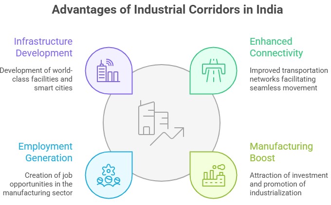
Challenges in Developing Industrial Corridors in India
- Land Acquisition and Rehabilitation: One of the major challenges is acquiring large tracts of land for corridor development, which can face resistance from local communities. Proper rehabilitation and compensation for displaced populations need to be addressed.
- Environmental Concerns: Industrial corridors can have adverse environmental impacts, including deforestation, air and water pollution, and habitat destruction. Ensuring sustainable development practices and mitigating environmental risks is crucial.
- Infrastructure Financing: Developing industrial corridors requires significant investment in infrastructure. Securing adequate financing from both public and private sources can be challenging, especially for long-term projects.
- Coordination and Stakeholder Management: Coordinating multiple agencies, including central and state governments, private investors, and local communities, is essential for successful corridor development. Effective stakeholder management and resolving conflicts of interest are crucial for smooth implementation.
Way Forward
- Comprehensive Planning: Conduct thorough feasibility studies, spatial planning, and environmental impact assessments to ensure sustainable and well-integrated development of industrial corridors.
- Public-Private Partnership: Foster strong collaborations between the government and private sector entities to attract investments, share risks, and leverage expertise for efficient implementation and operation of industrial corridors.
- Infrastructure Development: Continuously upgrade and expand transportation networks, including roads, railways, ports, and airports, to improve connectivity and facilitate seamless movement of goods and people.
- Regulatory Reforms: Streamline regulatory processes and ensure ease of doing business within the industrial corridors. Implement transparent and investor-friendly policies to attract both domestic and foreign investments.
33. Global and Indian Industrial Regions: Factors, Major Hubs & IT Sector Growth
Industrial regions play a crucial role in shaping the economic landscape of the world. These regions are characterized by concentrations of industries and manufacturing activities, typically driven by factors such as access to resources, favorable geographical conditions, skilled labor pools, infrastructure, and market proximity. Industrial regions are dynamic hubs of economic activity, fostering innovation, productivity, and regional development.
Factors Affecting Location of Industries

Industrial Regions of the World
- Industrial regions emerge when a number of industries locate close to each other and share the benefits of their closeness.
- Factors Influencing Industrial Region Location:
- Proximity to Sea Ports
- Availability of Coal Fields
- Temperate Climate Zones
Major Industrial Regions Worldwide
- Eastern North America
- Western and Central Europe
- Eastern Europe
- Eastern Asia
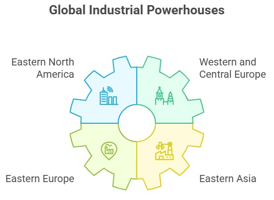
Industrial Regions in India
- Mumbai-Pune Cluster
- Bangalore-Tamil Nadu Region
- Hugli Region
- Ahmedabad-Baroda Region
- Chottanagpur Industrial Belt
- Vishakhapatnam-Guntur Belt
- Gurgaon-Delhi-Meerut Region
- Kollam-Thiruvanathapuram Industrial Cluster

Distribution Of Major Industries
- The world’s major industries are the iron and steel industry, the textile industry and the information technology industry.
- The iron and steel and textile industry are the older industries while information technology is an emerging industry.
- The countries in which iron and steel industry is located are Germany, USA, China, Japan and Russia.
- Textile industry is concentrated in India, Hong Kong, South Korea, Japan and Taiwan.
- The major hubs of Information technology industry are the Silicon valley of Central California and the Bangalore region of India.
Importance of IT Sector for Industrial Regions in India
|
FY 2019-20 |
$ 150 Billion |
|
FY 2020-21 |
$ 151 Billion |
|
FY 2021-22 |
$ 178 Billion |
- As per the data provided by National Association of Software and Service Companies (NASSCOM), the total amount of IT export from the country during last three years is as below:
- As per National Association of Software and Services Companies (NASSCOM), Indian Information Technology (IT) Industry directly employs around 51 lakh persons in FY 2021-22, most of which are IT skilled.
- In addition, with increasing digitalization under the Digital India program in the last 7 years, other economic sectors have created large opportunities for digitally enabled jobs.
- As per report by Ministry of Electronics & IT on “India’s trillion-dollar digital opportunity”, India is poised to be a trillion dollar digital economy and could support 60 to 65 million digitally enabled jobs by 2025-26.
- As per NASSCOM, the projected requirement of manpower by Indian IT industry itself by the year 2026 would be around 95 lakhs, for India to maintain the growth momentum in IT sector and also of which 55 lakh will be digitally skilled across key digital technologies such as cloud computing, AI, big data analytics and IoT etc.
Government Initiatives to Boost IT Exports in Industrial Regions
- Software Technology Parks of India (STP) Scheme:
- STPI implements the 100% export-oriented STP Scheme for software development and export.
- Registered IT/ITeS units under STPI have shown consistent YoY growth, reaching $80.3 billion in FY 2021-22.
- Special Economic Zones (SEZs):
- SEZ Act, 2005, supports the promotion of goods and services export, job creation, and economic activities.
- SEZs facilitate a favorable environment for IT companies, attracting investments and boosting exports.
- Future Skills PRIME Program:
- MeitY collaborates with IT/ITeS Sector Skills Council-NASSCOM for reskilling/upskilling of IT professionals.
- The program focuses on emerging technologies such as AI, Big Data Analytics, Cloud Computing, and Cybersecurity.
- Domain-Specific Centers of Entrepreneurship:
- Government establishes centers across India to nurture innovation, startups, and private investments.
- These centers cater to new and emerging technologies, fostering a robust ecosystem for growth and employment.
- National Policy on Software Products-2019:
- The policy aims to position India as a global software product hub through innovation and IP protection.
- It encourages technology startups, specialized skill development, and the overall development of the software product sector.
- Next Generation Incubation Scheme (NGIS):
- NGIS supports the software product ecosystem and aligns with the National Policy on Software Products.
- Its objective is to enhance competitiveness, create employment opportunities, and foster continued growth.
- Market Outreach Initiatives and Market Development:
- Initiatives provide support to Indian IT/ITeS SMEs in generating market linkages in the USA, UK, Nordics, and Africa.
- These efforts aim to enhance export opportunities and expand overseas market presence for the IT sector.
Challenges for IT Sector in India
- Skill Gap: There is a shortage of skilled professionals with specialized IT skills, leading to a skill gap in the industry.
- Infrastructure Limitations: Inadequate and unreliable IT infrastructure, including power supply and internet connectivity, pose challenges for the smooth functioning of the IT sector.
- Data Security and Privacy Concerns: The increasing prevalence of cyber threats and data breaches raises concerns about data security and privacy, impacting the trust of clients and customers.
- Global Competition: The IT sector faces intense competition from other countries with lower labor costs and advanced technological capabilities, making it challenging to retain and attract clients.
- Regulatory Environment: Complex and evolving regulations related to data protection, intellectual property rights, and taxation can create compliance challenges for IT companies.
- Talent Retention and Attrition: High attrition rates and the challenge of retaining skilled employees pose significant challenges in maintaining stability and continuity in projects.
- Changing Technology Landscape: Rapid advancements in technology require continuous upskilling and adaptation, which can be a challenge for both individuals and organizations.
- Digital Divide: Disparities in access to technology and digital literacy create a digital divide, limiting the sector's growth potential in certain regions or sections of society.
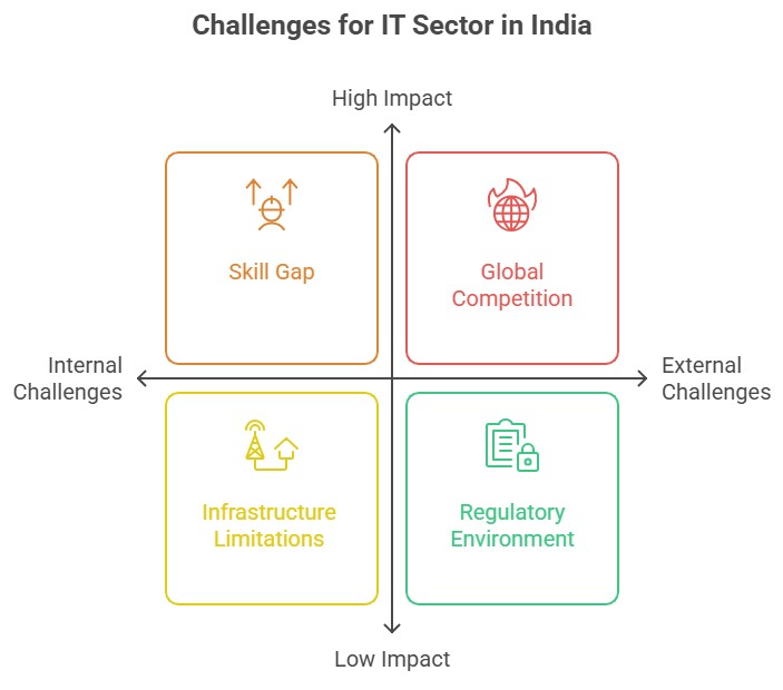
Way Forward For Industrial Regions of the World
- Foster Innovation and Research: Promote investment in research and development to drive innovation and technological advancements in industrial regions.
- Enhance Infrastructure: Improve transportation networks, logistics systems, and connectivity to facilitate the efficient movement of goods and services within and outside industrial regions.
- Sustainable Development: Encourage sustainable practices and technologies to minimize environmental impacts and promote eco-friendly industrialization.
- Collaboration and Networking: Foster collaboration between industries, academia, and government bodies to facilitate knowledge sharing, skill development, and industry-academia partnerships.
Way Forward For Industrial Regions in India
- Skill Development: Focus on skill development initiatives to create a skilled workforce capable of meeting the evolving needs of industries in areas like emerging technologies, digitalization, and automation.
- Ease of Doing Business: Simplify bureaucratic processes, reduce regulatory burdens, and provide a conducive business environment to attract investments and promote entrepreneurship.
- Infrastructure Development: Invest in robust infrastructure, including transportation, power, and digital connectivity, to support industrial growth and enhance the competitiveness of Indian industrial regions.
- Regional Imbalance: Address regional imbalances by promoting industrialization in underdeveloped regions, ensuring inclusive growth, and reducing inter-regional disparities.
- Sustainable Industrialization: Promote sustainable practices, renewable energy adoption, waste management, and environmental regulations to ensure sustainable industrial growth.
- International Cooperation: Strengthen international collaborations and partnerships to attract foreign investments, facilitate technology transfer, and promote export-oriented industries.
- Policy Support: Continuously review and refine industrial policies, addressing challenges, and aligning with global trends to create a favorable business environment for industrial development.
34. Mangroves in India: Importance, Threats & Conservation Initiatives
Mangroves are tropical plants that can withstand tidal inundation, salt water, and loose, damp soil. Climate, salt water, tidal fluctuation, and soil type all seem to have a significant role in the dispersal of mangroves. There are more than 50 different species throughout the globe.
- Ecological adaptations: Mangroves have evolved to withstand harsh estuarine environments. Their capacity to endure brackish waters and flooded, anoxic (lack of oxygen) soil are two of their main adaptations.
Mangroves in India: Distribution and Growth
- India covers 3% of South Asia's mangroves, accounting for 6.8% of the world's total. The country's mangrove cover has increased by 54 sq km, reaching 4,975 sq km or 0.15% of its total area.
- The Sundarbans in West Bengal make up over half of India's mangrove territory. Gujarat experienced the greatest growth in mangrove forest cover, with West Bengal, Gujarat, A&N Islands, Andhra Pradesh, and Maharashtra also experiencing mangrove forest growth.
Importance of Mangroves in India’s Coastal Areas
- Mangroves play a crucial role in the ecosystems along the coast where they are found. They protect shorelines from harmful winds, waves, and floods and act as a physical barrier between populations in the marine and terrestrial realms.
- Biodiversity: Additionally, mangrove forests provide as a habitat and haven for a variety of animals, including birds, fish, insects, mammals, and plants.
- Many recreational and commercial fish species, including redfish, snook, and tarpons, spawn and grow up in the spawning and nursery grounds of estuarine ecosystems with coastal mangrove shorelines and tree roots.
- Livelihood: Mangroves offer livelihood opportunities for coastal communities through fisheries and ecotourism, ensuring food security.
- Water: Mangroves are crucial to preserving the purity of the water. They filter and trap sediments, heavy metals, and other contaminants via their extensive root system and the flora around them.
- This capacity to hold back sediments moving from upstream avoids the contaminating of streams downstream and safeguards delicate ecosystems below, such as coral reefs and seagrass beds.
- Carbon Sequestration: Massive volumes of carbon dioxide emissions and other greenhouse gases are captured by mangrove forests, which trap and store them for millennia in their carbon-rich waterlogged soils. As we deal with climate change, this is an essential ecological service.
- Coastal defense: For coastal communities, mangroves serve as the first line of defence. They safeguard coastal areas from increasing storm surge, floods, and storms and stabilize shorelines by reducing erosion.
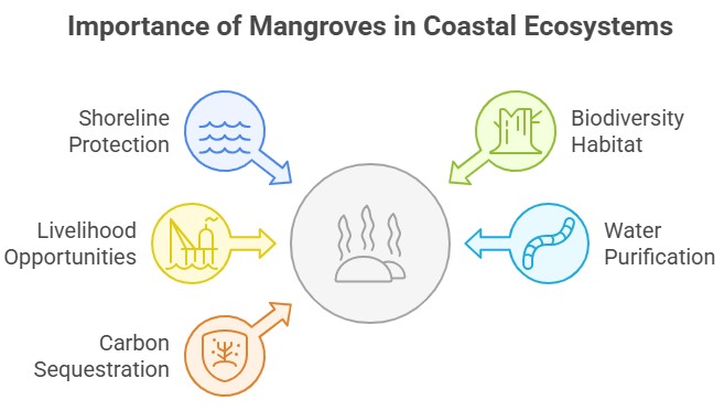
Threats to Mangroves in India
- Coastal Developments: Large tracts of mangrove forests were cleared to make way for coastal development before the importance of mangroves was appreciated. Living in coastal locations requires some land clearing, but there must be a careful balance between sustainable development and harming the local ecosystem.
- Shrimp aquaculture: Mangrove habitats unfortunately support thriving shrimp farms. Mangrove trees have been cut down as a result so shrimp ponds may be built.
- The IUCN reports that this sector has caused several nations, including Vietnam, to lose half of their original mangrove forests in recent years.
- Charcoal farming: Mangroves produce high-quality charcoal because of the density of their wood. Local inhabitants have used mangrove wood as a source of cooking fuel in many locations where mangroves are common.
- Natural Disaster: Natural disasters pose one of the biggest hazards to mangroves. Mangrove habitats are vulnerable to storms like hurricanes, tsunamis, and other natural calamities.

Government Initiatives for Mangroves in India
- Mangrove conservation and maintenance under the National Scheme began in 1987. Since 1987, the Forest Survey of India has been measuring the amount of mangroves.
- Mangroves and coral reefs are acknowledged as significant coastal environmental resources in the National Environment Policy of 2006, which also highlights the necessity of implementing an all-encompassing strategy for Integrated Coastal Zone Management.
- Mangroves for the Future (MFF), an initiative of the IUCN, has included India since 2006.
- A "National Institute for Research in Mangroves and Coastal Bioresources" was also established in West Bengal, close to the Sunderbans.
- The government implements promotional and regulatory measures to protect, conserve, and augment forests through a central sector scheme under the National Coastal Mission Programme on Mangroves and Coral Reefs.
- Further, Coastal Regulation Zone Notification implements regulatory measures under various Acts, including Environment, Wild Life, Forest, and Biological Diversity.
- The government of India has launched the Mangrove Initiative for Shoreline Habitats and Tangible Incomes (MISHTI) in Budget 2023–24, drawing on India's success in afforestation. Under this mangrove plantations will be established under this strategy along the coast and on salt pans.
Conclusion
- Serious repercussions, such as a fall in biodiversity, extinction of species, genetic erosion, greater floods, and a drop in water quality, can result from mangrove degradation.
- The government has made an effort to adopt certain programs to save these significant ecosystems, but the absence of appropriate management practices has prevented the sustainability of these resources from being accomplished.
- To preserve the biggest mangrove ecosystem in the world for both current and future generations, a sustainable management plan should be created with input from all beneficiaries and stakeholders.
35. Desertification: Causes, Impacts, Status in India & Global Solutions
Desertification is the process through which vegetation in drylands, also known as arid and semi-arid lands, such as grasslands or shrublands, declines and finally vanishes.
- The idea refers to different mechanisms that pose a danger to convert currently non-desert ecosystems into deserts, rather than the actual physical growth of existing deserts.
Causes of Desertification
- Overgrazing: The ecosystem suffers and loses its former lush splendour if there are too many animals overgrazing in certain areas since it is difficult for the plants to recover.
- Deforestation: Deforestation is a major cause of desertification, as forests are cut down for fuel, daily products, or agriculture. This leads to the loss of roots, soil support, and canopy protection, causing bare soil to dry out and turn to dust, which can be easily washed away in a single storm.
- Climate Change: Since there are various factors that might contribute to land degradation, climate change is frequently what accelerates the process of desertification in an increasing number of locations.
- Poverty and Political Instability: These issues can both be the result of and contribute to desertification. This is because individuals living in countries who are on the verge of hunger, are extremely poor, or are experiencing political unrest must immediately address their problem and do not have time to consider sustainable agricultural practices.
- Unfortunately, poor land use practices such as illegally felling trees, cultivating unsustainable crops, and grazing livestock on rapidly eroding land are frequent results of their compromised livelihoods. These practices only worsen the already precarious situation of the soil and put people's lives in danger.
- Indiscriminate of use of fertilizers: Excessive fertilizers and pesticide use can cause soil damage, causing arable land to become arid over time. Over time, this damage renders the land unsuitable for farming, making it difficult to maintain agricultural productivity.
- Poor farming practices: Farmers often struggle with land usage, stripping it of nutrients and causing desertification, leading to land loss and increased desertification in the farming area.

Impact of Desertification
- Increased vulnerability to natural disaster: Desertification worsens natural disasters by reducing ecosystem resilience and increasing vulnerability to climate change. Degraded soils increase vulnerability to flash floods, landslides, and dust storms, causing rapid floods and rapid runoff.
- Rise of famine, poverty and social conflict: Desertification is a severe land degradation that destroys natural ecosystems, causing the loss of essential services like water filtration, climate regulation, nutrient recycling, carbon sequestration, and soil regeneration.
- These services are crucial for our wellbeing and can lead to famine, water scarcity, resource conflicts, and animal deaths. Insecurity in many African countries, particularly in the Sahel area, worsens due to climate change, resource management issues, and weak political structures. This leads to hunger and conflicts.
- Species extinction: Long-lasting droughts, floods, and temperature fluctuations can deplete a species' food supply, leading to famine. In desertified areas, species that once thrived in rich environments may struggle to survive. As the environment changes, organisms must either adapt to their new climate or migrate to a more hospitable one, or they risk going extinct.
- Migration: Desertification leads to the destruction of farmers' livelihoods. The problem will be exacerbated when water scarcity due to global warming renders large areas currently used for agriculture unsuitable for agriculture. This leads to serious migration movements.
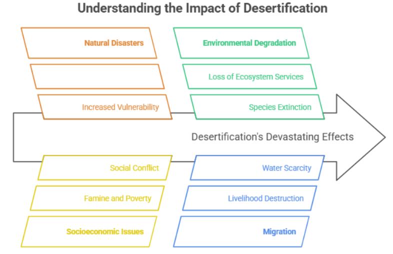
Status of Desertification in India
- According to the Desertification and Land Degradation Atlas of India, land degradation in India climbed to 84 million hectares in 2018–19 from 96.32 million hectares in 2011–2013.
- A total of 45 million hectares of degraded land were detected in three states alone, out of the 97.84 million hectares of desertified land.
- Rajasthan has 21.23 million hectares of desertified land, 14.3 million hectares in Maharashtra, and 1.02 million hectares in Gujarat.
Steps Taken by India to Combat Desertification
- Through public engagement, the National Afforestation and Eco-Development Board (NAEB) is executing the National Afforestation Programme (NAP) for the ecological restoration of degraded forests and surrounding regions.
- By engaging in plantation work in both forested and non-forested regions, the National Mission for Green India (GIM) seeks to safeguard, restore, and enhance India's forest cover.
- Projects under the National Mission on Himalayan Studies (NMHS) are used to carry out demand-driven, action-oriented research activity. A few initiatives involve the creation of models for watershed management, soil protection, and land reclamation, among other things.
- The Pradhan Mantri Krishi Sinchai Yojna's Watershed Development Component implements the Integrated Watershed Management Programme (IWMP), whose goal is to develop rainfed and degraded areas.
Global Initiatives Against Desertification
- Bonn Challenge: The Bonn Challenge is an international initiative to restore 350 million hectares of damaged and deforested land by 2030, and 150 million hectares by 2020.
- N. Convention to Combat Desertification (UNCCD): The United Nations Convention to Combat Desertification (UNCCD), which was established in 1994, is the only international treaty that is enforceable internationally and links land policy to environmental and development concerns.
- Great Green Wall Initiative: The African Union launched the game-changing Great Green Wall programme in 2007 with the goal of restoring the continent's devastated landscapes and improving the lives of millions of people in the Sahel region.
- Sustainable Development Goal 15: Protect, repair, and encourage the sustainable use of terrestrial ecosystems. Manage forests sustainably. Fight desertification. Halt and reverse land deterioration.
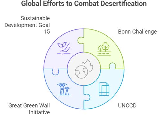
Way forward
- The best opportunity the world has to stabilize the impacts of climate change, conserve animal species, and safeguard human well-being is to stop desertification. Everybody and every government should take responsibility for protecting the forest since it is our shared obligation.
36. Soil Erosion: Causes, Effects & Prevention Methods Explained
Soil erosion is the process of wearing away the top layer of soil due to natural forces like wind and water or human activities. It poses a serious threat to agriculture, ecosystems, and water quality if not properly managed.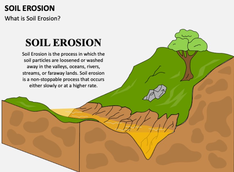
Introduction to Soil Erosion
- The erosion of the top layer of the soil which is also known as topsoil is referred to as soil erosion. Many variables influence the pace of soil erosion, including the composition of the soil, vegetation, the strength of wind and rain and anthropogenic factors.
- Soil erosion can be a sluggish process that goes unnoticed for a long time, or it can happen quickly and cause a significant loss of topsoil. Soil loss on farms may result in diminished agricultural production potential, worse surface water quality, and impaired drainage systems. Sinkholes might also be caused by soil erosion.
Causes of Soil Erosion
- Natural and anthropogenic factors contribute to soil erosion in fields, including wind and water run-offs, as well as poor farming management.
Natural Factors of Soil Erosion
- Strong winds: Heavy winds remove dry microscopic soil particles, which is a common problem in semi-arid locations, leading to desertification.
- Climate change: Abnormal rainfall or temperature swings devastate the field surface. Another consequence of climate change on soil erosion is reduced plant growth, which diminishes field cover and exposes it to rains and winds.
- Rainfall and Flooding: Excessive rain washes away topsoil particles, while huge raindrops impact the field surface and damage it with forceful splashes. Running currents during floods are another source of soil erosion.
- Wildfires: Water runoff is slowed by trees and plants. When forests or buffer zones are burned by wildfires, water streams have no impediments.
Anthropogenic Factors of Soil Erosion
- Poor Farming Practices: Soil erosion is primarily caused by poor farm management practices such as excessive fertilization, conventional tillage, mono-cropping, and overgrazing.
- Mono-cropping involves growing the same crop for multiple seasons, causing field depletion and soil erosion. Conventional tillage, such as moldboard plowing, can cause erosion in fields, while no-till farming prevents it.
- Excessive use of mineral fertilizers can lead to dehumidification and destruction of soil structure, making it more vulnerable to erosive processes. Irrigation can also cause soil erosion, especially surface irrigation, which removes nutrients and topsoil particles from uneven fields due to gravity.
- Overgrazing, a common issue, can destroy topsoil cover, but rotational grazing and cover crops can help. Terrace farming, on the other hand, prevents erosion by slowing down water streams on platforms.
- Deforestation: Any tree felling, whether for wood or to expand agricultural fields for oil palm production, might hasten erosive processes. Clear-cutting, which involves removing all or most of the trees, exposes the forestlands the most.
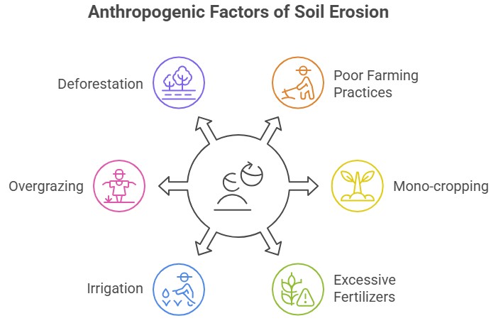
Impact of Soil Erosion
- Agriculture: Heavy machinery and overgrazing contribute to field salinization, worsening water infiltration and erosion. Over time, eroded farmlands degrade, causing negative effects like depletion of topsoil, planting material, water pollution, and acidification.
- Loss of biodiversity: Eroded lands cause vegetation decay, affecting flora and fauna, leading to ecosystem imbalance and loss of natural habitats, affecting both flora and fauna.
- Clogging and pollution: Siltation and blockage of waterways are long-term impacts of soil erosion. In addition, eroded particles choke dams and water pumps. Water currents from fields frequently carry pollutants that are harmful to humans, animals, and the environment. They also contaminate drinking water.
- Desertification: Desertification is largely caused by soil erosion. It turns the areas with a living environment into deserts. Additionally, this results in soil deterioration, biodiversity loss, and different ecological changes.
Soil Erosion Prevention Methods
- Planting vegetation, including grass, trees, and shrubs, effectively prevents soil erosion by binding soil together, reducing raindrop and wind impact, and absorbing excess water, slowing runoff and allowing infiltration.
- Applying layer of mulch protects soil from raindrops, reduces runoff, retains moisture, promotes healthier plant growth, and protects soil surface.
- Efficient irrigation practices, like drip irrigation or precision sprinklers, minimize soil runoff, prevent erosion, and maintain stability by managing timing and avoiding over-irrigation.
- Raising soil conservation awareness, educating farmers, and promoting sustainable land management practices contribute to long-term soil preservation.
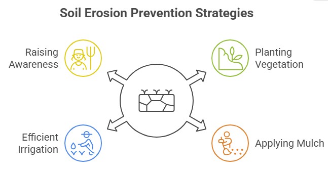
Conclusion
- It's vital to keep in mind that depending on the region, temperature, soil type, and land use practices, different solutions may be required to address soil erosion. The most successful method for preventing soil erosion and preserving this important natural resource is often to combine these measures and adapt them to the local conditions.
37. Environmental Implications of the Reclamation of the water bodies
Land Reclamation
- Land reclamation refers to changing the natural characteristics of water bodies like oceans, rivers, lakes, or marshes. By transforming marshes or other bodies of water, it might happen inland or along coasts.
- Mumbai, Spain, New York and Palm Jumeirah(UAE) are all prominent examples of reclaimed land.
- Traditional land reclamation involved dikes enclosing tidal marshes, draining to create dry land, and introducing sediment and soil from the mainland, gradually expanding the land into the sea.
- Modern land reclamation methods involve large-scale engineering projects using offshore concrete barrier walls filled with sand, earth, clay, or rock, or hydraulic reclamation using dredged soil mixed with water.
Impact of land reclamation
- Coastal Flooding: Storm surges, the cumulative impacts of global warming and land subsidence, and a sizable percentage of reclaimed land are all at high danger of flooding. This puts the communities live in the recently recovered regions at danger.
- Habitat Destruction: Materials like sand are frequently obtained from river and marine settings for use in land reclamation. The removal of these resources may result in the loss of numerous creatures' habitats and spawning grounds.
- Degradation of water quality: Water bodies are important for controlling neighbourhood water systems, and filling them in can cause these systems to become unbalanced and affect the quantity and quality of water.
- Environmental Disaster: Reclamation of water for urban land use in coastal locations may increase the frequency of earthquakes and other natural disasters.
Solutions
- Ramsar Convention: Strict implementation of Ramsar Convention. The reclamation should be prohibited in the notified wetlands of international importance.
- Environmental Impact Assessment: Since reclamation of water bodies for urban use has severe impact thus thereby environmental impact assessment for such activity must be made mandatory.
- Habitat restoration: Implement compensatory actions to repair or develop alternative habitats in water bodies to boost biodiversity and reduce natural habitat loss.

Conclusion
- Water bodies provide a wide range of essential resources and ecosystem services, including food, water, fibre, flood mitigation, storm protection, carbon sequestration, and climate regulation, in addition to supporting high concentrations of biodiversity etc. Thus, it is essential to preserve them and promote a more sustainable method of development.
38. Forest Resources in India: Importance, Current Status & Conservation
Forests are critical to India’s ecology, economy, and climate, covering nearly a quarter of the country’s land. They support biodiversity, indigenous communities, and act as major carbon sinks vital for climate stability.
Introduction to Forest Resources in India
- The word "forest resources" refers to the various sorts of resources that forests supply, such as wood, timber, bushmeat, pharmaceuticals, etc. A thick growth of trees and other plants that occupies a sizable area of land is known as a A group of plants and animals interacting with one another and their surroundings is called an ecosystem.
- The study, preservation, and management of forests are all part of the science of forestry. On Earth, forests dominate the terrestrial biosphere. Only five nations—Brazil, Canada, China, the Russian Federation, and the United States of America—are home to more than half of the world's woods.
- Tropical latitudes have the highest proportion of forests (45%), followed by boreal, temperate, and subtropical domains. Forests significantly impact the planet's life, protecting biodiversity and positively affecting climate.
Significance of Forest Resources in India
For Humans
- Over 1.6 billion people rely on forests for food and fuel, with 70 million people worldwide, including Indigenous communities, calling them home. These forests provide oxygen, shelter, jobs, water, nourishment, and fuel.
- The fate of forests may determine our own fate, as they prevent erosion, enrich soil, protect communities from landslides and floods, and produce topsoil for crops. They also play a crucial role in the global water cycle, releasing water vapor and capturing rainfall, and filtering out pollution and chemicals.
- The destruction of forests impacts agriculture and food production, and human health is closely linked to forest health. Deforestation increases the risk of diseases from animals to humans, while time spent in forests has been shown to improve conditions like cardiovascular disease, respiratory concerns, diabetes, and mental health.
For Nature
- Forests are home to 80% of terrestrial biodiversity, including 80% of amphibians, 75% of birds, and 68% of mammals. Deforestation in tropical forests can result in the loss of up to 100 species daily.
- Therefore, stopping biodiversity loss is crucial, as it disrupts the entire ecosystem and threatens iconic species like the tiger, giant panda, gorilla, and orangutan.
- Habitat loss is a major cause of biodiversity loss, with forest-dwelling wildlife populations declining by an average of 69% since 1970, particularly in tropical forests like the Amazon.
For Climate
- Forests are the largest carbon storehouses, absorbing greenhouse gas from the air and locking it away. Cutting down or damaging forests releases carbon emissions that contribute to the climate crisis. However, forests also protect people and nature from the consequences of a warming world.
- As climate change impacts, such as floods and storms, become more frequent and severe, forests provide a crucial buffer for communities. Extreme events like wildfires limit the ability of forests to regenerate, while deforestation increases the risk of fires. Therefore, stopping deforestation and restoring forests is a crucial part of climate action.

Status of Forest Resources in IndiaThe total forest and tree cover in the country is 80.9 million hectares, covering 24.62 percent of the country's geographical area. In comparison to 2019, there has been an increase of 2,261 sq km in forest cover, with 1,540 sq km in forest cover and 721 sq km in tree cover.
Odisha, Maharashtra, and Karnataka show the highest mangrove cover increase. The country's total carbon stock is estimated to be 7,204 million tonnes, with an annual increase of 39.7 million tonnes. |
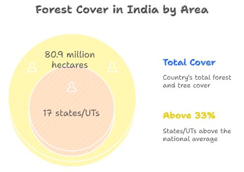
Conclusions
India's forests hold immense ecological, cultural, and economic significance, supporting diverse ecosystems and supporting indigenous tribal communities. They contribute to the rural economy, mitigate climate change, and attract tourists. Therefore, there is a need of collaborative effort from India's government, organizations, and local communities to conserve and sustainably manage forests, ensuring their preservation for future generations.
39. Social Forestry in India: Types, Benefits, and Government Initiatives
The practice of managing forests for the benefit of local communities is known as social forestry. It entails activities like forest management, forest protection, and afforestation of deforested lands with the aim of enhancing rural, environmental, and social development.
Objective of Social Forestry
- The primary objective of social forestry is to expand the number of trees and plantations to satisfy people's increasing demands for wood, food, fuel, and other necessities while easing strain and dependence on traditional forest regions. It also attempts to safeguard agriculture from unfavorable climatic circumstances.
- Social forestry is an idea and a practice that has been around for centuries, but because of its advantages, such as its capacity to address the problems caused by global warming, it is continuously acquiring new dimensions.
Types of Social Forestry
- Agro-forestry: Agro-forestry combines tree growth and agriculture to provide commercial agricultural and tree products. It can be separate or fully integrated within a single business enterprise, offering economic, social, and ecological benefits.
- This social forestry is ideal for individuals looking to venture into farm forestry while maintaining existing agricultural enterprises.
- Farm forestry: Farm forestry aims to manage trees for specific purposes within a farming context, typically timber plantations on private land. This setup can be applied to various enterprises using different tree parts.
- Benefits include animal shelter, diversified earnings, improved living environments, increased plantation capital value, soil and water health improvement, sustainable natural resource management, and biodiversity enhancement.
- Extension forestry: Urban areas and the majority of dwelling estates are becoming more and more commonplace for extension forestry. Trees are planted along the edges of canals, highways, railroads, and wastelands as part of extension forestry.
- This kind of social forestry is helpful in establishing woods on public wastelands, panchayat properties, and common village lands.
- Community forestry: Community forestry involves village members collectively managing community land, involving the local population in planning, managing, and harvesting forest crops.
- This approach aims to increase involvement and reward local people while balancing between outside and community interests.

Advantages of Social Forestry
- Biodiversity enrichment: Tree growth in community lands increases biodiversity value, providing habitat for various animals, plants, and wildlife. Social forestry benefits by providing food, shelter, and promoting plant growth, increasing food varieties for animals and local people.
- Carbon removal: Trees are crucial in the process of removing carbon from the environment, which helps to combat the effects of global warming. As they expand, trees absorb carbon dioxide from the air and so remove it.
- The most effective approach to cut carbon dioxide in urban areas is thought to be social forestry. By lowering the demand for power, it also indirectly cuts carbon dioxide emissions.
- Soil conservation: Social forestry benefits communities by promoting soil conservation, improving agricultural activities, and preventing soil erosion through tree roots holding soil in place.
- Improve air quality and health: Trees not only remove carbon dioxide from the environment but also improve air quality. An acre of trees generates enough oxygen for up to 18 people and absorbs harmful gases, reducing health issues like asthma and breathing difficulties.
Disadvantages of Social Forestry
- Social forestry plantations often choose species that are inappropriate for the ecological setting.
- Indian farmers often oppose social forestry due to their small landholdings and lack of agricultural insurance and marketing assistance.
- Social forestry in India has been diverted from agricultural land for incentives that threaten food security and agriculture.
- Lack of private sector participation.
- Women are excluded, and communities and farmers view it as a cash-generating exercise rather than meeting basic needs.
Social Forestry Initiatives by India
- Through initiatives and programmes like Nagar Van Yojana, School Nursery Yojana, Compensatory Afforestation Fund Management and Planning Authority (CAMPA), National Afforestation Programme (NAP), National Mission for a Green India (GIM), etc. that encourage urban forestry, tree plantation on vacant lands, and bunds on farm lands, among other things, the Ministry of Environment, Forest, and Climate Change promotes plantation throughout the nation, including various metropolitan cities.
Conclusion
- The Gandhian concept of economic growth and community development includes social forestry as a critical component. The social advantages and the extra resources produced in this way might act as stepping stones on the road to self-sufficiency.
- Further, it also offers several elements for agricultural growth and development as India's heavily reliant on agriculture economy seeks diversification. To overcome obstacles and promote the cause of social forestry, all stakeholders—including the public and private sectors—must collaborate.
40. Earthquakes in India: Causes, Effects, Zones, and Mitigation Strategies
An earthquake is a violent and abrupt shaking of the ground, caused by movement between tectonic plates along a fault line in the earth's crust. Earthquakes can result in ground shaking, soil liquefaction, landslides, fissures, avalanches, fires, and tsunamis.
|
- Focus and Epicentre: The initial point of energy release is the focus, and the surface point above it is the epicenter.
- Foreshocks and Aftershocks: Major earthquakes often involve minor aftershocks and sometimes have preceding foreshocks.
- Swarms: Clusters of small earthquakes are called swarms and often indicate impending volcanic activity.
Causes of Earthquakes in India
- Fault Zones: Most shallow earthquakes result from stress release along fault ruptures in the earth's crust.
- Plate Tectonics: Earthquakes can occur due to slipping of land along fault lines in convergent, divergent, and transform boundaries.
- Volcanic Activity: Less severe earthquakes can be caused by volcanic activity, which can serve as early warning signs of eruptions.
- Human-Induced Activity: Human activities like mining or reservoir construction can cause minor earthquakes.
Focus Depth of Earthquakes in India
- Shallow Focus: Shallow earthquakes occur at depths of 0-70 km.
- Intermediate Focus: These earthquakes occur at depths of 70-300 km.
- Deep Focus: Deep-focus earthquakes occur at depths of 300-700 km.
Distribution of Earthquakes in India
- Circum-Pacific Belt: This is the major earthquake belt, affecting coastal regions around the Pacific Ocean.
- Alpine Belt: A significant belt of seismic activity that includes the Himalayas and Alps.
- Oceanic Ridges and Rift Valleys: Seismic activity also occurs along oceanic ridges and rift valleys in the Arctic Ocean, Atlantic Ocean, western Indian Ocean, and East Africa.
Impact of the Earthquakes in India
|
Impact of Earthquakes |
Description |
|
Shaking and Ground Rupture |
Damage to rigid structures, major risk to large engineering structures. |
|
Landslides and Avalanches |
Can result from earthquakes, causing slope instability. |
|
Fires |
Caused by damage to electrical power or gas lines; can result in more fatalities than the quake itself. |
|
Soil Liquefaction |
Transforms water-saturated soil from solid to liquid, causing structures to tilt or sink. |
|
Tsunami |
Megathrust quakes can move large water volumes, producing long-wavelength, long-period sea waves. |
|
Floods |
Secondary effects of earthquakes due to dam damage or landslips that dam rivers. |
Seismic Zoning Map

Credit: Maps of India
NDMA Guidelines for Earthquakes in India
- Earthquake-Resistant Design and Construction of New Structures: Encourage the building of earthquake-resistant structures in seismic-prone areas, ensuring strict adherence to regulations and building codes. This includes educating future engineers and architects about these techniques.
- Seismic Strengthening and Retrofitting of Lifeline and Priority Structures: Perform a structural safety audit and retrofit select critical lifeline structures and high-priority buildings in seismic Zones III, IV, and V, based on risk, potential loss of life, and financial implications.
- Regulation and Enforcement: Periodically revise the codes and standards related to earthquake-resistant construction to keep up with international practices. Ensure codes developed by other regulatory bodies are updated with current state-of-the-art techniques.
- Awareness and Preparedness: Implement a comprehensive awareness campaign to educate the public about safe practices before, during, and after an earthquake, emphasizing the seismic risk and vulnerability of the states.
- Creation of Public Awareness on Seismic Safety and Risk Reduction: Develop and distribute educational materials such as a handbook on earthquake safety, a homeowner's seismic safety manual, and a manual on structural safety audit of infrastructure. Create videos and translate these resources into regional languages for wider reach.
- Capacity Development (Including Education, Training, R&D, and Documentation: Improve the quality of education materials, field training, and teaching at all levels, focusing on capacity and skills development. Encourage research, teaching, and training that contribute to improving earthquake education in India.
- Response: Develop coordinated, prompt, and effective response systems at the district and community levels. Consider the multi-hazard scenario of various regions to optimally utilize resources and strengthen emergency response capabilities.
Challenges in India’s Preparedness for Earthquakes in India
- Retrofitting in hilly and mountainous areas, which constitute the majority of earthquake-prone zones, is both challenging and costly.
- There's a significant deficit of skilled labor proficient in designing and building structures that can withstand earthquakes.
- A competency-based licensing system for structural engineers is not yet formally established.
- Compliance with building codes is lax, leading to a disregard for necessary safety requirements.
- As per NDMA, nearly 4,000 multistory buildings in Ahmedabad may not survive a severe earthquake due to inferior design.
- The mechanism for fund collection during disasters lacks standardization, and awareness about the national disaster relief fund is insufficient.
- The flood response coordination in Uttarakhand exposed deficiencies in the disaster response system.
- Current efforts to generate awareness and train local communities for post-disaster operations are inadequate.
Prevention and Mitigation of Earthquakes in India
Long-term measures
- Re-framing buildings' codes, guidelines, manuals, and bylaws and their strict implementation.
- Incorporating earthquake-resistant features in all buildings in high-risk areas.
- Constructing earthquake-resistant community buildings, especially in seismic zones of moderate to higher intensities.
- Supporting R&D in various aspects of disaster mitigation, preparedness and prevention, and post-disaster management.
Medium-term measures
- Retrofitting of weak structures in highly seismic zones.
- Preparation of disaster-related literature in local languages with dos and don'ts for construction.
- Getting communities involved in the process of disaster mitigation through education and awareness.
- Networking of local NGOs working in the area of disaster management.
Important institution to prevent and mitigate earthquake loss
|
Conclusion
Earthquake vulnerabilities can be reduced due to integrated approaches at international, national, and local levels. Education to people about earthquake safety and preparedness, including how to evacuate safely and what to do during an earthquake is essential. With this Implement early warning systems that can alert people of an impending earthquake, giving them time to evacuate or take other safety measures. And at last Develop emergency response plans that outline the actions to be taken in case of an earthquake, including evacuation procedures and contingency plans for power restoration and other critical infrastructure.
41. Cyclones: Types, Causes, Formation, Impacts & Safety Measures Explained
A cyclone is a large, rotating storm system with low pressure at its center. Cyclones can form in any ocean basin, but they are most common in the tropics. Cyclones can cause a variety of hazards, including strong winds, storm surges, and heavy rainfall.
Types of Cyclones
- Tropical cyclones: These are the most common type of cyclone. They form over warm, tropical oceans and are characterized by strong winds, heavy rainfall, and storm surges.
- Extratropical cyclones: These cyclones form over cooler waters and are not as strong as tropical cyclones. They are characterized by strong winds, heavy rainfall, and snow.
- Midlatitude cyclones: These cyclones form in the midlatitudes and are characterized by strong winds, heavy rainfall, and snow.
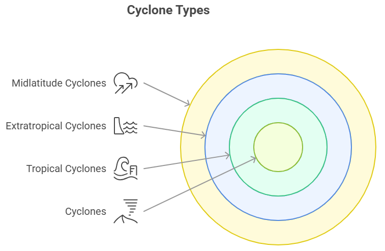
Causes of Cyclones
- Warm Ocean Waters: Cyclones form over warm tropical or subtropical ocean waters with a sea surface temperature exceeding 26.5°C (80°F), providing energy and moisture for their formation and intensification.
- Coriolis Effect: Earth's rotation causes the Coriolis effect, deflecting air as it moves from high to low pressure. In the Northern Hemisphere, it causes a counterclockwise rotation in cyclones, while in the Southern Hemisphere, it leads to a clockwise rotation.
- Low Vertical Wind Shear: Cyclones require low vertical wind shear, which is a minimal change in wind speed and direction with height.
- This enables the storm system to maintain its structure and promotes the organization of thunderstorms around the center. High wind shear disrupts cyclone development and intensification.
- Moisture and Instability: Cyclones thrive in environments with abundant moisture and atmospheric instability. The rise of warm, moist air creates convection currents and thunderstorms.
- As the air rises, it cools and condenses, releasing latent heat that further fuels cyclone energy and intensification.
- Atmospheric Convergence: Cyclones form where air masses with different properties, such as temperature and humidity, converge, causing atmospheric convergence.
- This convergence leads to the upward movement of air and the development of a low-pressure center, which is essential for cyclone formation.
- Tropical Disturbances: Cyclones often originate from tropical disturbances, which are areas of organized thunderstorms with weak pressure gradients. Under favorable conditions, these disturbances can evolve into tropical depressions, storms, and eventually cyclones.
- Seasonal Variations: Cyclone formation is influenced by seasonal variations. Specific times of the year, known as the hurricane or cyclone season, are characterized by favorable oceanic and atmospheric conditions for cyclone development.
- This season typically occurs in regions such as the Atlantic Ocean, the Caribbean Sea, and the eastern Pacific Ocean.
Formation of Cyclones
- Warm ocean temperatures: Cyclones thrive on warm waters with temperatures above 26.5°C (80°F) as they serve as a primary source of energy for their formation and intensification.
- Favorable atmospheric conditions: The presence of a pre-existing weather disturbance, such as a tropical wave or low-pressure system, can provide the initial trigger for cyclone development. Additionally, low vertical wind shear is crucial for cyclone formation and maintenance.
- Moisture and instability: Sufficient moisture in the lower atmosphere and unstable atmospheric conditions contribute to the development of thunderstorms, which are the building blocks of a cyclone.
As a cyclone develops, it undergoes different stages, including tropical depression, tropical storm, and eventually reaching hurricane/typhoon/cyclone intensity. The warm ocean waters provide the energy needed for the cyclone to strengthen, and the rotation of the Earth causes the system to spin and develop a distinct eye at its center.

Impact of Cyclones
Cyclones can have significant impacts on the areas they affect
- Strong winds: Cyclones are characterized by powerful winds that can cause extensive damage to buildings, infrastructure, and vegetation.
- These winds can reach speeds exceeding 119 kilometers per hour (74 mph) in tropical storms and much higher in severe hurricanes/typhoons/cyclones.
- Heavy rainfall and flooding: Cyclones bring intense rainfall, which can lead to flash floods and river flooding. The heavy precipitation can cause landslides, damage crops, and disrupt water and sanitation systems, increasing the risk of waterborne diseases.
- Storm surge: It is a coastal flood or rise in sea level caused by the strong winds and low atmospheric pressure of a cyclone. It can inundate coastal areas, erode shorelines, and result in significant damage and loss of life.
- Tornadoes and water spouts: Cyclones can also spawn tornadoes or water spouts, which are rapidly rotating columns of air. These tornadoes can cause additional localized destruction.
Recent Cyclones
|
Safety Measures for Cyclones
- Early warning systems: Meteorological agencies monitor and track cyclones using satellites, weather radar, and other tools. Timely warnings and alerts are crucial for providing advance notice to people in the affected areas.
- Evacuation plans: Local authorities develop evacuation plans to relocate residents from high-risk areas to safer locations. This includes identifying evacuation routes, establishing shelters, and organizing transportation.
- Infrastructure preparedness: Constructing buildings and infrastructure that are designed to withstand cyclonic winds and storm surge can help minimize damage. Strengthening roofs, windows, and doors, and ensuring proper drainage systems can also be effective.
- Community awareness and education: Educating communities about cyclones, their impacts, and necessary safety measures can help people understand the risks and take appropriate actions. This includes teaching individuals how to secure their property, stock essential supplies, and develop personal emergency plans.
- Relief and recovery operations: Adequate preparations should be made for post-cyclone relief and recovery operations, including providing medical assistance, restoring essential services, and facilitating the distribution of food, water, and other necessities.
It's important to note that cyclones are natural disasters that require careful monitoring, preparedness, and coordinated responses from governments, communities, and individuals to minimize the potential damage and ensure the safety of those in their path.
Climate change is predicted to increase the frequency and intensity of extreme weather events, including cyclones. Therefore, continuous investment in research and development, capacity building, climate-resilient infrastructure, and proactive policy-making is essential for India to navigate towards resilience against the growing threat of cyclones. Emphasizing a multidisciplinary and holistic approach encompassing technology, environmental management, and community engagement is critical to combat the cyclone menace and safeguard the lives and livelihoods of millions of Indians.
42. El Niño, La Niña, and ENSO
Niño
- El Niño refers to the warming of seawater in the central-east Equatorial Pacific that happens every few years. During El Niño, surface temperatures in the equatorial Pacific rise, and trade winds weaken.
- Normally, easterly trade winds blow from the Americas towards Asia, but during El Niño, they change direction and become westerlies, bringing warm water from the western Pacific towards the Americas.
- El Niño occurs every 3-6 years and lasts for about 9-12 months. It can cause droughts, flooding, and changes in temperature.
- El Niño can lead to below-normal rainfall, impacting India's agricultural sector.
Outcomes of El Niño
- Disruptions in the food chain: The reduction of upwelling and phytoplankton due to El Niño affects fish and organisms higher up the food chain.
- Disruptions in the overall ecosystem: Warm waters carry tropical species towards colder areas, disrupting multiple ecosystems.
- Alterations in wind and weather patterns: Changes in Pacific temperature and wind patterns affect global weather, causing dry, warm winters in Northern U.S. and Canada, increased flooding risk in the U.S. Gulf Coast and Southeastern U.S., and drought in Indonesia and Australia.
La Niña
- La Niña is characterized by cooler than average sea surface temperatures in the equatorial Pacific region.
- Trade winds during La Niña are stronger than usual, pushing warmer water towards Asia.
- It is the colder counterpart of El Niño and occurs when ocean temperatures in the equatorial Pacific drop to lower-than-normal levels.
Outcomes of La Niña
- Upwelling increases on the American west coast, bringing nutrient-rich water to the surface.
- Pacific cold waters near the Americas push jet streams northwards, leading to drier conditions in Southern U.S. and heavy rainfall in Canada.
- La Niña has been associated with heavy floods in Australia, as seen in the past two years.
El Nino and Southern Oscillation (ENSO)
- El Niño–Southern Oscillation (ENSO) refers to irregular variations in winds and sea surface temperatures over the tropical eastern Pacific Ocean.
- Surface waters across the tropical Pacific Ocean warm or cool by 1°C to 3°C compared to normal every three to seven years.
- The warming phase is El Niño, and the cooling phase is La Niña. El Niño and La Niña are opposite phases of the ENSO cycle, impacting ocean processes, weather, and climate globally.
Impact on Cyclone Formation and Monsoons in 2023
El Niño and Monsoon Deficit
- A transition from La Niña winter to El Niño summer typically leads to a large monsoon deficit of around 15%.
- Weaker pre-monsoon and monsoon circulations and weaker vertical shear favor enhanced cyclone formation.
- However, sub seasonal variability in sea-surface temperature and winds also plays a role in cyclogenesis over the northern Indian Ocean. Overall, cyclogenesis tends to be subdued during an El Niño year.
Monsoon Deficit in 2023
- If an El Niño state emerges by summer, India is likely to experience a deficit monsoon in 2023.
- The Indian Ocean dipole may compensate for the negative effects of El Niño, but the relation between the dipole and the summer monsoon is not fully understood.
Vagaries of Monsoon
- Pre-monsoon cyclones are affected by warming in the Arctic region, potentially impacting the onset of the summer monsoon.
- Heavy rains and high river runoffs in the Bay of Bengal contribute to surface warming in the Arabian Sea, creating favorable conditions for cyclone formation if circulation and vertical shear are weak.
|
Government Steps to Mitigate the Impact of El Niño
- Pradhan Mantri Fasal Bima Yojana (PMFBY): Crop insurance scheme to protect farmers from crop loss due to natural calamities, including drought, floods, and weather-related events.
- Mission Amrit Sarovar: Scheme to develop 75 ponds in each district to reduce dependence on rainfall.
- Soil Health Card scheme: Promotes soil testing to help farmers better manage crops during droughts or weather-related events.
- National Food Security Mission (NFSM): Aims to increase crop productivity in rainfed areas through better farming practices and technology adoption.
- National Watershed Development Project for Rainfed Areas (NWDPRA): Promotes sustainable watershed management to improve soil moisture and water availability during drought periods.
- National Agricultural Insurance Scheme (NAIS): Provides financial assistance to farmers in case of crop loss due to natural calamities, including drought and weather-related events.
- Rashtriya Krishi Vikas Yojana (RKVY): Aims to promote agriculture development, including rainfed agriculture and modern technologies for improved crop productivity during drought periods.
- Pradhan Mantri Krishi Sinchai Yojana (PMKSY): Promotes efficient use of water resources in agriculture to deal with drought and weather-related events, increasing water use efficiency.
43. Tsunami: Causes, Effects, Warning Systems, NDMA Guidelines in India
"Tsunami," from Japanese, means "Harbour wave." It's a series of large, long-wavelength waves in large bodies of water caused by major disturbances above or below the surface, or due to significant water displacement. Despite the name "tidal wave," lunar and solar gravitational forces do not cause tsunamis.
Causes of Tsunami
- Tsunamis can occur due to earthquakes, volcanic eruptions, landslides, underwater explosions, and meteorite impacts. Notable subduction zones causing tsunamis include those off Chile, Nicaragua, Mexico, and Indonesia.
Formation of Tsunami Waves
- Tsunami waves are formed by significant seabed displacements, such as in megathrust earthquakes, marine volcanic eruptions, or submarine landslides. Extra-terrestrial objects falling onto Earth can also cause destructive tsunamis.
- Wave propagation includes gravity acting to return the sea surface to its original shape, creating ripples that race outward. As tsunamis enter shallow waters, they slow down and increase in height (shoaling effect). Tsunamis can appear suddenly and may involve several waves at intervals of several minutes.
- Tsunami properties include wave crest, trough, height, amplitude, period, wavelength, and frequency. Normal waves involve horizontal (ocean currents and waves) and vertical (tides) motion, with the actual motion of the water beneath the waves being circular.
- Tsunami warning systems can provide a three-hour notice of a potential tsunami following an earthquake. These systems monitor changes in water pressure, with data being transmitted to warning centers for analysis and issuing of warnings.

|
The Indian Tsunami Early Warning System (ITEWS) established in 2007 is an integrated network of seismic stations and tide gauges, with an operational warning center to detect tsunamis and provide timely advisories. Indian scientists can issue a tsunami warning within 10-20 minutes after an earthquake. |
NDMA Guidelines on Tsunami
- NDMA (National Disaster Management Authority) has developed guidelines to manage the risk of tsunamis through awareness generation, capacity building, education, training, and research & development.
- The guidelines highlight the importance of effective dissemination of tsunami alerts and warnings to the appropriate agencies and vulnerable coastal communities, coordinated by the Indian National Center for Ocean Information Services.
- The Bureau of Indian Standards is urged to roll out construction standards for tsunami-resistant designs of structures. These standards would guide new constructions and protection strategies for key infrastructure along the seafront.
- The guidelines advocate for a robust techno-legal regime involving efficient land-use practices, bio shields, shelterbelt plantation, and mangrove regeneration, all with community involvement.
- They call for a robust emergency response mechanism involving civil defense volunteers, home guards, State Disaster Response Forces, and the National Disaster Response Force.
- The guidelines emphasize the importance of conducting exercises that include tsunami scenarios to enhance the efficiency and effectiveness of disaster management during an actual event.
- Finally, they explore the provisions of the Disaster Management Act 2005 to mainstream the concern of tsunami risk management in disaster management plans at various levels.
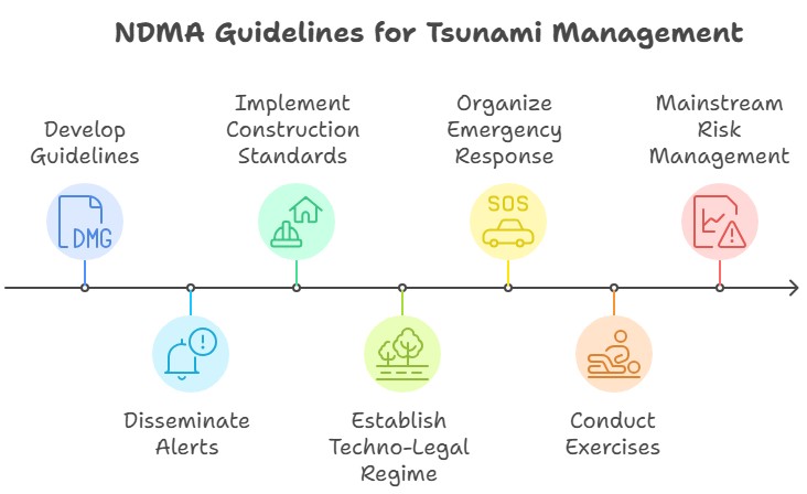
44. Landslides
Landslide, also called landslip, is the movement of a mass of rock, debris, earth, or soil (soil being a mixture of earth and debris). Landslides occur when gravitational and other types of shear stresses within a slope exceed the shear strength (resistance to shearing) of the materials that form the slope.
|
LANDSLIDES AND INDIA
|
Causes of Landslide:

Hazard Zonation Mapping As A Critical Tool For Landslide Disaster Mitigation:
- Identification of Risk Areas: The primary objective of hazard zonation mapping is to identify and categorize regions based on their potential risk to landslides. This helps to prioritize areas needing immediate mitigation measures and to establish early warning systems.
- Planning and Development: It guides planners, developers, and policymakers in making informed decisions about land use, zoning laws, building codes, and urban planning by providing a visual representation of areas susceptible to landslides.
- Infrastructure and Construction Design: The information obtained from hazard zonation mapping can help in designing infrastructure and buildings that can withstand the impacts of landslides. Engineers can incorporate these data into the design and construction of roads, bridges, and other critical infrastructure.
- Emergency Preparedness and Response: Zonation mapping can facilitate the planning of evacuation routes and emergency response strategies, ensuring that they are effective and efficient during a landslide event.
- Insurance and Investment Decisions: Insurance companies can use this information to determine risk and set premiums for property insurance. Similarly, investors and homeowners can make informed decisions about where to invest or purchase property.
- Education and Awareness: Hazard zonation maps can also be used to increase public awareness about landslide risks, helping communities to understand and prepare for potential landslide events.
- Environmental Protection: These maps can help identify areas where deforestation, excessive groundwater extraction, or other human activities might increase landslide risks, thereby informing policies to protect these areas.
- Long-Term Monitoring and Research: Hazard zonation mapping can assist in long-term monitoring of landslide-prone areas and provide valuable data for further research into landslide patterns and mitigation strategies.
National Landslide Risk Management Strategy of India by NDMA:
- Landslide Hazard Zonation: The strategy emphasizes the need to strengthen and validate landslide zoning maps. It proposes using advanced tools such as Unmanned Aerial Vehicles (UAVs), Terrestrial Laser Scanners, and high-resolution Earth Observation data. The document suggests creating maps at macro (1:50,000 / 25,000) and meso (1:10,000) scales and implementing monitoring and quality-checking mechanisms.
- Landslide Monitoring and Early Warning System: The document highlights previous work, identifies gaps, and suggests future prospects, including the development of rainfall thresholds, Numerical Weather Prediction (NWP), Automatic Rain Gauges, Wireless Sensor Networks (WSN), and Micro-Electro-Mechanical Sensors (MEMS).
- Awareness Programmes: The strategy underscores the importance of raising awareness and preparedness through community engagement. The objective is to help communities take preventive measures and respond effectively in case of an emergency.
- Capacity Building and Training: The document recommends conducting a nationwide Training Need Assessment (TNA) in Landslide Risk Management, including new technology for capacity building and training programs. It emphasizes the need to strengthen the response framework at the grassroots level.
- Mountain Zone Regulations and Policies: The strategy suggests formulating land-use policies and a techno-legal regime, updating and enforcing building regulations, reviewing and revising BIS codes/guidelines for landslide management, and amending town and country planning legislations for natural hazard-prone areas.
- Stabilization and Mitigation of Landslides: The document details the need for specific land-use policies, enforcement of building regulations, and proposed amendments in town and country planning legislations in landslide-prone areas.
- Creation of Special Purpose Vehicle (SPV) for Landslide Management: The strategy mentions efforts made by the Task Force, including pilot projects for landslide hazard zonation maps, low-cost landslide monitoring solutions, training and capacity building initiatives, and the proposed creation of a "Centre for Landslide Research Studies and Management".
The strategy aims to mainstream landslide disaster risk reduction (DRR) in disaster management activities, providing guidance for States/UTs, Ministries/Departments, and other stakeholders in their developmental projects, and serving as a guidebook for SDMAs/DDMAs in their disaster risk management initiatives.
Government initiative
- In India, the Ministry of Environment, Forest and Climate Change (MoEFCC) is responsible for landslide management.
- National Landslide Susceptibility Mapping (NLSM) project to identify landslide-prone areas in the country.
- The Geological Survey of India (GSI) and the Central Water Commission (CWC) are also involved in landslide management in India.
- NDMA guidelines on landslide disaster management.
45. Landslide Atlas of India
Introduction
- The Landslide Atlas of India has been released by the National Remote Sensing Centre (NRSC) under the Indian Space Research Organization (ISRO).
- NRSC is responsible for remote sensing satellite data acquisition, processing, archiving, and dissemination.
Preparation of the Atlas
- Scientists conducted a risk assessment based on 80,000 landslides recorded between 1998 and 2022 in 147 districts across 17 states and two Union Territories.
- The atlas utilized satellite data from ISRO to map seasonal and event-based landslides, including major incidents like the Kedarnath disaster in 2013 and landslides triggered by the Sikkim earthquake in 2011.
- The pan-India landslide database categorized landslides into seasonal (2014 and 2017 monsoon seasons), event-based, and route-based (2000-2017).

Key Highlights of the Atlas
- Uttarakhand, Kerala, Jammu and Kashmir, Mizoram, Tripura, Nagaland, and Arunachal Pradesh reported the highest number of landslides between 1998 and 2022.
- Mizoram recorded the highest number of landslide events, with 12,385 in the past 25 years, out of which 8,926 occurred in 2017 alone.
- Uttarakhand followed with 11,219 landslides, and Kerala also reported a significant number. Recent land subsidence events in Joshimath highlighted Uttarakhand's vulnerability.
- Districts with the highest landslide exposure are in Arunachal Pradesh (16), Kerala (14), Uttarakhand and Jammu and Kashmir (13 each), Himachal Pradesh, Assam, and Maharashtra (11 each), Mizoram (8), and Nagaland (7).
- Rudraprayag and Tehri Garhwal districts in Uttarakhand have the highest landslide density and risk exposure in the country.

Way-forward:
- Experts recommend halting all development and hydroelectric projects in Joshimath to prevent further environmental degradation.
- An immediate plan is needed to relocate residents to safer locations, considering new variables and the changing geographical factors.
- The town's drainage and sewer system requires comprehensive study and redevelopment as the current poor management leads to soil degradation.
- Replantation, especially at vulnerable sites, is advised to improve soil capacity, requiring a coordinated effort between government, civil bodies, and military organizations such as the Border Roads Organisation (BRO).
- There's a need to enhance the coverage of the existing weather forecasting technology for improved local event predictions.
- The government should prioritize scientific studies explaining the causes behind the current crisis and reconsider the pace and nature of development in the area.
46. Floods
Floods occur when a stream's discharge surpasses the capacity of its channel, causing excess water to flow over the banks and submerge the surrounding dry land.
Causes of Floods:
- Natural Causes: These include heavy rainfall, cloud bursts, snow and ice melt, changes in river systems and catchment areas, sediment deposition in river beds, dam collapses, sea transgression during tropical cyclones, and tsunamis and landslides along rivers.
- Anthropogenic Causes: These include deforestation (causing soil erosion and river silting), improper land use and farming practices (leading to soil and water flushing into rivers), and increased urbanization (reducing land's ability to absorb rain due to impermeable surfaces).
Consequences of Floods:
- Negative Consequences: These include loss of life and property, agricultural disruption, habitat changes and destruction, disruption of communication and essential services, and the spread of water-borne diseases.
- Positive Consequences: Floods can deposit fertile silt on agricultural fields, enhancing crop growth, and recharge groundwater levels.
Flood Distribution in India:
- In India, floods are a recurrent phenomenon affecting 12% (40 million hectares) of the country's geographical area.
- The most affected areas include Bihar (27% damage), Uttar Pradesh and Uttarakhand (33% damage), and Punjab and Haryana (15% damage). The Ganges-Brahmaputra-Meghna Basin accounts for nearly 60% of the country's total river flow and is a significant flood area.
- Other vulnerable regions include the Brahmaputra, Ganga, and Northwest River Regions, as well as Central and Deccan India. Due to their shallow basins, peninsular rivers and the eastern coasts, which are prone to cyclones, are also flood-prone.
47. Cloudbursts in India: Causes, Impact & Climate Change Link
A cloudburst is a sudden and intense rainfall event over a small geographical area, often leading to flash floods and landslides. In India, these events are common in hilly regions like the Himalayas and are becoming more frequent due to climate change.
What are Cloudbursts?
A cloudburst is a localised but intense rainfall activity. Short spells of very heavy rainfall over a small geographical area can cause widespread destruction, especially in hilly regions where this phenomenon is the most common.
- Not all instances of very heavy rainfall, however, are cloudbursts.
- A cloudburst has a very specific definition:
- Rainfall of 10 cm or more in an hour over a roughly 10 km x 10-km area is classified as a cloudburst event.
- By this definition, 5 cm of rainfall in a half-hour period over the same area would also be categorized as a cloudburst.

|
Cloudbursts in India: Characteristics and Regional Occurrence
|
Detection Challenges
|
Impact of Climate Change
|
Changing Rainfall Patterns and Cloudbursts: Intensification of Extreme Weather Events
- Absence of Long-term Trend in Cloudbursts: The IMD-defined cloudbursts do not exhibit a significant long-term trend in terms of occurrence. Cloudbursts, as specific events, may not show a consistent rise over time.
- Rising Incidents of Extreme Rainfall: Globally, extreme rainfall events are increasing, including in India. The overall amount of rainfall in India has not experienced substantial changes. However, a higher proportion of rainfall is concentrated within shorter time periods.
- Intensification of Wet Spells: Wet spells are becoming more intense, characterized by heavy downpours and high precipitation rates. These intense rain events contribute to the occurrence of cloudburst-like conditions in localized areas.
- Prolonged Dry Spells: Concurrently, prolonged dry spells are observed, even during the rainy season. These periods of reduced rainfall exacerbate the impact of intense rain events and further affect water availability.
Case Study: Kedarnath Flash Floods (2013) and Cloudbursts
The disaster highlighted the importance of early warning systems, disaster preparedness, and sustainable development practices. |
NDMA Guidelines for Cloudbursts
- Early warning systems: Setting up early warning systems such as rain gauges, and weather monitoring systems, and dissemination of timely warnings to the public through various media platforms.
- Floodplain zoning: Zoning of floodplains to restrict construction and minimize damage to human settlements and infrastructure.
- Improved land-use practices: Adopting improved land-use practices such as soil conservation, afforestation, and rainwater harvesting, can reduce runoff and reduce the risk of flash floods.
- Strengthening of infrastructure: Strengthening of infrastructure such as roads, bridges, and water supply systems to ensure their resilience to natural disasters.
- Emergency response plans: Developing and regularly updating emergency response plans to ensure timely and effective response to disasters.
- Community involvement: Involving communities in disaster risk reduction activities, such as creating evacuation plans, identifying safe locations, and preparing for disaster response.
- Regular training and drills: Regular training and drills for disaster response teams, community volunteers, and the general public to improve their preparedness and response capabilities.
Way Forward
- Enhanced Infrastructure and Drainage Systems:
- Improve urban infrastructure and stormwater drainage systems to handle high-intensity rainfall.
- Increase the capacity of drainage networks and ensure regular maintenance to prevent blockages and overflow.
- Nature-Based Solutions:
- Promote nature-based solutions, such as rainwater harvesting and the use of green spaces, to absorb and manage excess rainfall.
- Encourage sustainable urban planning practices that integrate green infrastructure and water-sensitive designs.
- Community Awareness and Capacity Building:
- Conduct awareness campaigns to educate communities about cloudburst risks and appropriate response measures.
- Enhance community preparedness through training programs and drills, ensuring that individuals are equipped to respond effectively.
- Resilient Building Practices:
- Implement and enforce building codes that consider cloudburst risks, including the construction of flood-resistant structures and appropriate site selection.
- Encourage retrofitting of existing buildings to withstand cloudburst impacts.
- Research and Development:
- Invest in research and development to improve understanding of cloudbursts and develop innovative technologies for early detection and effective management.
- Foster collaboration between scientific institutions, government agencies, and other stakeholders to address cloudburst-related challenges.
Assistance for States Affected by Cloudbursts
|
Conclusion
Cloudbursts are an emerging concern due to their unpredictable nature and severe impact on localized areas. With climate change driving alterations in monsoon patterns and increasing the likelihood of extreme events like cloudbursts, it becomes essential to enhance monitoring and early warning systems. Effective mitigation measures and adaptation strategies are crucial to mitigate the risks posed by cloudbursts and their impacts on vulnerable regions in India.
48. Urban Floods in Indian Cities: A Growing Crisis
Introduction
Urban flooding is significantly different from rural flooding as urbanization leads to developed catchments, which increases the flood peaks from 1.8 to 8 times and flood volumes by up to 6 times. Consequently, flooding occurs very quickly due to faster flow times (in a matter of minutes). Urban areas are densely populated and people living in vulnerable areas suffer due to flooding, sometimes resulting in loss of life. It is not only the event of flooding but the secondary effect of exposure to infection also has its toll in terms of human suffering, loss of livelihood and, in extreme cases, loss of life.
Impacts of Urban Flooding
|
Economic Significance and Infrastructure Protection:
|
Human Life and Livelihood:
|
Scale and Scope of Urban Flooding:
|
Wide-ranging Consequences:
|
Case Study of Chennai Urban Floods 2015
Chennai's 2015 floods were a significant case study of urban flooding, demonstrating the consequences of heavy rainfall and inadequate infrastructure in an urban setting.
Background:
- Heavy Rainfall: Unprecedented rainfall of over 1,049 mm hit Chennai in November-December 2015, three times the average.
- Urban Infrastructure: Insufficient drainage worsened the impact of heavy rainfall, causing widespread flooding.
Impacts:
- Loss of Life and Property: 300+ fatalities, thousands displaced, extensive damage to residential and commercial areas.
- Disruption of Services: Transportation and power services severely affected, hindering mobility and causing prolonged power outages.
- Public Health Crisis: Contaminated floodwaters increased waterborne diseases, while limited clean water access exacerbated health risks.
- Economic Impact: Billions of dollars lost as businesses and industries faced damages and operational disruptions.
Response and Lessons Learned:
- Rescue and Relief Operations: Government agencies, civil society, and the army collaborated to rescue and aid affected communities.
- Urban Planning and Infrastructure Review: Floods prompted an evaluation of Chennai's infrastructure, emphasizing improved drainage and climate-resilient practices.
- Community Participation and Early Warning Systems: Strengthened community engagement and advanced early warning systems for better disaster preparedness.
|
Climate-Resilient:
|
Urban Flood Risk in India
- There has been an increasing trend of urban flood disasters in India over the past several years whereby major cities in India have been severely affected.
- The most notable amongst them are Hyderabad in 2000, Ahmedabad in 2001, Delhi in 2002 and 2003, Chennai in 2004, Mumbai in 2005, Surat in 2006, Kolkata in 2007, Jamshedpur in 2008, Delhi in 2009 and Guwahati and Delhi in 2010.
Droughts
- Drought, as defined by the Indian Meteorological Department (IMD), is a period characterized by long-term reduction in precipitation, coupled with other climatic factors like high winds, elevated temperatures, and low relative humidity.
- This atmospheric event can cause a widespread impact, economically and socially, particularly in agrarian countries like India.
Declaring a Drought:
- The Manual for Drought Management 2016 issued by the Ministry of Agriculture proposes two primary indicative factors for declaring a drought:
- The extent of rainfall deviation
- The subsequent dry spell
Categories of Droughts:
- Meteorological Drought: This type of drought occurs when there is a prolonged period of below-average precipitation, leading to a shortage of water in the atmosphere, often causing dry weather conditions.
- Hydrological Drought: Hydrological drought refers to situations where the water reserves available in sources like aquifers, lakes, and reservoirs fall below the statistical average, disrupting the water supply for human activities and ecological systems.
- Agricultural Drought: This happens when the moisture levels in the soil drop below the level necessary for crop growth due to insufficient rainfall or water supply, leading to a significant impact on crop production and farming activities.
- However, it's worth noting that there's no universally accepted definition of drought in India, with various states adhering to their own definitions. The responsibility of declaring a region as drought-affected ultimately lies with the state government.
National Drought Management in India:
- In the realm of drought management, India has published two key documents:
- Manual for Drought Management, 2009 by the Ministry of Agriculture.
- Guidelines for Management of Drought, 2010 by National Disaster Management Authority.
- These documents serve as guidelines rather than enforceable rules. As per the Supreme Court ruling in Swaraj Abhiyan Vs Union of India (2016), drought falls under the definition of a "disaster" as outlined in Section 2(d) of the Disaster Management (DM) Act, 2005.
- This necessitates the National Disaster Management Authority (NDMA) to be the primary agency responsible for drought management.
Way Forward:
- Effective drought management in India requires efficient monitoring and early warning systems.
- Regular Drought Vulnerability and Impact Assessments are essential for a timely response.
- The Assessment of Benefits of Action or Cost of Inaction (BACI) framework for Drought Preparedness should be adopted. This suggests a shift from crisis management to a risk management approach.
- In terms of policy-making, National Drought Management Policy Guidelines, codified by the World Meteorological Organization (WMO) and the Global Water Partnership (GWP), should be incorporated.
- Preventive methods include judicious use of surface and groundwater, cloud seeding, modern micro-irrigation methods, afforestation, and the use of traditional water conservation techniques
- Mitigation measures should include contingency crop planning, relief employment programs like Mahatma Gandhi National Rural Employment Guarantee Act (MGNREGA), and crop insurance schemes like the PM Fasal Bima Yojana.
International Initiatives
- In addition to national efforts, international initiatives like the Integrated Drought Management Program (IDMP) by WMO and GWP, and the United Nations Convention to Combat Desertification (UNCCD) are critical to help nations like India develop robust and comprehensive drought management strategies.
Conclusion:
While India has made strides in drought management, there is a need for a proactive, integrated, and systematic approach involving advanced technology, traditional wisdom, and community participation. This will not only help manage droughts effectively but also help to mitigate the socio-economic impacts.
49. Forest Fire
Forest fires, also known as wildfires, are uncontrolled fires that rapidly spread across vegetation and forested areas, fuelled by dry conditions, wind, and flammable material. They are a natural and integral component of many ecosystems, promoting plant diversity and renewal. However, when severe or frequent, they can cause extensive damage to ecosystems, property, and human lives.
|
In News: India has seen a 115% increase in forest fires in the first 12 days of March on the back of almost no rains in February and hotter-than-normal temperatures.
Causes of Forest Fire
- Natural causes - Many forest fires start from natural causes such as lightning which set trees on fire. However, rain extinguishes such fires without causing much damage. High atmospheric temperatures and dryness (low humidity) offer favorable circumstances for a fire to start.
- Man-made causes - Fire is caused when a source of fire like naked flame, cigarette or bidi, electric spark, or any source of ignition comes into contact with inflammable material.
Impacts on forest fire:
- Loss of biodiversity: Forest fires destroy habitats and ecosystems, leading to the loss of plant and animal species.
- Air pollution: release large amounts of smoke and particulate matter into the atmosphere, which can cause respiratory problems and other health issues for humans and wildlife.
- Soil erosion: which can cause landslides and other natural disasters.
- Climate change: contributing to global warming and climate change.
- Economic impact: Forest fires can have a significant economic impact on communities that rely on forests for timber, recreation, and other industries.
- Human safety: Forest fires can threaten the safety of people living in or near affected areas, as well as firefighters and other emergency responders.
Solution for forest fire:
- Prevention: Educating the public about the dangers of starting fires and enforcing laws against arson can help prevent forest fires.
- Early detection and rapid response: Early detection systems, such as fire towers and satellite imaging, can help identify fires quickly so that they can be contained before they spread.
- Fire management: Controlled burns and other fire management techniques can help reduce the amount of fuel available for fires and prevent them from spreading.
- Forest restoration: Restoring degraded forests and promoting reforestation can help create healthier ecosystems that are more resilient to fires.
- Climate action: Addressing climate change through reducing greenhouse gas emissions and adapting to its impacts can help reduce the frequency and severity of forest fires.
Conclusion:
Forest fires' recurrence in recent days is increasing hence there is need to adopt an adaptive management plan is critical. Effective community participation, and creating fire-resilient and adaptive initiatives with increasing green cover are need of the hour. Together using nature-based solutions we will avoid such incidences.
50. Urban Fire, Lightning & Railway Disasters in India: Causes, Challenges & Solutions
The recent fire incident in Delhi is yet another case of man-made disaster that the capital has witnessed. Fire incidents in India speak volumes of how India’s urban centers have time and again failed to meet the very basic safety norms. Indian cities have seen disastrous fire incidents before such as at Uphar Cinema (1997), the Lal Kuan fire tragedy (1999), the Anand Mandi fire (2019), and Hotel fire in Karol Bagh (2019)
|

Reasons for Urban Fire
- Electrical malfunctions: Faulty wiring, overloaded circuits, and other electrical issues can cause fires in urban areas.
- Cooking accidents: Cooking equipment, such as stoves and ovens, can malfunction or be left unattended, leading to fires.
- Smoking: Carelessly discarded cigarettes and other smoking materials can start fires in urban areas.
- Arson: Deliberately set fires by individuals seeking to cause damage or harm.
- Heating equipment: Furnaces, space heaters, and other heating equipment can malfunction and cause fires.
- Chemicals and flammable materials: Improper storage or handling of chemicals and other flammable materials can lead to fires in urban areas.
- Natural disasters: Earthquakes, hurricanes, and other natural disasters can damage buildings and infrastructure, leading to fires.
Issues in Urban Fire Management

Solutions for Urban Fire Tragedies
- Regular maintenance of electrical wiring and equipment to prevent malfunctions.
- Educating people on safe cooking practices and ensuring proper functioning of cooking equipment.
- Enforcing strict laws against smoking in public areas and providing designated smoking zones.
- Increasing surveillance and monitoring to prevent arson attacks.
- Regular maintenance and inspection of heating equipment to prevent malfunctions.
- Proper storage and handling of chemicals and flammable materials, and enforcing safety regulations.
- Implementing disaster management plans and ensuring quick response in case of natural disasters.
Conclusion
Overall, prevention is key to avoiding urban fires. Educating people on fire safety, enforcing safety regulations, and regularly maintaining equipment can go a long way in preventing tragic incidents.
The Demand for Lightening to be Declared as Disaster
- Recent news reveals that several states in India have appealed for the recognition of "lightning" as a "natural disaster," due to its high casualty rate.
- Currently, disasters covered under the State Disaster Response Fund (SDRF), primarily financed by the Central Government, include cyclones, droughts, earthquakes, fires, floods, tsunamis, hailstorms, landslides, avalanches, cloudbursts, pest attacks, frost, and cold waves.

Lightening: Definition and Process
- Lightning, a natural process involving a brief, high-voltage electrical discharge between a cloud and the ground or within a cloud itself, can be lethal due to its high electric voltage and current, particularly in the case of cloud-to-ground lightning.
- Lightning is created by an electrical charge difference between the top and bottom of a cloud, leading to an immense electric current flow.
- Studies suggest a correlation between climate change and increased lightning frequency.
- A one-degree Celsius rise could result in a 12% increase in lightning strikes. A significant increase in lightning activity has been noted in the Arctic.
Lightening in India: Impact and Statistics
- India reportedly experienced approximately 18.5 million lightning strikes from April 2020 to March 2021, resulting in over 2,500 deaths annually.
- States like Odisha, Madhya Pradesh, Chhattisgarh, West Bengal, and Jharkhand are the most affected.
- As per government data, lightning strikes caused over 100,000 fatalities in India between 1967 and 2019.
Conclusion
To counter such issues of lightning, early warning systems and education on lightning safety measures are necessary, especially in rural areas. Moreover, supporting research and development projects to understand and mitigate lightning risks could be beneficial.
Provisions of Declaring a Natural Calamity as National Calamity
- Defining a Disaster: According to the Disaster Management Act, of 2005, a disaster is a grave occurrence, either natural or man-made, resulting in significant loss of life, human suffering, property damage, or environmental degradation.
- No Provision for National Calamity: The Act and the existing guidelines of the State Disaster Response Fund (SDRF)/ National Disaster Response Fund (NDRF) do not have provisions to declare a disaster as a 'National Calamity.' Despite this, there have been instances where events of severe nature, like the Gujarat earthquake in 2001 and the super cyclone in Odisha in 1999, were treated as calamities of 'unprecedented severity.'
- Calamity of Severe Nature/Rarest Severity: While there is no fixed criterion to define a 'calamity of rare severity,' the 10th Finance Commission suggested that such a classification should be adjudged on a case-by-case basis, considering the calamity's intensity, magnitude, required level of assistance, and the state's capacity to handle the crisis.
- Assistance and Benefits: When a calamity is declared of 'severe nature' or 'rarest severity,' it triggers support from the central government, including additional assistance from the NDRF, relief in loan repayments, and provisions for fresh loans on concessional terms for the affected people. Also, an Inter-ministerial group studies the damage assessment and recommends assistance from the NDRF/National Calamity Contingency Fund (NCCF).
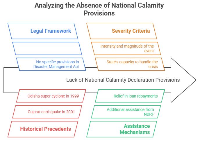
Conclusion
The effective and efficient implementation of these provisions is crucial in minimizing the impact of disasters on life, property, and the economy. Also, countries like the US have dedicated federal agencies for disaster management, and their governance frameworks could offer valuable insights to further strengthen India's disaster management capacities.
Railway Accidents and Disasters
- Indian Railways is one of the largest railway networks worldwide. Despite the reduction in accidents over the years, incidents like the Balasore Tragedy emphasize the need for better safety measures.
- Accidents are attributed to infrastructure defects, human errors, signaling failures, and Unmanned level crossings (UMLCs).
- Comparisons with foreign railway systems indicate the need for improved safety measures in India.
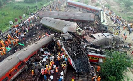
Reasons for Railway Accidents
- Infrastructure Defects: Aged infrastructure, lack of funds, and inefficiency contribute to accidents. Overcapacity is also a risk factor.
- Human Errors: The railway staff may make errors due to fatigue, negligence, or lack of adequate training, leading to miscommunication or overlooking safety rules.
- Signaling Failures: These can lead to dangerous situations such as trains running on the wrong track or overshooting stations.
- Unmanned Level Crossings: These pose a high risk of accidents as vehicles or pedestrians may not notice the approaching train.
Efforts by Railways to Enhance Safety
- Rashtriya Rail Sanraksha Kosh (RRSK): A safety fund established for critical safety related works.
- Technological Upgradation: Introduction of Modified Centre Buffer Couplers, Bogie Mounted Air Brake System (BMBS), and KAVACH - an Automatic Train Protection system.
- LHB Design Coaches: These coaches offer better safety features and a longer service life.
- GPS based Fog Pass Device: Helps loco pilots navigate in foggy conditions.
- Modern Track Structure: The use of Prestressed Concrete Sleeper (PSC), higher Ultimate Tensile Strength (UTS) rails and Steel Channel Sleepers on girder bridges have made tracks and bridges more durable.
- Ultrasonic Flaw Detection (USFD): This technique is used to detect and remove faulty rails.
- Mechanization of Track Maintenance: Machines are used for track maintenance activities reducing human errors.
- Interlocking System: Controls points and signals centrally, eliminating the need for manual operation.
- Elimination of Unmanned Level Crossings: Efforts are made to progressively eliminate UMLCs.
Recommendations from Various Committees
- Kakodkar Committee suggested a statutory Railway Safety Authority, adopting advanced technologies, and improving human resource management.
- Bibek Debroy Committee suggested separating the railway budget from the general budget and outsourcing non-core activities.
- Vinod Rai Committee recommended an independent Railway Safety Authority and Accident Investigation Board, creating a separate Railway Infrastructure Company, and a performance-linked incentive scheme for employees.
Way Forward
- More investment in safety-related work and employee training is needed. Level crossings need to be eliminated and advanced technologies adopted.
- A performance-linked incentive system could be introduced, and non-core work could be outsourced.
- The establishment of a statutory Railway Safety Authority and regular safety audits and inspections are required.
- Improved coordination and communication within railway operations is needed.
- A Confidential Incident Reporting and Analysis System (CIRAS) can encourage real-time reporting of deviations.
- The Indian Railways Management Service (IRMS) scheme should be reevaluated to promote a stronger commitment to safety.
51. Chemical disasters
The loss of containment of hazardous chemicals can lead to fire, explosions, toxic release, or a combination of them. Chemical disasters may arise at any stage of the plant/process life cycle such as commissioning, storage, manufacturing, maintenance, disposal, transportation, etc.
Causative Factors
- Aging of process plants and inadequate steps to pace with modern technologies in the Indian chemical industry.
- Structural loopholes: Fire, explosion, toxic release, and combinations of all can occur during transport, storage, and processing due to a number of reasons.
- Organic solvents: A most common source of fires and explosions in the chemical industry.
- Human error as a result of non-compliance with Standard Operating Procedures (SOPs)
- defects in design; absence of SoPs to mitigate an early warning in the process, and poor coordination between different departments.
- Improper maintenance of equipment.
Prevention and Response

Conclusion:
A chemical disaster has effects on generations of populations that are almost irreparable and the cost of that to the affected people is unimaginable. Scientific infrastructure and strong legal measures will serve the purpose and make Indian industries safe from disaster.
52. Disaster Management Plan for Power Sector
Introduction:
The Central Electricity Authority (CEA) has released the disaster management plan (DMP) for the power sector in a bid to evolve a proactive and integrated approach to strengthen disaster mitigation, preparedness, emergency response, and recovery efforts.
Need of DMP for the power sector:
- The power sector is one of the most critical infrastructures of the country.
- Any disruption due to disaster can create hardships for human beings as every aspect of human life is directly or indirectly associated with the lower Industry.
- The DMP comes as the government is investigating instances of land subsidence in the Uttarakhand Joshimath.
A disaster management plan for the power sector should include the following:
- Risk assessment: Identify potential hazards and assess the risks associated with them, such as natural disasters, human-made disasters, and cyber-attacks.
- Emergency response plan: Develop an emergency response plan that outlines the actions to be taken in case of a disaster.
- Backup power supply: Ensure that backup power supplies are available in case of power outages.
- Regular maintenance and testing: Regularly maintain and test equipment to ensure that it is functioning properly and can withstand potential disasters.
- Training and awareness: Train employees on emergency procedures and raise awareness among stakeholders about the importance of disaster preparedness.
- Coordination with other agencies: Coordinate with other agencies, such as emergency services and local authorities, to ensure a coordinated response to disasters.
- Continuity planning: Develop a continuity plan that outlines the steps to be taken to ensure the continued operation of critical infrastructure during and after a disaster.
Highlights of the DMP
- The DMP provides a framework and direction to the utilities in the power sector for all phases of the disaster management cycle.
- It is intended to guide all agencies within the sector with a general concept of potential emergencies and roles and assignments before, during, and following emergency situations.
- To estimate threats to power infrastructure, it is pertinent that fragility and vulnerability analysis is carried out for civil structures like buildings and foundations in transmission and distribution facilities.
NIDM key takeaways
- Comprehensive electrical safety audit by a fire safety professional.
- Electrical fires can be prevented by good design and installation work, equipment fir for purpose and operating environment and proper O&M practices.
- Improve the understanding of disaster risk and vulnerabilities.
- People must be educated about the danger and how to minimize them if not avoidable.
- To consider the effects of climate change, infrastructure design standards need to be enhanced.
- Technologies for generating and storing renewable energy are distributed and adaptable, and they offer resilience to climatic shocks.
- Redundancy and diversification are key to increasing the power sector resilience.
- Renewable energy can play a valuable role in power sector resilience through redundancy and energy diversification.
- We should develop resilience in the power sector as resilient infrastructure so that it should not fail in any disaster situation and even if it fails, we can recover and restore the power as quickly as possible. Resilience planning is iterative, and plans have to evolve as contexts and threats change.
53. Vulnerability in Disasters: Causes, Factors & Mitigation
Vulnerability is the human dimension of disasters and is the result of the range of economic, social, cultural, institutional, political, and psychological factors that shape people’s lives and the environment that they live in. Vulnerability describes the characteristics and circumstances of a community, system or assets that make it susceptible to the damaging effects of hazards.
|
Vulnerability= Exposure + Resistance + Resilience |
Exposure - at-risk property and population
Resistance- measures taken to reduce, avoid or prevent loss.
Resilience – the ability to recover the prior state or achieve desired post-disaster state.
Factors of Vulnerability

India’s Vulnerability Profile
- Due to its unique geo-climatic and socioeconomic conditions, India is significantly vulnerable to numerous natural and man-made disasters. These include floods, droughts, cyclones, earthquakes, landslides, avalanches, and forest fires.
- 75% of its regions are disaster-prone, with 58.6% of landmass susceptible to earthquakes and 12% to floods and river erosion. Moreover, 68% of the cultivable area is drought-vulnerable, while hilly regions risk landslides and avalanches.
- India, one of the top ten disaster-prone countries worldwide, faces such risks due to several factors including adverse geo-climatic conditions, environmental degradation, population growth, and non-scientific development practices. Every distinctive region of the country, from the Himalayan region to the coastal zone, has its specific disaster risks.
- India's geological setup contributes to its increased vulnerability. For instance, the Himalayan region and adjacent plains are susceptible to earthquakes and landslides due to their geo-tectonic features.
- Even the more stable peninsular India experiences occasional earthquakes. The alluvial plains of the Indus, Ganga, and Brahmaputra are similarly prone to seismic activities and floods due to their geological connections with the Himalayas.
- Western India, including Rajasthan, Gujarat, and parts of Maharashtra, frequently face droughts, which can extend country-wide with worsening monsoons. Oceanic pressure disturbances lead to coastal cyclones, and ongoing geo-tectonic movements risk tsunamis.
- India's disaster vulnerability is further aggravated by human activities such as deforestation, unscientific development, improper agricultural practices, unplanned urbanization, and large dam constructions on river channels. These factors accelerate disaster impact and frequency.

Vulnerability lessened by interventions at a number of points
- Impact avoidance - mitigation, action to eliminate risk during a disaster.
- Increasing knowledge related to vulnerability and risk.
- Increase capacities to cope or adopt.
- Lessen sensitivities to exposure.
- Lessen exposure to perturbations and stress.
- Well-organized response.
Since we cannot reduce the occurrence and severity of natural hazards, reducing vulnerability is one of the main opportunities for reducing disaster risk. Since we cannot reduce the occurrence and severity of natural hazards, reducing vulnerability is one of the main opportunities for reducing disaster risk.
54. Disaster resilience
Definition:
According to the Hyogo Framework for Action (UNISDR, 2005), disaster resilience is determined by the degree to which individuals, communities and public and private organisations are capable of organising themselves to learn from past disasters and reduce their risks to future ones, at international, regional, national and local levels.
The ideas of ‘bounce back’, ‘spring forward’, and ‘build back better’ are often used in the context of resilience.
- Resilience: the ability to flourish in the face of disaster risk
- Capacity: strengths and resources available to anticipate, cope with, resist and recover from disasters
- Coping capacity: the ability to face and manage disasters
Elements of a Resilience Framework:

Conclusion:
Resilience needs to be enhanced at all levels, from the local to the international. It is about preventing the creation of risk, the reduction of existing risk, and the strengthening of economic, social, health, and environmental resilience.
55. Sendai Framework for Disaster Risk Reduction
Introduction
Disasters pose significant threats to human lives, economies, and the environment, highlighting the urgent need for effective strategies to mitigate and manage their impact. The Sendai Framework for Disaster Risk Reduction, endorsed by the UN General Assembly in 2015, stands as a global commitment to reducing disaster risk and enhancing resilience. With its emphasis on collaboration, shared responsibility, and the integration of disaster risk reduction across various agendas, the framework aims to create a safer and more sustainable world. 
Importance of the Sendai Framework
- The Sendai Framework for Disaster Risk Reduction 2015-2030 (Sendai Framework) was the first major agreement of the post-2015 development agenda and provides Member States with concrete actions to protect development gains from the risk of disaster.
- The Sendai Framework is the successor instrument to the Hyogo Framework for Action (HFA) 2005-2015.
- The Sendai Framework for Disaster Risk Reduction is a crucial instrument that aligns with other key global agreements, including the Paris Agreement on Climate Change, the Addis Ababa Action Agenda on Financing for Development, the New Urban Agenda, and the Sustainable Development Goals (SDGs).
- It acknowledges the need for substantial reductions in disaster risk and the protection of lives, livelihoods, and assets in the face of increasing vulnerabilities.
Goals and Principles of the Sendai Framework
- The primary goal of the Sendai Framework is to substantially decrease disaster risk and associated losses in various sectors.
- It recognizes the pivotal role of the state in disaster risk reduction while advocating for shared responsibility among stakeholders, including local governments, the private sector, and communities.
- The framework emphasizes the integration of risk reduction into development planning and highlights the importance of promoting inclusivity, gender equality, and the participation of all sectors of society.
Key Features and Priorities
- Understanding Risk: The framework emphasizes the importance of risk assessment, data collection, and analysis to enhance the understanding of hazards, vulnerabilities, and capacities. It encourages the use of scientific knowledge and technological advancements in risk assessment processes.
- Disaster Risk Governance: Effective governance plays a vital role in disaster risk reduction. The framework promotes the development of national and local strategies, policies, and legislation to enhance risk governance and institutional coordination.
- Investing in Disaster Risk Reduction: The Sendai Framework highlights the significance of financial investments in disaster risk reduction and the importance of innovative mechanisms for financing resilience-building initiatives. It emphasizes the mobilization of resources from multiple sources and the integration of risk reduction into development planning.
- Enhancing Disaster Preparedness: Preparedness is crucial to reducing the impact of disasters. The framework emphasizes the need for early warning systems, efficient response mechanisms, and the strengthening of community resilience through education, awareness, and capacity-building initiatives.
Implementation and Follow-Up
- The United Nations Office for Disaster Risk Reduction (UNDRR) has been assigned the responsibility of supporting the implementation, follow-up, and review of the Sendai Framework.
- The framework encourages international cooperation, knowledge sharing, and the exchange of best practices to foster effective implementation at all levels.
Conclusion
- The Sendai Framework for Disaster Risk Reduction stands as a milestone agreement, emphasizing the importance of collective efforts to reduce disaster risk and build resilience.
- By integrating disaster risk reduction across multiple agendas, including climate change, development, and urban planning, the framework paves the way for a safer and more sustainable future.
- With its comprehensive goals, principles, and priorities, the Sendai Framework serves as a blueprint for governments, communities, and stakeholders to work together in mitigating the impact of disasters and safeguarding lives and livelihoods.
The Comparison between Hyogo and Sendai Framework for Disaster Risk Reduction
|
Hyogo framework |
Sendai framework |
|
|
Similarities:
- Sendai and Hyogo call for collaboration of people at the local level, fostering partnerships with the technological and private sectors to share good practices and support globally.
- They both focus on reducing global disaster mortality.
- Multi-stakeholders and inclusive approach is also what Sendai and Hyogo focus on for natural hazards.
- Technically Hyogo and Sendai have the same goals and to emphasize on this Sendai added 7 Global targets to measure DRR (Disaster Risk Reduction) in its framework.
- Disaster Risk Reduction is the concept and practice of reducing disasters through systematic efforts to analyze the exposures of disasters.
Conclusion: In the mission of Disaster Risk Reduction, there is a need for collaboration by all entities, public and private, to strengthen the mechanisms for disaster risk reduction by using and sharing reliable and affordable modern technology for capacity building.
Coalition of Disaster Resilient Infrastructure (CDRI):
The Coalition for Disaster Resilient Infrastructure (CDRI) is a groundbreaking international initiative designed to address the challenges of building resilience in infrastructure systems. It was launched by India's Prime Minister Narendra Modi at the United Nations Climate Action Summit in September 2019, with a goal to promote the resilience of new and existing infrastructure systems to climate and disaster risks, thereby ensuring sustainable development.
Key Features of CDRI:
- Multi-National Collaboration: CDRI is a global coalition, involving public and private sector entities, which aims to combine the efforts of a number of nations to build disaster-resilient infrastructure. As of 2021, many countries including Australia, the United Kingdom, the United States, France, and Japan have become part of this initiative.
- Scope and Focus: CDRI seeks to address the challenges of resilience in the context of both physical infrastructure (such as energy, water, transport, and telecommunications) and social infrastructure (such as health and education facilities).
- Research and Technical Assistance: CDRI is poised to serve as a platform where member countries can exchange knowledge and leverage technology to make infrastructure more resilient against natural disasters. It includes scientific and engineering research, the development of standards, and providing technical assistance.
- Capacity Building and Policy Making: One of CDRI's objectives is to help nations build their capacity and formulate policies for resilient infrastructure. This is achieved by establishing systems and frameworks that take into account disaster and climate risks in the design, construction, and operation of infrastructure.
- Promotion of Investments: CDRI encourages investments in resilient infrastructure, recognizing the economic feasibility of such investments, and promoting the concept of "building back better" after disasters. It seeks to guide the private sector and multilateral development banks to incorporate risk-informed decision-making in their investment decisions.
- Climate Change Adaptation: The CDRI also emphasizes the role of resilient infrastructure in adaptation to climate change, understanding that infrastructure will play a crucial role in either exacerbating the effects of climate change or mitigating them.
Conclusion: In a world where climate change is expected to increase the frequency and intensity of natural disasters, the need for resilient infrastructure cannot be overstated. The Coalition for Disaster Resilient Infrastructure (CDRI) stands as a crucial international initiative aiming to foster collaboration and knowledge sharing among member nations. Its comprehensive approach to resilience not only encompasses physical infrastructure but also the social infrastructure crucial to people's well-being. As it gains more support and evolves, the CDRI has the potential to greatly mitigate the impacts of disasters on global economies and communities, and shape a sustainable and resilient future.
56. India's efforts in disaster management
|
Legal and Institutional Measure
|
Technological Measures
|
Community-based participation
|
Way forward for Disaster Management :
- Establishing a robust Disaster Information Management System should be among the government’s highest priorities to facilitate risk-informed development, comprehensive and contextual urban development and hazard mapping vis-à-vis vulnerabilities and capacities of any given district.
- Community Based Disaster Risk Management should be increasingly highlighted as a driver for resilient development in the DRM infrastructure of India.
- Identifying sustainable and holistic financing mechanism for the integration of DRR and CCA into wider development is necessary given the pressures caused by climate change and disasters.
- Risk-informed planning should not stop there either must become a whole-of society issue from the national to household levels, especially now that most of the country could be experiencing impacts of worsening hydrometeorological hazards with increasing regularity.
India has made commendable progress in disaster management, weaving together legislative, executive, and technological strategies. However, there's still a continuous need for strengthening and updating these strategies, given the increasing disaster risks due to climate change and rapid urbanization. Constant vigilance, planning, and implementation are necessary to build a disaster-resilient Nat
57. Crowd Management and Disasters Due to Large Crowd Presence
Introduction:
Crowd management is the systematic process of planning, organizing, and monitoring large gatherings of people with the objective to establish a safe and secure environment and maintain a minimum level of space to avoid panic and rapid crowd movements.
Causes of crowd disasters:
- Overcrowding: When too many people are present in a confined space, it can lead to stampedes, trampling, and suffocation.
- Poor crowd management: Inadequate planning, lack of crowd control measures, and insufficient emergency exits can contribute to crowd disasters.
- Panic: Fear and anxiety can cause people to act irrationally and make poor decisions, leading to chaos and accidents.
- Structural failures: Weak or poorly maintained structures such as bridges, stadiums, and buildings can collapse under the weight of large crowds.
- Natural disasters: Earthquakes, floods, and other natural disasters can cause panic and chaos among crowds, leading to injuries and fatalities.
- Terrorism: Acts of terrorism such as bombings or shootings can cause panic and chaos among crowds, leading to injuries and fatalities.
NDMA Guidelines for Crowd Management:
Refer diagram ????

|
Case studies for crowd management
|
Challenges for crowd management:
- Lack of sufficient manpower- to handle large masses
- Lack of trained personnel- who can deploy and assist the crowd in a sophisticated way
- Technology constraints - lack of modern technology such as instant networks, facial recognition system, etc.
Better crowd Management Planning:
- Proper planning: Event organizers should conduct a risk assessment and develop a crowd management plan that includes measures to prevent overcrowding, ensure adequate exits, and provide emergency medical services.
- Crowd control measures: such as barricades, crowd marshals, and ticketing systems to regulate the flow of people and prevent overcrowding.
- Communication: between event organizers, security personnel, and emergency responders to ensure timely response in case of an emergency.
- Training: Crowd management personnel should be trained in crowd control techniques, first aid, and emergency response procedures.
- Emergency preparedness: Event organizers should have a contingency plan in place to respond to emergencies such as fires, stampedes, and natural disasters.
- Use of technology: Use of facial recognition used in Kumbh Mela.
- Awareness campaign: Such as education and awareness among people.
Conclusion: Insufficient manpower and inefficient strategies are responsible for turning crowds into crowd disasters. Implementing NDMA guidelines to control crowds will be helpful for better management.

2026-27 UPSC Mains English QEP Power Pages
View DetailsSubmit Your Details to Learn More


 Detailed Solutions & Explanations
