


Explore Mapping of the Ocean Floor, bathymetry techniques like multibeam sonar, satellite altimetry, and ROVs. Learn its importance for marine ecosystems, tectonics, resources, and discover major global landforms across continents.
 theIASHub | 24 Sep, 2025

Mapping of the ocean floor, also known as bathymetry, is a crucial process for understanding the topography, geological features, and ecosystems of the Earth's oceans.

The ocean floor covers more than 70% of the Earth's surface and plays a vital role in regulating climate, supporting marine life, and understanding Earth's geological history.
Accurate mapping helps in identifying underwater features like ridges, trenches, seamounts, and plate boundaries, providing valuable insights into tectonic activity and the formation of natural resources.
Mapping assists in locating potential fishing zones, identifying mineral deposits, and assessing the environmental impact of human activities such as oil and gas exploration, deep-sea mining, and submarine cable installations.
Early attempts at ocean floor mapping were done using lead lines, which provided limited information about the depth but lacked precision.
The advent of echo sounders in the early 20th century allowed for more accurate measurements. Echo sounders emit sound waves and measure the time taken for the sound to reflect back, providing depth information.
Multibeam Sonar:
Multibeam sonar systems use multiple beams of sound waves to provide detailed bathymetric data.
These systems can cover a wide swath of the seafloor and produce high-resolution maps.
Multibeam sonar data helps in identifying seafloor features, such as underwater mountains, canyons, and sediment distribution.
Satellite Altimetry:
Satellite altimetry measures the height of the sea surface with high precision.
By detecting subtle variations in sea surface height caused by gravitational forces and variations in seafloor topography, it indirectly provides information about the ocean floor.
This technique helps in mapping large-scale features like mid-ocean ridges and major ocean basins.
Remotely Operated Vehicles (ROVs) and Autonomous Underwater Vehicles (AUVs):
ROVs and AUVs equipped with sonar systems and cameras are used for detailed mapping of specific areas or inaccessible regions.
They provide high-resolution imagery and collect data on underwater features, marine life, and geological samples.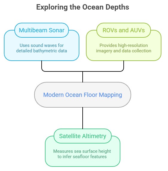
The General Bathymetric Chart of the Oceans (GEBCO) is a global initiative to create and provide freely available bathymetric data sets.
The Seabed 2030 project, a collaboration between GEBCO and the Nippon Foundation, aims to map the entire ocean floor by 2030.
Several countries, including the United States, Canada, Japan, and European nations, have their own programs for mapping the ocean floor.
Mapping the ocean floor is a vast and challenging task due to the sheer size and depth of the oceans.
Technological advancements, such as improved multibeam sonar systems and autonomous underwater vehicles, are enhancing data collection capabilities.
The development of advanced data processing techniques, machine learning algorithms, and artificial intelligence is facilitating faster and more accurate analysis of bathymetric data.
Continued efforts in ocean floor mapping are crucial for understanding marine ecosystems, identifying potential resources, and managing human activities sustainably.
Landforms across the world are diverse and varied, showcasing the Earth's rich geological history and the dynamic processes that have shaped the planet's surface.

North America:
Rocky Mountains: Stretching from Canada to the United States, the Rocky Mountains are a vast mountain range known for their rugged peaks, deep valleys, and scenic landscapes.
Grand Canyon: Located in Arizona, USA, the Grand Canyon is a massive canyon carved by the Colorado River over millions of years, revealing spectacular rock formations and layers.
Great Plains: The Great Plains are vast flatlands covering parts of the United States and Canada, characterized by extensive grasslands and agricultural regions.
South America
Andes Mountains: The Andes, running along the western edge of South America, are the world's longest mountain range, featuring towering peaks, deep valleys, and active volcanoes.
Amazon Rainforest: The Amazon Rainforest, spanning multiple South American countries, is a vast tropical rainforest known for its biodiversity and the mighty Amazon River.
Europe
Alps: The Alps, stretching across several European countries, including Switzerland, France, and Italy, are a famous mountain range known for its picturesque landscapes, snow-capped peaks, and world-renowned ski resorts.
Norwegian Fjords: Along the western coast of Norway, fjords—deep, narrow inlets—carved by glaciers create stunning landscapes of steep cliffs, waterfalls, and calm waters.
Africa
Sahara Desert: The Sahara is the world's largest hot desert, spanning across northern Africa, characterized by vast stretches of sand dunes, rocky plateaus, and arid landscapes.
Mount Kilimanjaro: Located in Tanzania, Mount Kilimanjaro is the highest peak in Africa, featuring distinct volcanic cones and a snow-capped summit.
Asia
Himalayas: The Himalayas, running through several Asian countries, including Nepal, India, and China, are the world's highest mountain range, featuring majestic peaks like Mount Everest and deep valleys.
Gobi Desert: The Gobi Desert, spanning across China and Mongolia, is a vast arid region with a mixture of sand dunes, rocky outcrops, and unique desert landscapes.
Australia and Oceania
Great Barrier Reef: Off the coast of Australia, the Great Barrier Reef is the world's largest coral reef system, showcasing a stunning underwater world with diverse marine life.
Uluru (Ayers Rock): Located in Australia's Northern Territory, Uluru is a massive sandstone monolith and an iconic landmark.
These are just a few examples of the remarkable landforms found across the world. Each continent and region has its own distinctive geological features, reflecting the complex and dynamic processes that have shaped our planet over millions of years.


Refine your answer writing skills and elevate your UPSC preparation with personalized support and expert feedback.
Fill out the form to get started with the program or any other enquiries !


Are you dreaming of becoming an IAS officer? Then, IAShub can be your best guide. It is one of the Best IAS Coaching in Delhi. Many students who want to clear the UPSC exam join IAShub for learning. The institute gives both online and offline classes. Their teachers are experienced and helpful. They easily explain every topic. Students also get notes, tests, and tips to do well in the exam.
IAShub is in Delhi and is trusted by many UPSC students. It offers coaching for every part of the UPSC exam – Prelims, Mains, and Interview. The classes are simple and easy to understand. The teachers are experts and guide students in the right way. IAShub is also known for its helpful notes, test series, and answer-writing practice. IAShub is the best coaching in Delhi and also gives UPSC Online Classes. This helps students from any place in India to learn. The online classes are live and also recorded. So, students can watch them anytime. These classes cover the full UPSC syllabus.
Here are some important services provided by IAShub:
The UPSC Civil Services Exam has three parts:
This exam is tough, but with the right guidance, it becomes easy to manage. Students must study smart and stay regular.
IAShub supports students from the beginning to the end. It gives the right books, tests, and notes. The classes are easy to follow, and the teachers are always ready to help. Students get personal doubt sessions too. The test series and answer checking help students learn where they need to do better. Also, free study materials save time and money.
IAShub also guides students during the final stage – the interview. Experts take mock interviews and give useful tips. This full support makes IAShub one of the best IAS coaching in Delhi.
 Detailed Solutions & Explanations
Improve Your Answer Writing & Strategy
Detailed Solutions & Explanations
Improve Your Answer Writing & Strategy
